File:Crete topographic map-ru.jpeg
Jump to navigation
Jump to search
Size of this preview: 800 × 380 pixels. Other resolutions: 320 × 152 pixels | 640 × 304 pixels | 1,024 × 486 pixels | 1,280 × 608 pixels | 2,200 × 1,045 pixels.
Original file (2,200 × 1,045 pixels, file size: 300 KB, MIME type: image/jpeg)
Captions
Captions
Add a one-line explanation of what this file represents
Summary
[edit]
| Description |
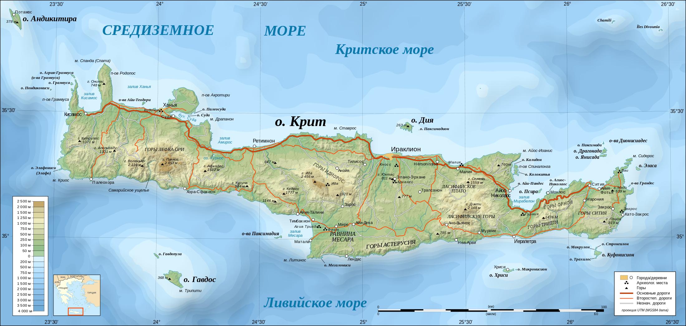
UTM projection; WGS84 datum; shaded relief (composite image of N-W, W and N lightning positions) Approximate scales: *Topographic data and shore / lakes limits: 1:400,000 (accuracy: about 100 m) ; *Bathymetry: 1:14,800,000 (accuracy: about 3,700 m) ; Note: The shaded relief is a raster image embedded in the SVG file. |
| Date | (UTC) |
| Source |
This file was derived from: Crete topographic map-ru.svg: |
| Author |
|
| This is a retouched picture, which means that it has been digitally altered from its original version. Modifications: разрешение, формат. The original can be viewed here: Crete topographic map-ru.svg:
|
Licensing
[edit]
I, the copyright holder of this work, hereby publish it under the following licenses:
This file is licensed under the Creative Commons Attribution-Share Alike 3.0 Unported, 2.5 Generic, 2.0 Generic and 1.0 Generic license.
- You are free:
- to share – to copy, distribute and transmit the work
- to remix – to adapt the work
- Under the following conditions:
- attribution – You must give appropriate credit, provide a link to the license, and indicate if changes were made. You may do so in any reasonable manner, but not in any way that suggests the licensor endorses you or your use.
- share alike – If you remix, transform, or build upon the material, you must distribute your contributions under the same or compatible license as the original.

|
Permission is granted to copy, distribute and/or modify this document under the terms of the GNU Free Documentation License, Version 1.2 or any later version published by the Free Software Foundation; with no Invariant Sections, no Front-Cover Texts, and no Back-Cover Texts. A copy of the license is included in the section entitled GNU Free Documentation License. |
You may select the license of your choice.
Original upload log
[edit]
This image is a derivative work of the following images:
- File:Crete_topographic_map-ru.svg licensed with Cc-by-sa-3.0,2.5,2.0,1.0, GFDL
- 2009-10-11T10:34:31Z Переход Артур 3370x1600 (2730051 Bytes) == {{int:filedesc}} == {{Location|35|20|00|N|25|00|00|E|scale:2000000}} {{Information |Description= {{ru|Топографическая карта острова [[:ru:Крит]] ([[:ru:Греция]]) на русском я
Uploaded with derivativeFX
File history
Click on a date/time to view the file as it appeared at that time.
| Date/Time | Thumbnail | Dimensions | User | Comment | |
|---|---|---|---|---|---|
| current | 23:31, 18 January 2012 | | 2,200 × 1,045 (300 KB) | Chtototakoe (talk | contribs) | == {{int:filedesc}} == {{Information |Description={{ru|Топографическая карта острова Крит (Греция) на русском языке.}} {{en|Topographic map in Russian of [[:en:Crete| |
You cannot overwrite this file.
File usage on Commons
There are no pages that use this file.