File:Creque Marine Railway, Title Sheet - Creque Marine Railway, Charlotte Amalie, St. Thomas, VI HAER VI,3-HASI,1- (sheet 1 of 9).png
Jump to navigation
Jump to search

Size of this preview: 800 × 533 pixels. Other resolutions: 320 × 213 pixels | 640 × 426 pixels | 1,024 × 682 pixels | 1,280 × 853 pixels | 2,560 × 1,705 pixels | 14,458 × 9,632 pixels.
Original file (14,458 × 9,632 pixels, file size: 6.56 MB, MIME type: image/png)
Captions
Captions
Add a one-line explanation of what this file represents
| This image is a JPEG version of the original TIF image at File: Creque Marine Railway, Title Sheet - Creque Marine Railway, Charlotte Amalie, St. Thomas, VI HAER VI,3-HASI,1- (sheet 1 of 9).tif.
However, any edits to the image should be based on the original TIF version in order to prevent generation loss, and both versions should be updated. Do not make edits based on this version. |
Summary
[edit]| Warning | The original file is very high-resolution. It might not load properly or could cause your browser to freeze when opened at full size. |
|---|
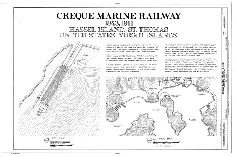
| Creque Marine Railway, Title Sheet - Creque Marine Railway, Charlotte Amalie, St. Thomas, VI | ||||
|---|---|---|---|---|
| Photographer |
Long, Chalmers G. Jr. |
|||
| Title |
Creque Marine Railway, Title Sheet - Creque Marine Railway, Charlotte Amalie, St. Thomas, VI |
|||
| Description |
St Thomas Marine Railway Company; Rothschild, L; Recht, W; Creque, Henry O; Harley, Alfonz; Creque, Herman O; Creque, Henry O, Jr; Morris, Scott, transmitter; DeBoer, Ruth, transmitter; Virgin Islands Planning Office, sponsor; Delony, Eric, project manager |
|||
| Depicted place | Virgin Islands (US); St. Thomas; Charlotte Amalie | |||
| Date | 1977 | |||
| Dimensions | 24 x 36 in. (D size) | |||
| Current location |
Library of Congress Prints and Photographs Division Washington, D.C. 20540 USA http://hdl.loc.gov/loc.pnp/pp.print |
|||
| Accession number |
HAER VI,3-HASI,1- (sheet 1 of 9) |
|||
| Credit line |
|
|||
| Notes |
|
|||
| Source | https://www.loc.gov/pictures/item/vi0026.sheet.00001a | |||
| Permission (Reusing this file) |
|
|||
| Other versions |
.png) .png) .png) .png) .png) .png) |
|||

.png&action=edit§ion=1)
.png&flash=no)
File history
Click on a date/time to view the file as it appeared at that time.
| Date/Time | Thumbnail | Dimensions | User | Comment | |
|---|---|---|---|---|---|
| current | 13:27, 31 August 2014 | | 14,458 × 9,632 (6.56 MB) | Fæ (talk | contribs) | {{Compressed version|file=File:Creque_Marine_Railway,_Title_Sheet_-_Creque_Marine_Railway,_Charlotte_Amalie,_St._Thomas,_VI_HAER_VI,3-HASI,1-_(sheet_1_of_9).tif|thumb=nothumb}} =={{int:filedesc}}== {{Photograph | accession number = HAER VI,3-HASI,1-... |
You cannot overwrite this file.
File usage on Commons
The following 3 pages use this file:
- File:Creque Marine Railway, Title Sheet - Creque Marine Railway, Charlotte Amalie, St. Thomas, VI HAER VI,3-HASI,1- (sheet 1 of 9).png
- File:Machinery, Elevation and Plans - Creque Marine Railway, Charlotte Amalie, St. Thomas, VI HAER VI,3-HASI,1- (sheet 7 of 9).tif
- File:Machinery, North Elevation - Creque Marine Railway, Charlotte Amalie, St. Thomas, VI HAER VI,3-HASI,1- (sheet 8 of 9).tif
.png)
.png&oldid=870896030)