File:Craigendoran railway station, Argyll & Bute (geograph 3917995).jpg
Jump to navigation
Jump to search

Size of this preview: 800 × 600 pixels. Other resolutions: 320 × 240 pixels | 640 × 480 pixels | 1,024 × 768 pixels.
Original file (1,024 × 768 pixels, file size: 154 KB, MIME type: image/jpeg)
Captions
Captions
Add a one-line explanation of what this file represents
Summary
[edit].jpg&action=edit§ion=1)
| Description |
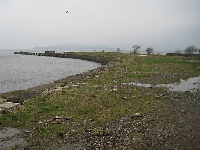
English: Craigendoran railway station, Argyll & Bute Opened in 1882 by the North British Railway on the line from Dunfermline to Helensburgh, this station once had six platforms - 2 on the West Highland line, 2 adjacent ones on the Helensburgh Central line (both behind the camera position), and 2 here, curving around on to the pier to make connections with Clyde steamers. Now, only one platform remains, on the Helensburgh line. The last steamer called here in 1972. |
| Date | |
| Source | From geograph.org.uk |
| Author | Nigel Thompson |
| Permission (Reusing this file) |
Creative Commons Attribution Share-alike license 2.0 |
| Attribution (required by the license) | Nigel Thompson / Craigendoran railway station, Argyll & Bute / |
| Camera location | | View this and other nearby images on: OpenStreetMap |
|---|
.jpg¶ms=055.994515_N_-004.711705_E_globe:Earth_type:camera_source:geograph-osgb36(NS30978127)_heading:292.00&language=en)
| Object location | | View this and other nearby images on: OpenStreetMap |
|---|
.jpg¶ms=055.994680_N_-004.712360_E_globe:Earth_class:object_type:object_source:geograph-osgb36(NS30938129)_heading:292.00&language=en)
Licensing
[edit].jpg&action=edit§ion=2)

|
This image was taken from the Geograph project collection. See this photograph's page on the Geograph website for the photographer's contact details. The copyright on this image is owned by Nigel Thompson and is licensed for reuse under the Creative Commons Attribution-ShareAlike 2.0 license.
|
This file is licensed under the Creative Commons Attribution-Share Alike 2.0 Generic license.
Attribution: Nigel Thompson
- You are free:
- to share – to copy, distribute and transmit the work
- to remix – to adapt the work
- Under the following conditions:
- attribution – You must give appropriate credit, provide a link to the license, and indicate if changes were made. You may do so in any reasonable manner, but not in any way that suggests the licensor endorses you or your use.
- share alike – If you remix, transform, or build upon the material, you must distribute your contributions under the same or compatible license as the original.
File history
Click on a date/time to view the file as it appeared at that time.
| Date/Time | Thumbnail | Dimensions | User | Comment | |
|---|---|---|---|---|---|
| current | 23:03, 3 January 2020 | | 1,024 × 768 (154 KB) | Lamberhurst (talk | contribs) | Transferred from geograph.co.uk using [https://tools.wmflabs.org/geograph2commons/ geograph2commons] |
You cannot overwrite this file.
File usage on Commons
The following page uses this file:
.jpg&oldid=870645971)