File:Coventry's Other River. The Sowe- London Road to Stoneleigh- Stoneleigh Bridge to Sowe Mouth- St Mary the Virgin Stoneleigh-in-Arden.jpg

Original file (2,566 × 3,552 pixels, file size: 6.51 MB, MIME type: image/jpeg)
Captions
Captions
Summary
[edit]
| Description |
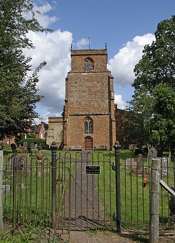
English: The River Sowe crosses the London Road at Willenhall Bridge, to then meander south and later west past Whitley Grove Wood to Stonebridge Meadows Nature Reserve. Turning south it crosses beneath the A45 Stonebrige Highway at the 1938 River Sowe Bridge. Just south of this point it is joined by Coventry’s famous river Sherbourne and together they skirt around the Lunt Roman Fort at Baginton, through the Old Mill to finally circumnavigate the high ground upon which Bagot’s Castle stands. The river then passes behind Finham Sewage Works to the village of Stoneleigh where it flows beneath the historic eight arched Stoneleigh Bridge. Passing below the church it finally flows into Stoneleigh Park where it joins the River Avon. The rest of its journey to the sea is, of course, the stuff of legends.
The River Sowe is a river in Warwickshire and West Midlands. It is a tributary of the River Avon, and flows into it just south of Stoneleigh about 5 miles (8 km) south of Coventry. It is about 12 miles (19 km) long. The Sowe rises in Bedworth 5.5 miles (9 km) to the north of Coventry. Its route takes it through Exhall near to Junction 3 of the M6 motorway and the A444 road, to the northern and then the eastern suburbs of Coventry, in particular the districts of Longford, Wood End, Walsgrave, Binley, Willenhall and near the village of Baginton. Near Baginton the river has a large steep bank on its southern side and the remains of the Roman Lunt Fort have been found at the top of this bank. There is an established local park called the Sowe Valley Footpath that runs alongside the river for 8½ miles from Hawkesbury Junction Conservation Area to Stonebridge Meadows Local Nature. It also runs through Wyken Slough Local Nature Reserve, Wyken Croft Nature Park and Stoke Floods Local Nature Reserve. |
| Date | |
| Source | https://www.flickr.com/photos/15181848@N02/48528950826/ |
| Author | amandabhslater |
| Camera location | | View this and other nearby images on: OpenStreetMap |
|---|
Licensing
[edit]
- You are free:
- to share – to copy, distribute and transmit the work
- to remix – to adapt the work
- Under the following conditions:
- attribution – You must give appropriate credit, provide a link to the license, and indicate if changes were made. You may do so in any reasonable manner, but not in any way that suggests the licensor endorses you or your use.
- share alike – If you remix, transform, or build upon the material, you must distribute your contributions under the same or compatible license as the original.
| This image was originally posted to Flickr by amandabhslater at https://flickr.com/photos/15181848@N02/48528950826. It was reviewed on 12 May 2022 by FlickreviewR 2 and was confirmed to be licensed under the terms of the cc-by-sa-2.0. |
File history
Click on a date/time to view the file as it appeared at that time.
| Date/Time | Thumbnail | Dimensions | User | Comment | |
|---|---|---|---|---|---|
| current | 17:44, 12 May 2022 | | 2,566 × 3,552 (6.51 MB) | Ser Amantio di Nicolao (talk | contribs) | Uploaded a work by amandabhslater from https://www.flickr.com/photos/15181848@N02/48528950826/ with UploadWizard |
You cannot overwrite this file.
File usage on Commons
There are no pages that use this file.