File:County of the City of Dublin 1837 map.jpg
Jump to navigation
Jump to search

Size of this preview: 800 × 568 pixels. Other resolutions: 320 × 227 pixels | 640 × 455 pixels | 1,024 × 728 pixels | 1,280 × 910 pixels | 2,560 × 1,819 pixels | 4,855 × 3,450 pixels.
Original file (4,855 × 3,450 pixels, file size: 2.36 MB, MIME type: image/jpeg)
Captions
Captions
Add a one-line explanation of what this file represents
Summary
[edit]
| Description |
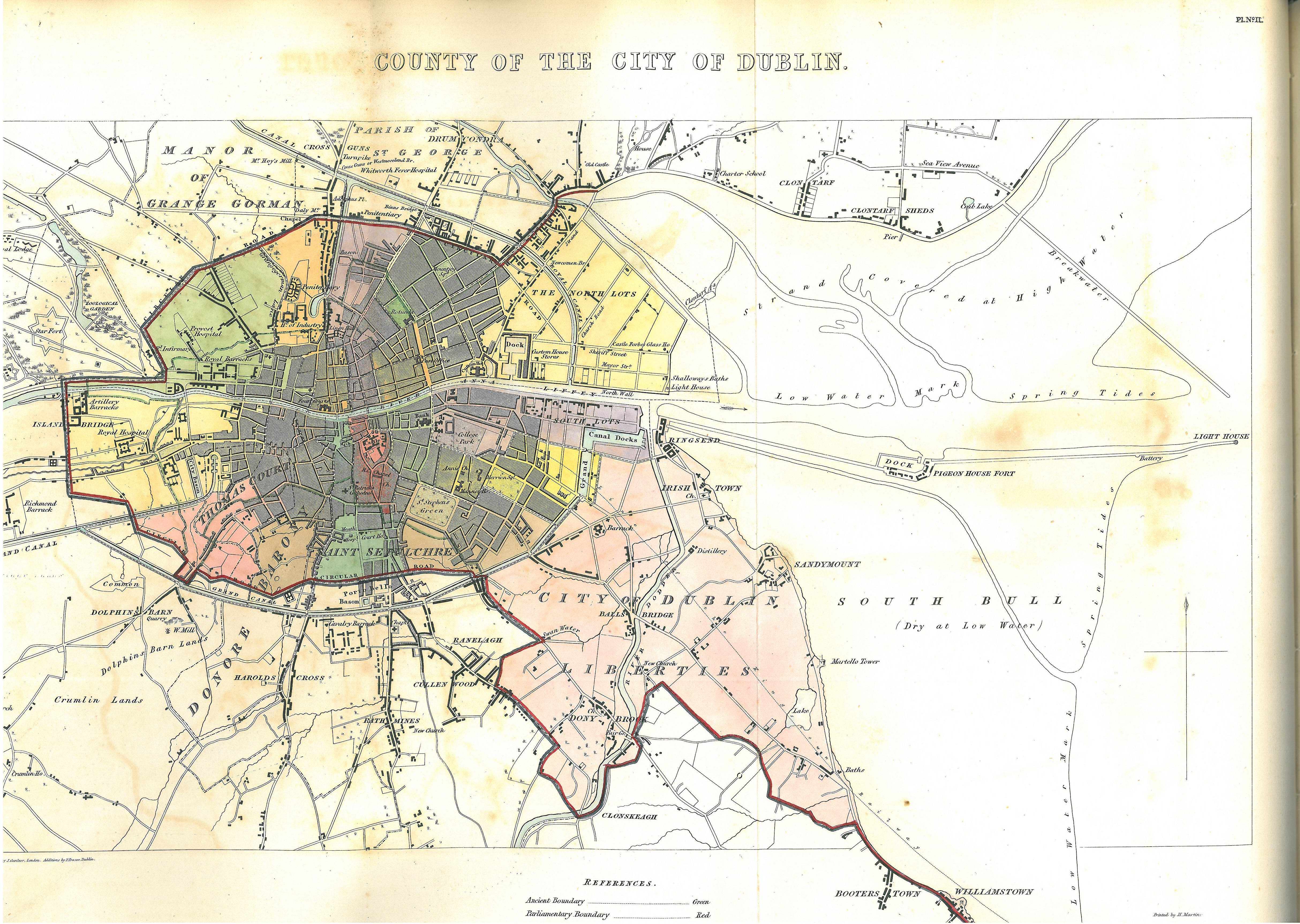
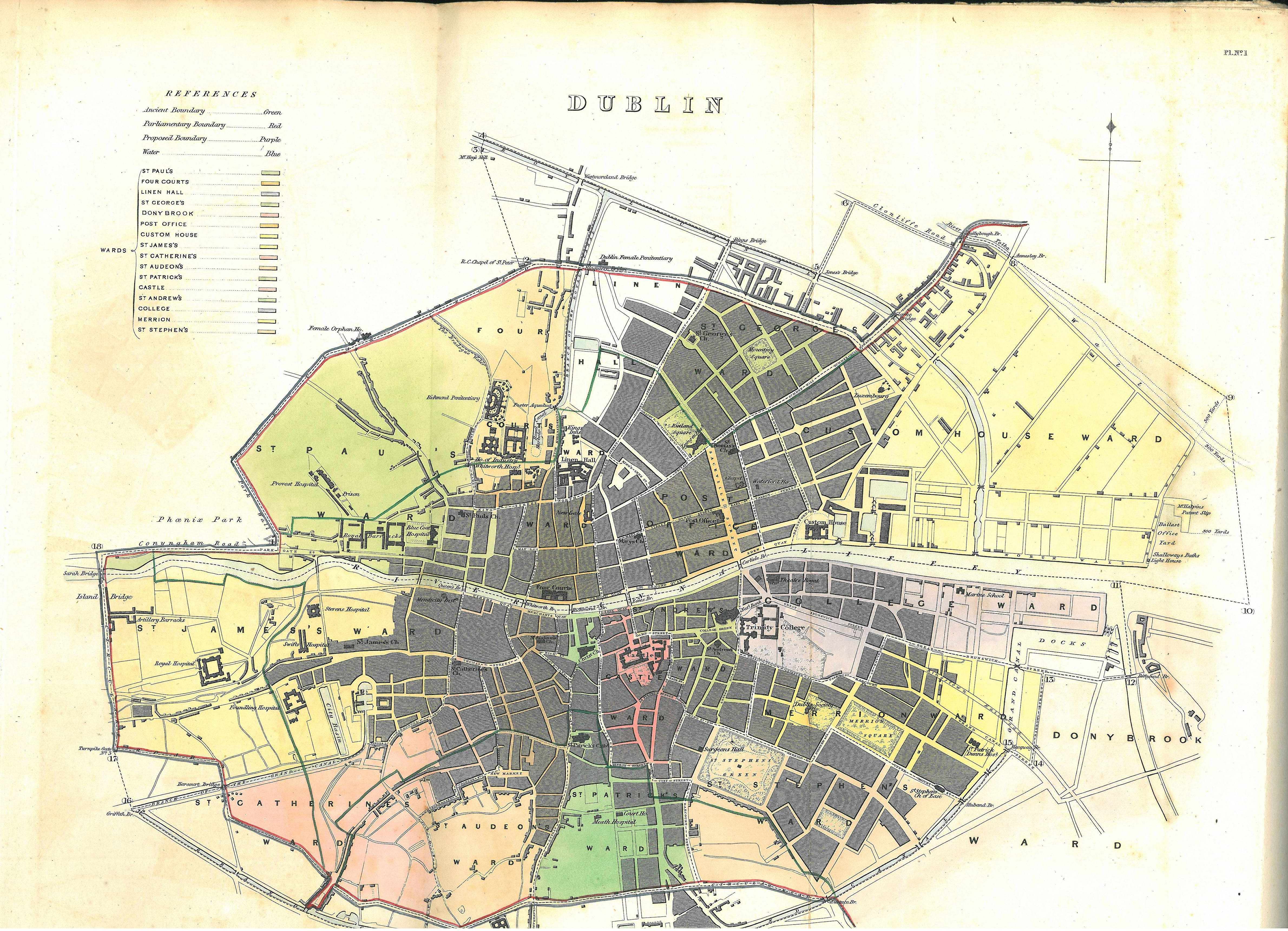
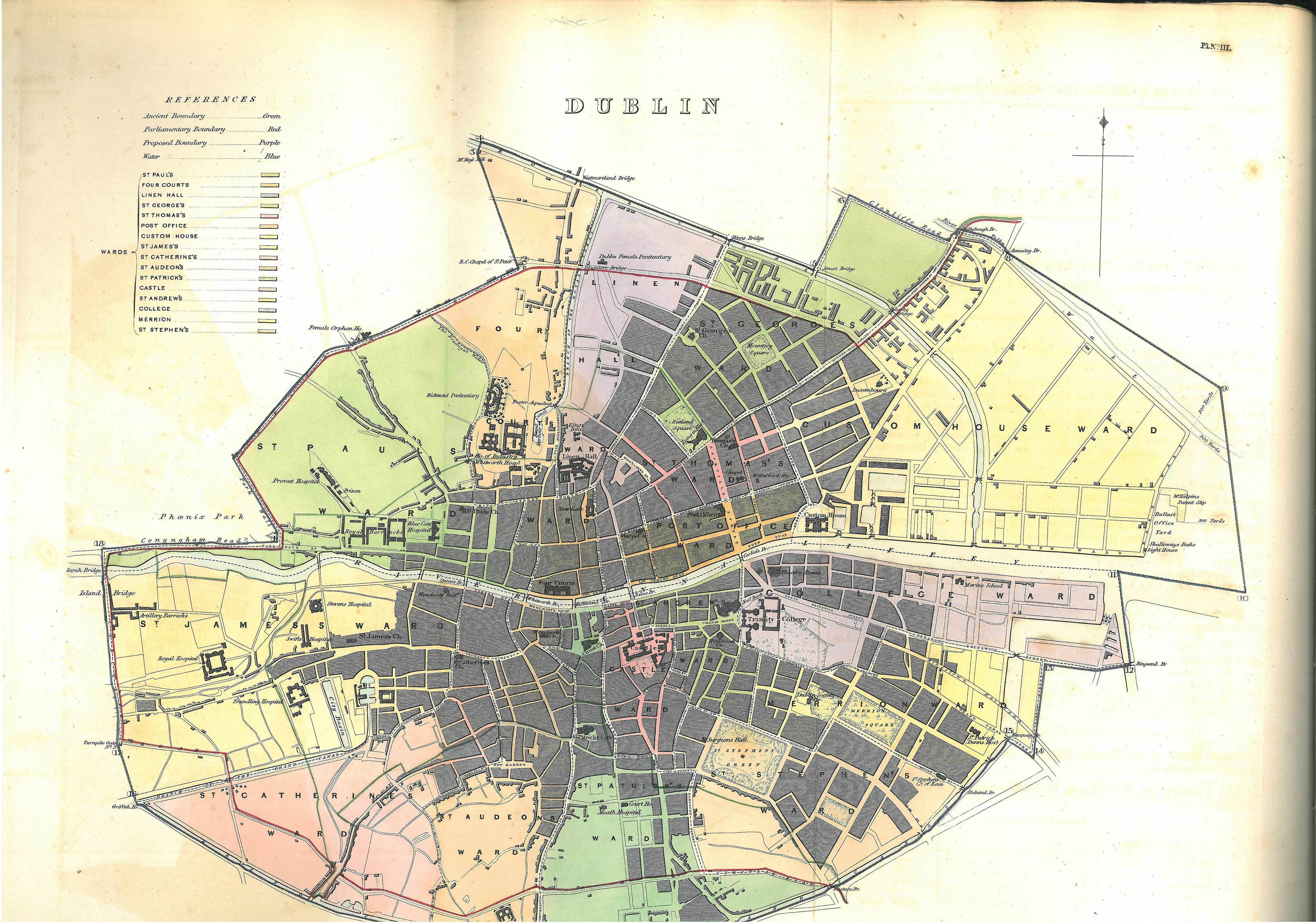
English: A map of Dublin and environs included in the 1837 report of the Municipal Corporation Boundaries (Ireland) Commissioners.[1] The map shows:
|
| Date | |
| Source | http://www.limerickcity.ie/media/032%20map%20dublin%202.jpg |
| Author | Commissioners for Municipal Corporation Boundaries, Ireland |
Licensing
[edit]
This work created by the United Kingdom Government is in the public domain.
This is because it is one of the following:
HMSO has declared that the expiry of Crown Copyrights applies worldwide (ref: HMSO Email Reply)
|
 |
- ↑ HC sessional papers, 10 May 1837 (301) 29 3; Map 2 between pp.60 and 61
- ↑ Commissioners appointed to inquire into the municipal corporations in Ireland (1836) "Appendix II. Manorial Jurisdictions or Liberties." in Appendix to the first report: report on the city of Dublin, Sessional papers, HC 1836 [26] 24 297, H.M. Stationery Office, p. 289, fn "The "liberties of the city," mentioned in the 10 Geo. I. c. 3; 11 Geo. II. c. 11, s. 10; 11 Geo. 11. c. 13, s. 3 ; 11, 12 Geo. III. c. 11, s. 50, and several other Acts, are evidently distinguished from the liberties of St. Sepulchre's, of Thomas Court and Donore, of St. Patrick's, and of Christ Church, which are described as liberties "adjoining" the city."
- ↑ "Dublin [A district, formerly of peculiar jurisdiction, and commonly called the county of the city of Dublin]" in (1846) The Parliamentary Gazetteer of Ireland, II, A. Fullarton, p. 98
- ↑ Lewis, Samuel (1837). Appendix; Shewing the Boundaries of the Cities and Boroughs in Ireland. A Topographical Dictionary of Ireland. ; Commissioners on Boundaries of Cities and Boroughs of Ireland (8 June 1832) "REPORT on the County of the City of Dublin" in Reports from Commissioners and Plans, Sessional papers, HC 1831–32 (519), xliii, 146, pp. 51–56
- ↑ HC sessional papers, 10 May 1837 (301) 29 3; Map 1 between pp.60 and 61 for closeup map and pp.64–68 for detail.
- ↑ HC sessional papers, 10 May 1837 (301) 29 3; Map 3 between pp.60 and 61 for closeup map and pp.69–74 for detail. Compare Index to the Sheets of the Ordnance Map of the City of Dublin (1848).
- ↑ 13 & 14 Victoria c.55
- ↑ 5 & 6 Victoria c.96
File history
Click on a date/time to view the file as it appeared at that time.
| Date/Time | Thumbnail | Dimensions | User | Comment | |
|---|---|---|---|---|---|
| current | 10:00, 6 June 2017 | | 4,855 × 3,450 (2.36 MB) | Jnestorius (talk | contribs) | User created page with UploadWizard |
You cannot overwrite this file.
File usage on Commons
The following page uses this file:
File usage on other wikis
The following other wikis use this file:
- Usage on en.wikipedia.org
- Usage on ga.wikipedia.org