File:County Named, 1800 historical marker.jpg
Jump to navigation
Jump to search

Size of this preview: 800 × 532 pixels. Other resolutions: 320 × 213 pixels | 640 × 426 pixels | 1,024 × 681 pixels | 1,280 × 851 pixels | 2,560 × 1,702 pixels | 6,016 × 4,000 pixels.
Original file (6,016 × 4,000 pixels, file size: 5.58 MB, MIME type: image/jpeg)
Captions
Captions
Add a one-line explanation of what this file represents
| Camera location | | View this and other nearby images on: OpenStreetMap |
|---|
| Description |
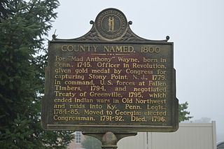
English: Historical marker on the southwestern corner of the junction of Main (Kentucky Route 92) and Court Streets in Monticello, Kentucky, United States. |
|||||
| Date | Taken on 25 July 2014 | |||||
| Source | Own work | |||||
| Author | Nyttend | |||||
| Permission (Reusing this file) |
Marker and photo respectively:
|

File history
Click on a date/time to view the file as it appeared at that time.
| Date/Time | Thumbnail | Dimensions | User | Comment | |
|---|---|---|---|---|---|
| current | 20:00, 18 August 2014 | | 6,016 × 4,000 (5.58 MB) | Nyttend (talk | contribs) | {{Location|36|49|48.3|N|84|50|55.7|W}} {{Information |Description={{en|Historical marker on the southwestern corner of the junction of Main ({{w|Kentucky Route 92}}) and Court Streets in {{w|Monticello, Kentucky|Monticello}}, {{w|Kentucky}}, {{w|United... |
You cannot overwrite this file.
File usage on Commons
The following page uses this file:
Metadata
Categories:
- Historical markers in Kentucky
- Kentucky Historical Marker program
- Monticello, Kentucky
- Kentucky Route 92
- Signs in Wayne County, Kentucky
- Monuments and memorials to Anthony Wayne
- Monuments and memorials of the Northwest Indian War
- Plaques referencing 1800 in the United States
- Plaques to people of the United States
- History of Wayne County, Kentucky
- 1800 in Kentucky