File:County Lock in flood, Reading.jpg
Jump to navigation
Jump to search
No higher resolution available.
County_Lock_in_flood,_Reading.jpg (640 × 480 pixels, file size: 152 KB, MIME type: image/jpeg)
Captions
Captions
Add a one-line explanation of what this file represents
Summary
[edit]
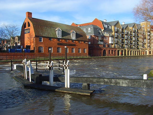
| Description | County Lock and Weir, on the River Kennet in Reading, England. The river is in a state of flood, and the lower lock gates seen here have been overtopped. The attractive brick building in the background is the former stable block of Simonds' Brewery, now a Loch Fyne restaurant. For more information see the Wikipedia article County Lock. |
| Date | Taken on 16 January 2008 |
| Source | www.geograph.org.uk. |
| Author | Andrew Smith. |
| Permission (Reusing this file) |
Published under Creative Commons Attribution-Sharealike 2.0. |
| Camera location | | View this and other nearby images on: OpenStreetMap |
|---|
Licensing
[edit]

|
This image was taken from the Geograph project collection. See this photograph's page on the Geograph website for the photographer's contact details. The copyright on this image is owned by Andrew Smith and is licensed for reuse under the Creative Commons Attribution-ShareAlike 2.0 license.
|
This file is licensed under the Creative Commons Attribution-Share Alike 2.0 Generic license.
Attribution: Andrew Smith
- You are free:
- to share – to copy, distribute and transmit the work
- to remix – to adapt the work
- Under the following conditions:
- attribution – You must give appropriate credit, provide a link to the license, and indicate if changes were made. You may do so in any reasonable manner, but not in any way that suggests the licensor endorses you or your use.
- share alike – If you remix, transform, or build upon the material, you must distribute your contributions under the same or compatible license as the original.
File history
Click on a date/time to view the file as it appeared at that time.
| Date/Time | Thumbnail | Dimensions | User | Comment | |
|---|---|---|---|---|---|
| current | 18:41, 11 February 2008 | | 640 × 480 (152 KB) | Chris j wood (talk | contribs) | ==Summary== {{Information| |Description = County Lock and Weir, on the River Kennet in Reading, England. The river is in a state of flood, and the lower lock gates seen here have been overtopped. The attractive brick building in the background is the form |
You cannot overwrite this file.
File usage on Commons
There are no pages that use this file.
File usage on other wikis
The following other wikis use this file:
- Usage on en.wikipedia.org
- Usage on fr.wikipedia.org
- Usage on sw.wikipedia.org