File:Council Grove, Kansas (14518387303).jpg

Original file (4,000 × 3,000 pixels, file size: 8.3 MB, MIME type: image/jpeg)
Captions
Captions
Summary
[edit].jpg&action=edit§ion=1)
| Description |
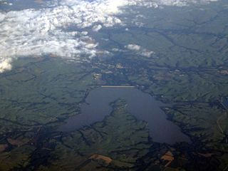
Council Grove is a city and county seat in Morris County, Kansas, United States. It was named after an agreement between European Americans and the Osage Nation about allowing settlers' wagon trains to pass through the area and proceed to the West. Pioneers gathered at a grove of trees so that wagons could band together for their trip west. As of the 2010 census, the city population was 2,182. Council Grove was one of the last stops on the Santa Fe Trail heading southwest. The first European-American settler was Seth Hays, who came to the area in 1847 to trade with the Kaw tribe, which had a reservation established in the area in 1846. Hays was a grandson of Daniel Boone. A post office was established in Council Grove on February 26, 1855.[8] In 1858, the town was officially incorporated by the legislature. Hays also opened a restaurant in 1857, the Hays House, which is said to be the oldest continuously operating restaurant west of the Mississippi River. The town has 13 sites listed on the National Register of Historic Places. One is the Post Office Oak. Travelers left their mail in this designated tree to be picked up by others going in the right direction. General Custer of the United States Army slept here with his troops during the American Civil War, under a large tree known now as the Custer Elm. The National Old Trails Road, also known as the Ocean-to-Ocean Highway, was established in 1912, and was routed through Herington, Delavan, Council Grove. In 1943, German and Italian prisoners of World War II were brought to Kansas and other Midwest states as a means of solving the labor shortage caused by American men serving in the war effort. Large internment camps were established in Kansas: Camp Concordia, Camp Funston (at Fort Riley), Camp Phillips (at Salina under Fort Riley). Fort Riley established 12 smaller branch camps, including Council Grove. Presently, both the Council Grove Reservoir and the City Lake are popular for recreational activities. While both lakes are open to the public and motorized boats, most of the land around the City Lake is privately owned with over three hundred lake houses. Building is restricted on the larger Council Grove Reservoir but there are many well-positioned camp sites. Excellent fishing is found on these lakes as well. Walleye, crappie, white bass, and many more fish are in both the Council Grove Reservoir and the City Lake. en.wikipedia.org/wiki/Council_Grove,_Kansas en.wikipedia.org/wiki/Wikipedia:Text_of_Creative_Commons_... |
| Date | |
| Source | Council Grove, Kansas |
| Author | Ken Lund from Reno, Nevada, USA |
| Camera location | | View this and other nearby images on: OpenStreetMap |
|---|
.jpg¶ms=038.661821_N_-096.487566_E_globe:Earth_type:camera_source:Flickr_&language=en)
Licensing
[edit].jpg&action=edit§ion=2)
- You are free:
- to share – to copy, distribute and transmit the work
- to remix – to adapt the work
- Under the following conditions:
- attribution – You must give appropriate credit, provide a link to the license, and indicate if changes were made. You may do so in any reasonable manner, but not in any way that suggests the licensor endorses you or your use.
- share alike – If you remix, transform, or build upon the material, you must distribute your contributions under the same or compatible license as the original.
| This image was originally posted to Flickr by Ken Lund at https://flickr.com/photos/75683070@N00/14518387303. It was reviewed on 4 December 2015 by FlickreviewR and was confirmed to be licensed under the terms of the cc-by-sa-2.0. |
File history
Click on a date/time to view the file as it appeared at that time.
| Date/Time | Thumbnail | Dimensions | User | Comment | |
|---|---|---|---|---|---|
| current | 03:53, 4 December 2015 | | 4,000 × 3,000 (8.3 MB) | INeverCry (talk | contribs) | Transferred from Flickr via Flickr2Commons |
You cannot overwrite this file.
File usage on Commons
There are no pages that use this file.
.jpg&oldid=896483189)