File:Cosne, environs au sud - Bannay, Saint-Père, Villechaud.png

Original file (1,075 × 574 pixels, file size: 1.55 MB, MIME type: image/png)
Captions
Captions
Summary
[edit]
| Description |
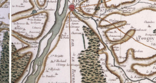
English: 18th century Cassini map of France, detail of the surroundings south of Cosne, in the north-west of the present Nièvre departement, in Burgundy. The town of Cosne is centered on the upper edge of the picture, standing on the right bank of the Loire river that crosses the picture in roughly south-west/-north-east direction. The "road (from Paris) to Lyon through the Bourbonnais" also crosses the picture, coming due south from Cosne. The river reaching Cosne and the Loire from the south-east is the Nohain. After Cosne, the main town is Bannay, showing here on the left bank of the Loire (therefore in the present Cher département). Many small villages and hamlets are indicated on the map. Villechaud (fr) is 4.5 km south of Cosne, about 1 mi west of the road to Lyon and 1/2 mi east of the Loire river. 1/3 of a mile south-west of it is Villefroide, another hamlet.
Français : Carte de Cassini (XVIIIe s.), détail des environs au sud de Cosne, dans le nord-est du département de la Nièvre, en Bourgogne. Cosne est au centre du bord supérieur de la carte, au bord et rive droite de la Loire qui traverse l'image dans une direction approximative S-O/N-E. La rivière qui rejoint Cosne et la Loire par le sud-est est le Nohain.
Après Cosne, une autre grande ville est Bannay, sur la rive gauche de la Loire (donc dans le présent département du Cher). La "route de (Paris à) Lyon par le Bourbonnais" traverse aussi la carte, se dirigeant plein sud depuis Cosne. La carte indique de nombreux villages. Villechaud est à 4,5 km au sud de Cosne à environ 1,6 km à l'ouest de la route de Lyon, et à environ 800 m à l'est de la Loire. Environ 90 m au sud-ouest de Villechaud est le hameau de Villefroide. |
| Date | |
| Source | geoportail.gouv.fr |
| Author | Cassini family (18th century) |
| Camera location | | View this and other nearby images on: OpenStreetMap |
|---|
The coordinates are given for a point roughly at the center of the map detail shown.
Licensing
[edit]
|
This work is in the public domain in its country of origin and other countries and areas where the copyright term is the author's life plus 70 years or fewer. This work is in the public domain in the United States because it was published (or registered with the U.S. Copyright Office) before January 1, 1929. | |
| This file has been identified as being free of known restrictions under copyright law, including all related and neighboring rights. | |
File history
Click on a date/time to view the file as it appeared at that time.
| Date/Time | Thumbnail | Dimensions | User | Comment | |
|---|---|---|---|---|---|
| current | 12:45, 24 April 2017 | | 1,075 × 574 (1.55 MB) | Pueblo89 (talk | contribs) | User created page with UploadWizard |
You cannot overwrite this file.
File usage on Commons
The following page uses this file:
File usage on other wikis
The following other wikis use this file:
- Usage on fr.wikipedia.org
- Usage on zh.wikipedia.org