File:Cosmographia. - Norman B. Leventhal Map Center at the BPL.jpg
Jump to navigation
Jump to search

Size of this preview: 800 × 562 pixels. Other resolutions: 320 × 225 pixels | 640 × 450 pixels | 1,024 × 719 pixels | 1,200 × 843 pixels.
Original file (1,200 × 843 pixels, file size: 478 KB, MIME type: image/jpeg)
Captions
Captions
Add a one-line explanation of what this file represents
Summary
[edit]| Artist |
Lord Nicolas the German (Donnus Nicholas Germanus), cartographer Johann the Blockcutter of Armsheim (Johannes Schnitzer or Johannes de Armsheim), engraver |
| Author | |
| Description |
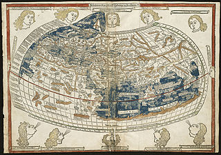
English: The world map from a 1482 edition of Nicolaus Germanus's emendations to Jacobus Angelus's 1406 Latin translation of Maximus Planudes's late-13th century rediscovered Greek manuscripts of Ptolemy's 2nd-century Geography.
BPL Call Number: G1005 .P7 1482 View at the Norman B. Leventhal Map Center Zoom into this map at maps.bpl.org. The classical Greek and Roman world view is known to us through the writings of Claudius Ptolemy, a 2nd century A.D. astronomer, mathematician, and geographer who lived in Alexandria, Egypt. Although his original manuscript no longer exists, various copies survived through the Middle Ages. With the advent of the printing press in the late-15th century, it was one the first geographical texts printed. The first printed editions of Geographia included a world map and 26 regional maps. These maps depicted the extent of the world as known to the ancient Greeks and Romans, which focused on the lands bordering the Mediterranean-- Europe, northern Africa, and western and southern Asia. Despite the disclosure of New World discoveries, such maps still had a strong influence on the Europeans' geographical concept of the world. Unfortunately for the early explorers, this world image underestimated the Earth's circumference and overestimated the breadth of the Eurasian land mass. While the first printed edition of Geographia that included maps was published in Bologna in 1477, the Ulm edition was the first printed north of the Alps and the first to include wood cut printed maps. New and updated versions of Geographia were printed until the mid-19th century. |
| Date | 16 July 1482 |
| Source/Photographer | Norman Bleventhal Map Center on Flickr. |
| Other versions |
|


Licensing
[edit]
This file is licensed under the Creative Commons Attribution 2.0 Generic license.
- You are free:
- to share – to copy, distribute and transmit the work
- to remix – to adapt the work
- Under the following conditions:
- attribution – You must give appropriate credit, provide a link to the license, and indicate if changes were made. You may do so in any reasonable manner, but not in any way that suggests the licensor endorses you or your use.
| This image was originally posted to Flickr by Norman B. Leventhal Map Center at the BPL at https://www.flickr.com/photos/24528911@N05/2709976847. It was reviewed on 2 July 2012 by FlickreviewR and was confirmed to be licensed under the terms of the cc-by-2.0. |
File history
Click on a date/time to view the file as it appeared at that time.
| Date/Time | Thumbnail | Dimensions | User | Comment | |
|---|---|---|---|---|---|
| current | 01:43, 2 July 2012 | | 1,200 × 843 (478 KB) | Dzlinker (talk | contribs) | == {{int:filedesc}} == {{Information |Description=Zoom into [http://maps.bpl.org/id/M10001/ this map] at [http://maps.bpl.org maps.bpl.org]. '''Author:''' Ptolemy '''Publisher:''' Lienhart Holle '''Date:''' 16 July 1482. '''Call Number:''' G1005.1482... |
You cannot overwrite this file.
File usage on Commons
The following 14 pages use this file:
- File:1482 Cosmographia Germanus.JPG
- File:1482 cosmographia nicolaus germanus left.jpg
- File:Bodleian Libraries, Ptolemy, the oikumene, or known World.jpg
- File:Bodleian Libraries, Ptolemy map of the World.jpg
- File:Bodleian Library Auct.P1.4 roll279.1 frame15.jpg
- File:Claudius Ptolemy- The World.jpg
- File:Cosmographia. - Norman B. Leventhal Map Center at the BPL.jpg
- File:Cosmographia – Ulm 1482 - Kungliga Biblioteket - 3276974-thumb.png
- File:Cosmographia – Ulm 1482 - Kungliga Biblioteket - 3276974.tif
- File:Johannes Schnitzer Weltkarte.jpg
- File:PtolemaicMap.jpg
- File:Ptolemy map 15th century.jpg
- File:Ptolomey map.jpg
- File:World of Ptolemy as shown by Johannes de Armsshein - Ulm 1482.png
File usage on other wikis
The following other wikis use this file:
- Usage on en.wikipedia.org