File:Coronavirus infected persons in relation to population of countries (status 22.3).svg
Jump to navigation
Jump to search

Size of this PNG preview of this SVG file: 597 × 600 pixels. Other resolutions: 239 × 240 pixels | 478 × 480 pixels | 765 × 768 pixels | 1,020 × 1,024 pixels | 2,039 × 2,048 pixels | 910 × 914 pixels.
Original file (SVG file, nominally 910 × 914 pixels, file size: 342 KB)
Captions
Captions
Add a one-line explanation of what this file represents
Summary
[edit].svg&action=edit§ion=1)
| Description |
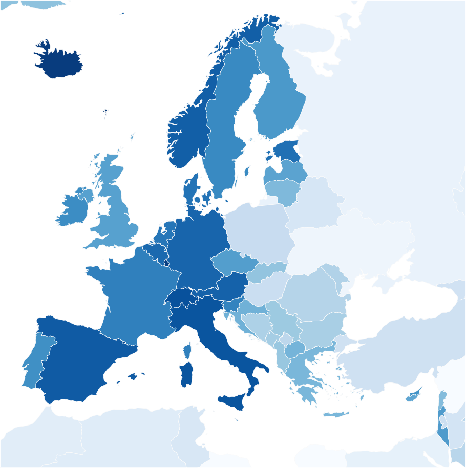
English: Coronavirus infected persons per population of the countries. Status March 22, 2020. Color shades show the ranking, not quantity. |
| Date | |
| Source |
|
| Author |
|
| Permission (Reusing this file) |
|
| This work has been released into the public domain by its author, Peter Christener. This applies worldwide. In some countries this may not be legally possible; if so: Peter Christener grants anyone the right to use this work for any purpose, without any conditions, unless such conditions are required by law. |
File history
Click on a date/time to view the file as it appeared at that time.
| Date/Time | Thumbnail | Dimensions | User | Comment | |
|---|---|---|---|---|---|
| current | 15:26, 22 March 2020 | | 910 × 914 (342 KB) | Pechristener (talk | contribs) | == {{int:filedesc}} == {{Information |description={{en|Coronavirus infected persons per population of the countries. Status March 22, 2020}} |date=2020-03-22 |source= * data of Coronavirus infected persons: www.worldometers.info (March 22, 16:20 CET) * shapes & population data: [https://www.naturalearthdata.com Natural Earth] |author= * Natural Earth: Tom Patterson, Nathaniel Vaughn Kelso and other contributors * Map rendering: Pechristener using [https://qgis.org QGIS]... |
You cannot overwrite this file.
File usage on Commons
There are no pages that use this file.
.svg&oldid=868547990)