File:Corner of village square, Drewsteignton - geograph.org.uk - 1502564.jpg
Jump to navigation
Jump to search
Size of this preview: 450 × 600 pixels. Other resolutions: 180 × 240 pixels | 480 × 640 pixels.
Original file (480 × 640 pixels, file size: 54 KB, MIME type: image/jpeg)
Captions
Captions
Add a one-line explanation of what this file represents
Summary
[edit]
| Description |
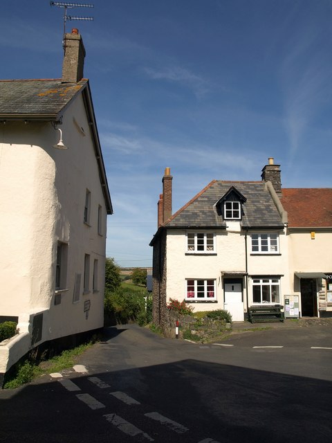
English: Corner of village square, Drewsteignton. A reverse view of the entrance into the square from the north, the lane (Netherton Hill) to the Fingle Brook valley. Here is how the Conservation Area Appraisal at http://www.dartmoor-npa.gov.uk/drews24-31.pdf describes it: "Pinch point: The entrance to the heart of the village from the north is made especially theatrical by the way in which the lane narrows dramatically and the space is filled by the large 3 storey Victorian edifice at the top. The contradiction of scale is a little confusing and makes the joy of the open square a more remarkable surprise for the visitor. It also acts as an effective 'informal' traffic calming measure." On the left is the corner of 1250061. |
| Date | |
| Source | From geograph.org.uk |
| Author | Derek Harper |
| Attribution (required by the license) | Derek Harper / Corner of village square, Drewsteignton / |
| Camera location | | View this and other nearby images on: OpenStreetMap |
|---|
_heading:0.00&language=en)
| Object location | | View this and other nearby images on: OpenStreetMap |
|---|
_heading:0.00&language=en)
Licensing
[edit]

|
This image was taken from the Geograph project collection. See this photograph's page on the Geograph website for the photographer's contact details. The copyright on this image is owned by Derek Harper and is licensed for reuse under the Creative Commons Attribution-ShareAlike 2.0 license.
|
This file is licensed under the Creative Commons Attribution-Share Alike 2.0 Generic license.
Attribution: Derek Harper
- You are free:
- to share – to copy, distribute and transmit the work
- to remix – to adapt the work
- Under the following conditions:
- attribution – You must give appropriate credit, provide a link to the license, and indicate if changes were made. You may do so in any reasonable manner, but not in any way that suggests the licensor endorses you or your use.
- share alike – If you remix, transform, or build upon the material, you must distribute your contributions under the same or compatible license as the original.
File history
Click on a date/time to view the file as it appeared at that time.
| Date/Time | Thumbnail | Dimensions | User | Comment | |
|---|---|---|---|---|---|
| current | 20:19, 2 March 2011 | | 480 × 640 (54 KB) | GeographBot (talk | contribs) | == {{int:filedesc}} == {{Information |description={{en|1=Corner of village square, Drewsteignton A reverse view of the entrance into the square from the north, the lane (Netherton Hill) to the Fingle Brook valley. Here is how the Conservation Area Apprais |
You cannot overwrite this file.
File usage on Commons
There are no pages that use this file.