File:Copper-alloy barrel padlock fragment (FindID 778937).jpg
Jump to navigation
Jump to search

Size of this preview: 606 × 600 pixels. Other resolutions: 242 × 240 pixels | 485 × 480 pixels | 776 × 768 pixels | 1,035 × 1,024 pixels | 2,069 × 2,048 pixels | 3,448 × 3,413 pixels.
Original file (3,448 × 3,413 pixels, file size: 1.7 MB, MIME type: image/jpeg)
Captions
Captions
Add a one-line explanation of what this file represents
Summary
[edit].jpg&action=edit§ion=1)
| Copper-alloy barrel padlock fragment | |||
|---|---|---|---|
| Photographer |
Kent County Council, Walter (Jo) Ahmet, 2016-04-14 18:19:12 |
||
| Title |
Copper-alloy barrel padlock fragment |
||
| Description |
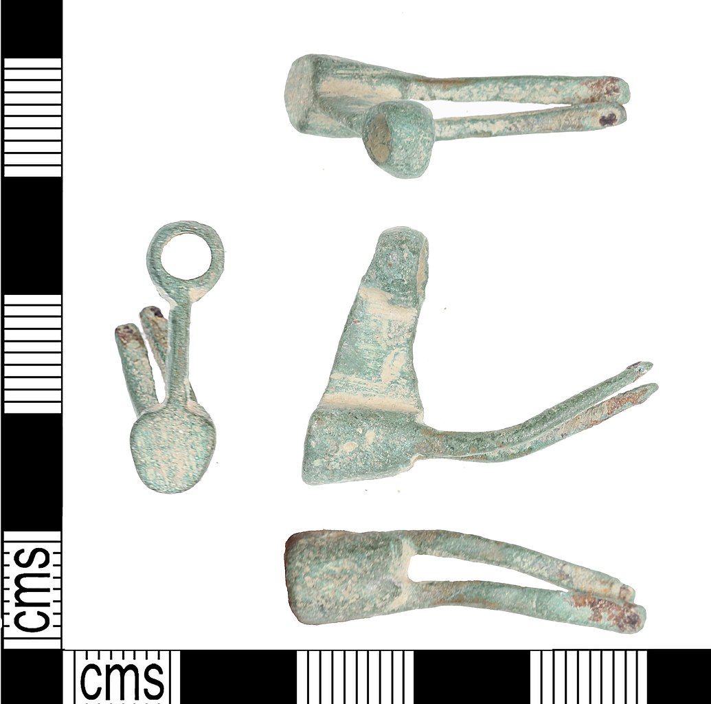
English: An incomplete copper alloy Medieval cylindrical barrel padlock mechanism, c.1200-1400AD. The padlock mechanism consists of a two cylindrical sections connected by a rectangular central section. The upper cylindrical section has a circular perforation, the lower is solid. The rectangular projection has a small circular projection in its centre.The solid cylindrical section has two rectangular projections which have circular perforations at the terminals and show evidence of solder on both the upper and lower face.
Measurements: 26.57mm in length, 21.76mm in width, 7.43mm thick and 5.57g in wieght |
||
| Depicted place | (County of findspot) Kent | ||
| Date | between 1200 and 1400 | ||
| Accession number |
FindID: 778937 Old ref: KENT-FCD35D Filename: KENTFCD35D.jpg |
||
| Credit line |
|
||
| Source |
https://finds.org.uk/database/ajax/download/id/563454 Catalog: https://finds.org.uk/database/images/image/id/563454/recordtype/artefacts archive copy at the Wayback Machine Artefact: https://finds.org.uk/database/artefacts/record/id/778937 |
||
| Permission (Reusing this file) |
Attribution License version 2.0 (verified 25 November 2020) | ||
| Object location | | View this and other nearby images on: OpenStreetMap |
|---|
.jpg¶ms=051.241500_N_0001.080460_E_globe:Earth_class:object_type:object__&language=en)
Licensing
[edit].jpg&action=edit§ion=2)
This file is licensed under the Creative Commons Attribution 2.0 Generic license.
Attribution: Kent County Council
- You are free:
- to share – to copy, distribute and transmit the work
- to remix – to adapt the work
- Under the following conditions:
- attribution – You must give appropriate credit, provide a link to the license, and indicate if changes were made. You may do so in any reasonable manner, but not in any way that suggests the licensor endorses you or your use.
File history
Click on a date/time to view the file as it appeared at that time.
| Date/Time | Thumbnail | Dimensions | User | Comment | |
|---|---|---|---|---|---|
| current | 02:07, 10 February 2019 | | 3,448 × 3,413 (1.7 MB) | Fæ (talk | contribs) | Portable Antiquities Scheme, KENT, FindID: 778937, medieval, page 4196, batch count 660 |
You cannot overwrite this file.
File usage on Commons
The following page uses this file:
.jpg)
.jpg&oldid=868171632)