File:Coordenadas de Barinas.svg
Jump to navigation
Jump to search

Size of this PNG preview of this SVG file: 800 × 361 pixels. Other resolutions: 320 × 144 pixels | 640 × 289 pixels | 1,024 × 462 pixels | 1,280 × 577 pixels | 2,560 × 1,155 pixels | 2,689 × 1,213 pixels.
Original file (SVG file, nominally 2,689 × 1,213 pixels, file size: 396 KB)
Captions
Captions
Add a one-line explanation of what this file represents
Summary
[edit]
| Description |
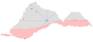
Español: Mapa con el centro geográfico del Estado Barinas y sus orientaciones. |
| Date | |
| Source | Own work |
| Author | Carlos Jesús Vitorino García |
Licensing
[edit]
I, the copyright holder of this work, hereby publish it under the following license:
This file is licensed under the Creative Commons Attribution-Share Alike 4.0 International license.
- You are free:
- to share – to copy, distribute and transmit the work
- to remix – to adapt the work
- Under the following conditions:
- attribution – You must give appropriate credit, provide a link to the license, and indicate if changes were made. You may do so in any reasonable manner, but not in any way that suggests the licensor endorses you or your use.
- share alike – If you remix, transform, or build upon the material, you must distribute your contributions under the same or compatible license as the original.
File history
Click on a date/time to view the file as it appeared at that time.
| Date/Time | Thumbnail | Dimensions | User | Comment | |
|---|---|---|---|---|---|
| current | 21:27, 18 October 2019 | | 2,689 × 1,213 (396 KB) | Carlos Jesús Vitorino García (talk | contribs) | mejorado |
| 16:08, 18 October 2019 |  | 2,689 × 1,213 (380 KB) | Carlos Jesús Vitorino García (talk | contribs) | User created page with UploadWizard |
You cannot overwrite this file.
File usage on Commons
There are no pages that use this file.