File:Cookham station geograph-3086572-by-Ben-Brooksbank.jpg
Jump to navigation
Jump to search

Size of this preview: 800 × 493 pixels. Other resolutions: 320 × 197 pixels | 640 × 395 pixels | 897 × 553 pixels.
Original file (897 × 553 pixels, file size: 439 KB, MIME type: image/jpeg)
Captions
Captions
Add a one-line explanation of what this file represents
Summary
[edit]
| Description |
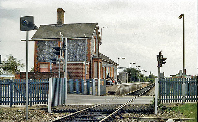
English: Cookham station. View southward at the B4447 level-crossing, towards Maidenhead: ex-GW branch from Maidenhead, which until 4/5/70 ran to High Wycombe with a separate shuttle Bourne End - Marlow. Bourne End - High Wycombe was then closed and the service has run Maidenhead - Marlow. |
| Date | Taken on 18 May 1986 |
| Source | From geograph.org.uk |
| Author | Ben Brooksbank |
| Permission (Reusing this file) |
Creative Commons Attribution Share-alike license 2.0 |
| Attribution (required by the license) | Ben Brooksbank / Cookham station / |
| Camera location | | View this and other nearby images on: OpenStreetMap |
|---|
Licensing
[edit]

|
This image was taken from the Geograph project collection. See this photograph's page on the Geograph website for the photographer's contact details. The copyright on this image is owned by Ben Brooksbank and is licensed for reuse under the Creative Commons Attribution-ShareAlike 2.0 license.
|
This file is licensed under the Creative Commons Attribution-Share Alike 2.0 Generic license.
Attribution: Ben Brooksbank
- You are free:
- to share – to copy, distribute and transmit the work
- to remix – to adapt the work
- Under the following conditions:
- attribution – You must give appropriate credit, provide a link to the license, and indicate if changes were made. You may do so in any reasonable manner, but not in any way that suggests the licensor endorses you or your use.
- share alike – If you remix, transform, or build upon the material, you must distribute your contributions under the same or compatible license as the original.
File history
Click on a date/time to view the file as it appeared at that time.
| Date/Time | Thumbnail | Dimensions | User | Comment | |
|---|---|---|---|---|---|
| current | 12:25, 2 September 2012 | | 897 × 553 (439 KB) | Chevin (talk | contribs) | == {{int:filedesc}} == {{Information |Description={{en|1='''Cookham station.'''<br/> View southward at the B4447 level-crossing, towards Maidenhead: ex-GW branch from Maidenhead, which until 4/5/70 ran to High Wycombe with a separate shuttle Bourne End... |
You cannot overwrite this file.
File usage on Commons
The following page uses this file:
File usage on other wikis
The following other wikis use this file:
- Usage on en.wikipedia.org