File:Contact Period lowland Guatemala.gif
Jump to navigation
Jump to search
Size of this preview: 787 × 600 pixels. Other resolutions: 315 × 240 pixels | 630 × 480 pixels | 828 × 631 pixels.
Original file (828 × 631 pixels, file size: 224 KB, MIME type: image/gif)
Captions
Captions
Add a one-line explanation of what this file represents
Summary
[edit]
| Description |
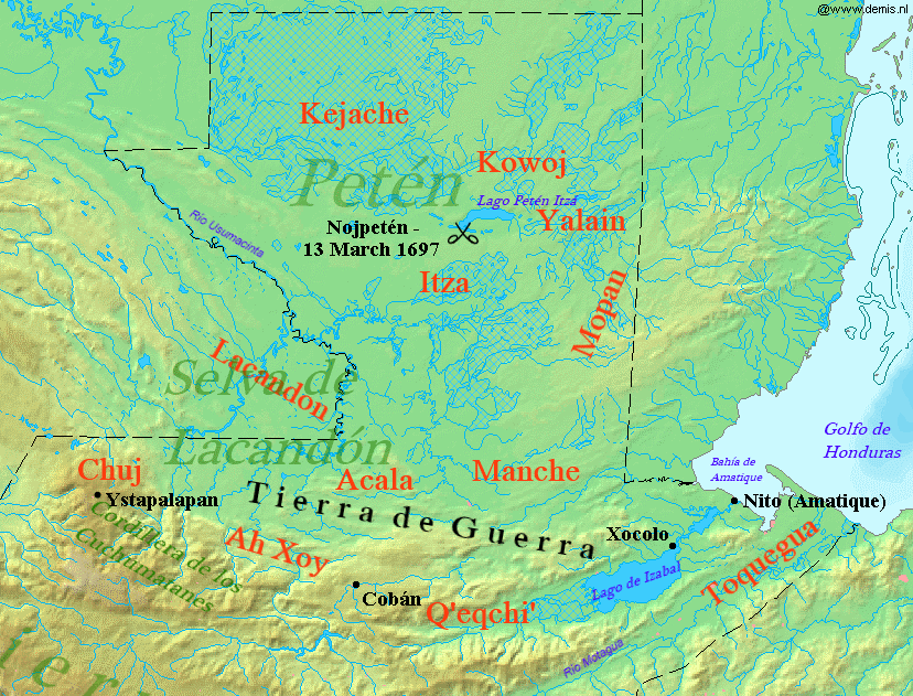
English: Map of Contact Period lowland Guatemala, 16-17th century.
Español: Mapa de las tierras bajas del norte de Guatemala durante el periodo de contacto, siglos XVI-XVII. |
| Date | |
| Source |
Own work using:
|
| Author |
|
| This is a retouched picture, which means that it has been digitally altered from its original version. Modifications: Added indigenous territories and geographical locations. The original can be viewed here: Map of Guatemala Demis.png:
|
Licensing
[edit]
I, the copyright holder of this work, hereby publish it under the following license:
This file is licensed under the Creative Commons Attribution-Share Alike 3.0 Unported license.
- You are free:
- to share – to copy, distribute and transmit the work
- to remix – to adapt the work
- Under the following conditions:
- attribution – You must give appropriate credit, provide a link to the license, and indicate if changes were made. You may do so in any reasonable manner, but not in any way that suggests the licensor endorses you or your use.
- share alike – If you remix, transform, or build upon the material, you must distribute your contributions under the same or compatible license as the original.
File history
Click on a date/time to view the file as it appeared at that time.
| Date/Time | Thumbnail | Dimensions | User | Comment | |
|---|---|---|---|---|---|
| current | 17:54, 15 October 2013 | | 828 × 631 (224 KB) | Simon Burchell (talk | contribs) | +Ah Xoy text |
| 20:48, 31 January 2012 |  | 828 × 631 (227 KB) | Simon Burchell (talk | contribs) | +Acala text | |
| 00:00, 30 January 2012 |  | 828 × 631 (226 KB) | Simon Burchell (talk | contribs) | + Q'eqchi' text | |
| 23:52, 19 January 2012 |  | 828 × 631 (226 KB) | Simon Burchell (talk | contribs) | {{Information |Description={{en|1=Map of Contact Period lowland Guatemala, 16-17th century.}} {{es|1=Mapa de las tierras bajas del norte de Guatemala durante el periodo de contacto, siglos XVI-XVII.}} |Source={{own}} |Date=2012-01-19 |Author= [[User:Simon |
You cannot overwrite this file.
File usage on Commons
The following page uses this file:
File usage on other wikis
The following other wikis use this file:
- Usage on ar.wikipedia.org
- Usage on en.wikipedia.org
- Usage on fr.wikipedia.org
- Usage on id.wikipedia.org
- Usage on it.wikipedia.org
- Usage on ja.wikipedia.org
- Usage on pl.wiktionary.org
- Usage on pt.wikipedia.org