File:Connell Cemetery TxHM (25511116541).jpg

Original file (1,923 × 2,928 pixels, file size: 2.71 MB, MIME type: image/jpeg)
Captions
Captions
Summary
[edit].jpg&action=edit§ion=1)
| Description |
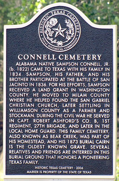
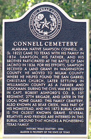
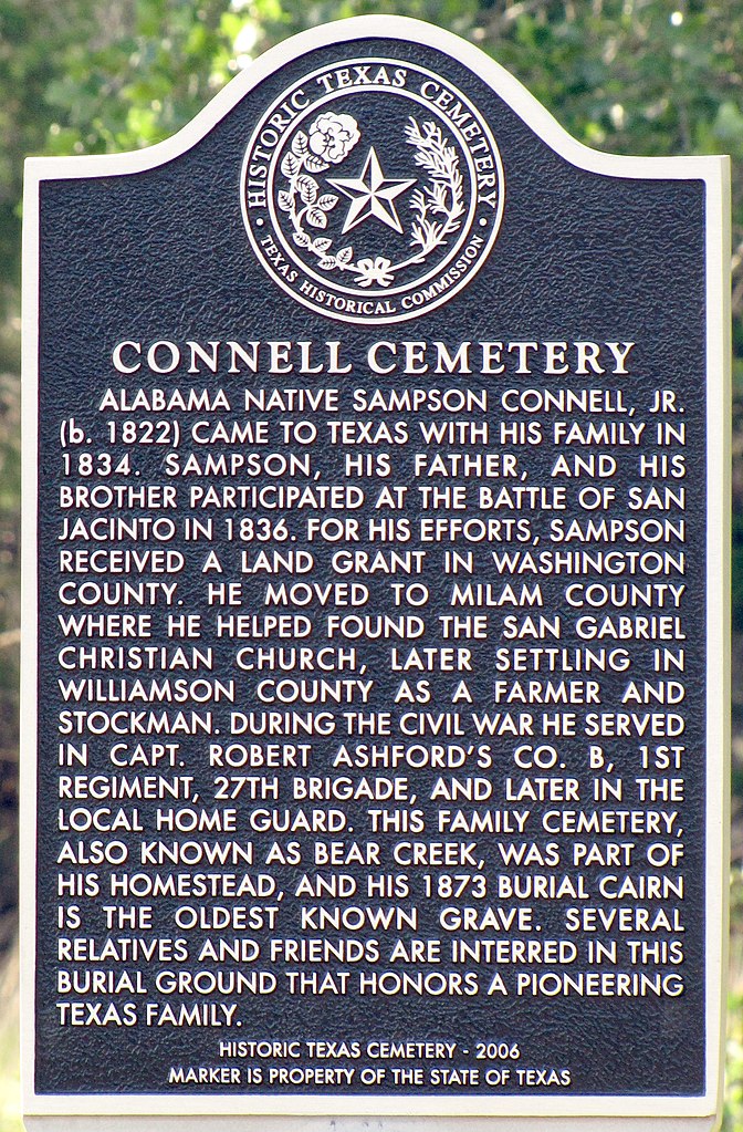
Alabama native Sampson Connell, Jr. (b. 1822) came to Texas with his family in 1834. Sampson, his father, and his brother participated at the Battle of San Jacinto in 1836. For his efforts, Sampson received a land grant in Washington County. He moved to Milam County where he helped found the San Gabriel Christian Church, later settling in Williamson County as a farmer and stockman. During the Civil War he served in Capt. Robert Ashford's Co. B, 1st Regiment, 27th Brigade, and later in the local Home Guard. This family cemetery, also known as Bear Creek, was part of his homestead, and his 1873 burial cairn is the oldest known grave. Several relatives and friends are interred in this burial ground that honors a pioneering Texas family. Historic Texas Cemetery-2006 Marker is Property of the State of Texas (This image represents an Open Plaques entry) |
| Date | |
| Source | Connell Cemetery TxHM |
| Author | QuesterMark from Where the West Begins, United States |
| Camera location | | View this and other nearby images on: OpenStreetMap |
|---|
.jpg¶ms=030.742383_N_-097.944712_E_globe:Earth_type:camera_source:Flickr_&language=en)
Licensing
[edit].jpg&action=edit§ion=2)
- You are free:
- to share – to copy, distribute and transmit the work
- to remix – to adapt the work
- Under the following conditions:
- attribution – You must give appropriate credit, provide a link to the license, and indicate if changes were made. You may do so in any reasonable manner, but not in any way that suggests the licensor endorses you or your use.
- share alike – If you remix, transform, or build upon the material, you must distribute your contributions under the same or compatible license as the original.
| This image was originally posted to Flickr by QuesterMark at https://flickr.com/photos/52855156@N00/25511116541 (archive). It was reviewed on 7 November 2018 by FlickreviewR 2 and was confirmed to be licensed under the terms of the cc-by-sa-2.0. |
File history
Click on a date/time to view the file as it appeared at that time.
| Date/Time | Thumbnail | Dimensions | User | Comment | |
|---|---|---|---|---|---|
| current | 15:32, 7 November 2018 | | 1,923 × 2,928 (2.71 MB) | Jnicho02 (talk | contribs) | Transferred from Flickr via #flickr2commons |
You cannot overwrite this file.
File usage on Commons
The following page uses this file:
File usage on other wikis
The following other wikis use this file:
- Usage on www.wikidata.org
.jpg&oldid=895987753)