File:Compiègne - Musée du cloître Saint-Corneille - Maquette de l'abbaye.jpg
Jump to navigation
Jump to search
Size of this preview: 800 × 454 pixels. Other resolutions: 320 × 182 pixels | 640 × 363 pixels | 1,024 × 582 pixels | 1,280 × 727 pixels | 2,560 × 1,454 pixels | 4,900 × 2,783 pixels.
Original file (4,900 × 2,783 pixels, file size: 1.67 MB, MIME type: image/jpeg)
Captions
Captions
Add a one-line explanation of what this file represents
Summary
[edit]
| Description |
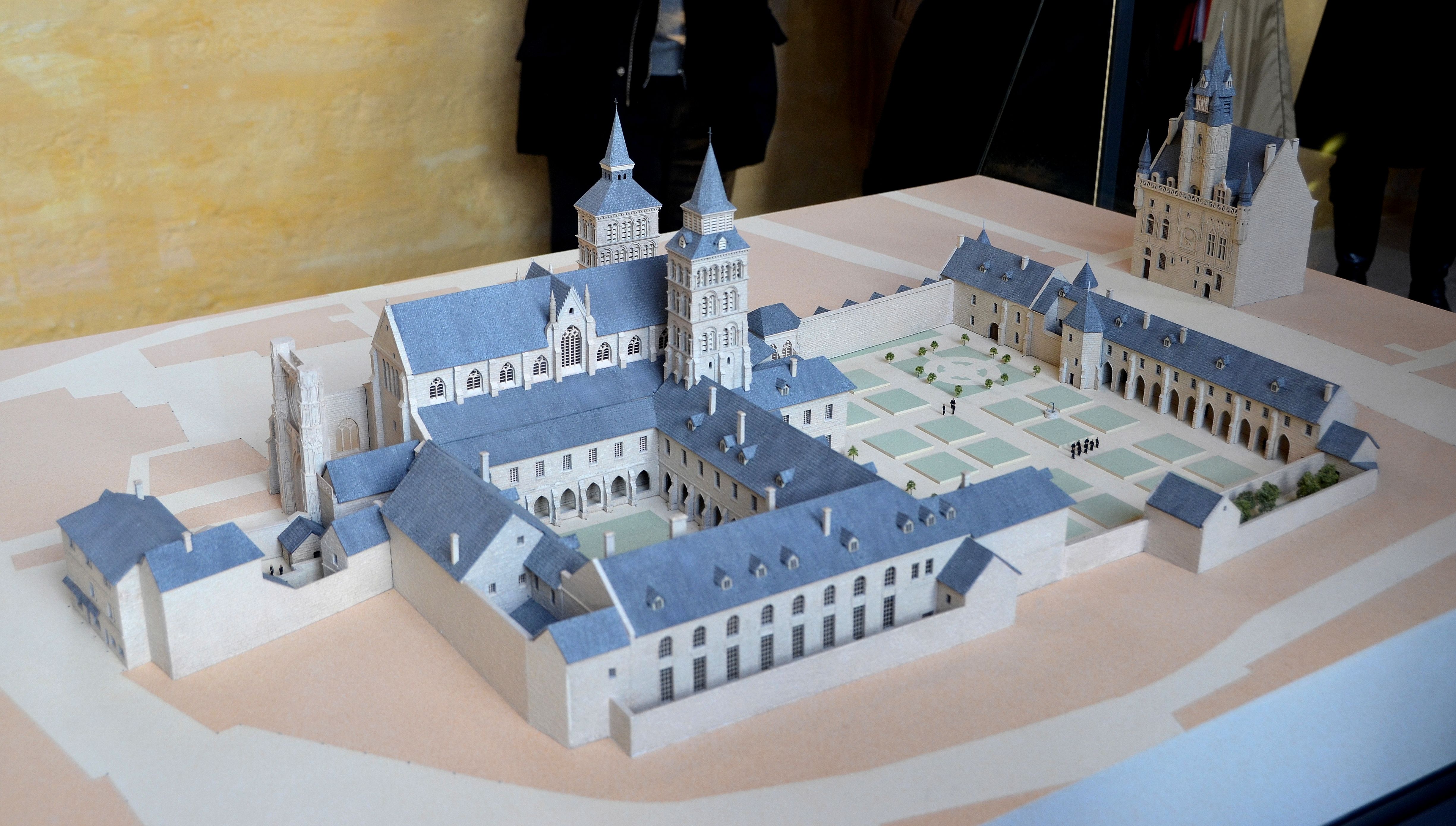
English: Compiègne - Musée du cloître Saint-Corneille - Maquette de l'abbaye
L'abbaye Saint-Corneille est fondée en 877 par l’empereur Charles le Chauve et dotée de précieuses reliques qui font la réputation et la richesse de l'abbaye. Les rois de France viennent séjourner à Compiègne et comblent d'attentions l’abbaye, où certains y sont sacrés : Louis II le Bègue (877), Eude (888), Louis V (979) et Hugues II (1017) et plusieurs y sont enterrés : Louis II le Bègue (879), Louis V (987) et Hugues II (1025). Ayant remplacé le collège des chanoines au XIIe siècle, les Bénédictins font prospérer l'abbaye qui dépend directement du pape et non de l'évêque de Soissons. Dès 1483, l'abbaye tombe en commende, ses abbés ne sont plus élus par la communauté, mais désignés par le roi. En 1656, Saint-Corneille tombe sous la coupe de l'abbaye du Val-de-Grâce ; désormais, sans abbé, les prérogatives séculaires de l'abbaye sont peu à peu battues en brèche par les évêques de Soissons. La Révolution lui est fatale : la communauté est dissoute en 1790. L'église abbatiale est rapidement destinée à la vente, elle est alors profanée et pillée. L’édifice concédé à l'armée devient une fabrique de salpêtre puis un magasin à fourrage. Cédée à la Ville par le ministère de la Guerre, Saint-Corneille est démolie afin de percer la rue qui porte aujourd'hui son nom et où seul le cloître demeure encore debout. |
| Date | Taken on 16 December 2012, 12:04:56 |
| Source | https://www.flickr.com/photos/78775886@N06/8437643086/ |
| Author | Morio60 |
| Camera location | | View this and other nearby images on: OpenStreetMap |
|---|
Licensing
[edit]
This file is licensed under the Creative Commons Attribution-Share Alike 2.0 Generic license.
- You are free:
- to share – to copy, distribute and transmit the work
- to remix – to adapt the work
- Under the following conditions:
- attribution – You must give appropriate credit, provide a link to the license, and indicate if changes were made. You may do so in any reasonable manner, but not in any way that suggests the licensor endorses you or your use.
- share alike – If you remix, transform, or build upon the material, you must distribute your contributions under the same or compatible license as the original.
| This image was originally posted to Flickr by Morio60 at https://flickr.com/photos/78775886@N06/8437643086. It was reviewed on 7 May 2021 by FlickreviewR 2 and was confirmed to be licensed under the terms of the cc-by-sa-2.0. |
File history
Click on a date/time to view the file as it appeared at that time.
| Date/Time | Thumbnail | Dimensions | User | Comment | |
|---|---|---|---|---|---|
| current | 15:02, 7 May 2021 | | 4,900 × 2,783 (1.67 MB) | Edelseider (talk | contribs) | Uploaded a work by Morio60 from https://www.flickr.com/photos/78775886@N06/8437643086/ with UploadWizard |
You cannot overwrite this file.
File usage on Commons
There are no pages that use this file.