File:Comparison satellite navigation orbits-mk.svg
Jump to navigation
Jump to search

Size of this PNG preview of this SVG file: 512 × 512 pixels. Other resolutions: 240 × 240 pixels | 480 × 480 pixels | 768 × 768 pixels | 1,024 × 1,024 pixels | 2,048 × 2,048 pixels.
Original file (SVG file, nominally 512 × 512 pixels, file size: 268 KB)
Captions
Captions
Add a one-line explanation of what this file represents
Summary
[edit]| Description |
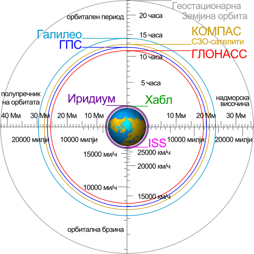
English: Comparison of satellite navigation orbits and other objects that orbit the Earth, with labels in Macedonian. Македонски: Споредба на орбитите за сателитско наведување и други тела што кружат околу Земјата. |
|
| Date | ||
| Source |
|
|
| Author | Cmglee | |
| Other versions |
[] English: Animated Español: Animada Македонски: Анимирано Русский: Мультипликация Українська: Анімація
English: Static Македонски: Обична слика Русский: Обычная картинка Українська: Статичне зображення
|


Licensing
[edit]
This file is licensed under the Creative Commons Attribution-Share Alike 3.0 Unported license.
- You are free:
- to share – to copy, distribute and transmit the work
- to remix – to adapt the work
- Under the following conditions:
- attribution – You must give appropriate credit, provide a link to the license, and indicate if changes were made. You may do so in any reasonable manner, but not in any way that suggests the licensor endorses you or your use.
- share alike – If you remix, transform, or build upon the material, you must distribute your contributions under the same or compatible license as the original.
File history
Click on a date/time to view the file as it appeared at that time.
| Date/Time | Thumbnail | Dimensions | User | Comment | |
|---|---|---|---|---|---|
| current | 07:48, 11 November 2022 | | 512 × 512 (268 KB) | Bjankuloski06 (talk | contribs) | Reverted to version as of 09:07, 16 July 2021 (UTC) |
| 07:32, 11 November 2022 |  | 512 × 512 (279 KB) | Bjankuloski06 (talk | contribs) | Added words | |
| 09:07, 16 July 2021 |  | 512 × 512 (268 KB) | Bjankuloski06 (talk | contribs) | Reverted to version as of 12:36, 19 July 2014 (UTC) | |
| 08:48, 16 July 2021 |  | 512 × 512 (78 KB) | Bjankuloski06 (talk | contribs) | Updated version | |
| 12:36, 19 July 2014 |  | 512 × 512 (268 KB) | Bjankuloski06 (talk | contribs) | Uploading the corrected version. Previous upload was of an old, draft-version. | |
| 12:32, 19 July 2014 |  | 512 × 512 (44 KB) | Bjankuloski06 (talk | contribs) | User created page with UploadWizard |
You cannot overwrite this file.
File usage on Commons
The following 4 pages use this file: