File:Communes of Tachelhit.png
Jump to navigation
Jump to search

Size of this preview: 686 × 599 pixels. Other resolutions: 275 × 240 pixels | 549 × 480 pixels | 879 × 768 pixels | 1,149 × 1,004 pixels.
Original file (1,149 × 1,004 pixels, file size: 284 KB, MIME type: image/png)
Captions
Captions
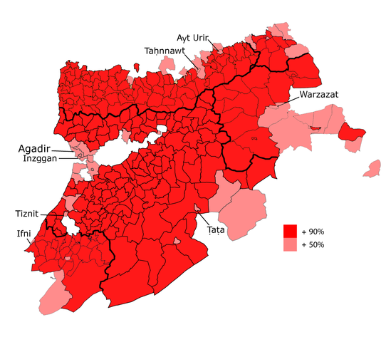
Communes or municipalities where Tachelhit is majority in Morocco (year 2014)
Summary
[edit]
| Description |
English: Communes or municipalities in Morocco where Tachelhit speakers are more than the half of the population. This work is based on the official counting (2014) by the RGPH (http://rgphentableaux.hcp.ma/) and based on the work of the research center Tafra (http://tafra.ma/ya-til-un-vote-tachelhit/)
Taclḥit : Tigrawin n tmazirt n Lmɣrib nna ɣ ttuysawaln Taclḥit dar uggar n uzgn n middn. Tawlaft ad tusi iɣbula nns zɣ uṣiḍn lli tskr RGPH ɣ usggʷas n 2014 (http://rgphentableaux.hcp.ma/) d yusi iɣbula nns ula zɣ twuri n ammas n ucnubbc Tafra (http://tafra.ma/ya-til-un-vote-tachelhit/) |
| Date | |
| Source | Own work |
| Author | Ayour |
Licensing
[edit]
I, the copyright holder of this work, hereby publish it under the following license:
This file is licensed under the Creative Commons Attribution-Share Alike 4.0 International license.
- You are free:
- to share – to copy, distribute and transmit the work
- to remix – to adapt the work
- Under the following conditions:
- attribution – You must give appropriate credit, provide a link to the license, and indicate if changes were made. You may do so in any reasonable manner, but not in any way that suggests the licensor endorses you or your use.
- share alike – If you remix, transform, or build upon the material, you must distribute your contributions under the same or compatible license as the original.
File history
Click on a date/time to view the file as it appeared at that time.
| Date/Time | Thumbnail | Dimensions | User | Comment | |
|---|---|---|---|---|---|
| current | 00:53, 14 February 2021 | | 1,149 × 1,004 (284 KB) | AyourAchtouk (talk | contribs) | + Borders of regions |
| 00:07, 14 February 2021 |  | 1,149 × 1,004 (272 KB) | AyourAchtouk (talk | contribs) | Uploaded own work with UploadWizard |
You cannot overwrite this file.
File usage on Commons
The following page uses this file:
File usage on other wikis
The following other wikis use this file:
- Usage on ary.wikipedia.org
- Usage on en.wikipedia.org
- Usage on fr.wikipedia.org
- Usage on it.wikipedia.org
- Usage on kab.wikipedia.org
- Usage on shi.wikipedia.org
- Usage on zgh.wikipedia.org