File:Commonwealth and Anglosphere.svg
Jump to navigation
Jump to search

Size of this PNG preview of this SVG file: 800 × 406 pixels. Other resolutions: 320 × 162 pixels | 640 × 325 pixels | 1,024 × 520 pixels | 1,280 × 650 pixels | 2,560 × 1,300 pixels | 2,754 × 1,398 pixels.
Original file (SVG file, nominally 2,754 × 1,398 pixels, file size: 1.05 MB)
Captions
Captions
Commonwealth and the Anglosphere

|
This file may be updated to reflect new information. If you wish to use a specific version of the file without it being overwritten, please upload the required version as a separate file. |

Summary
[edit]
| Description |
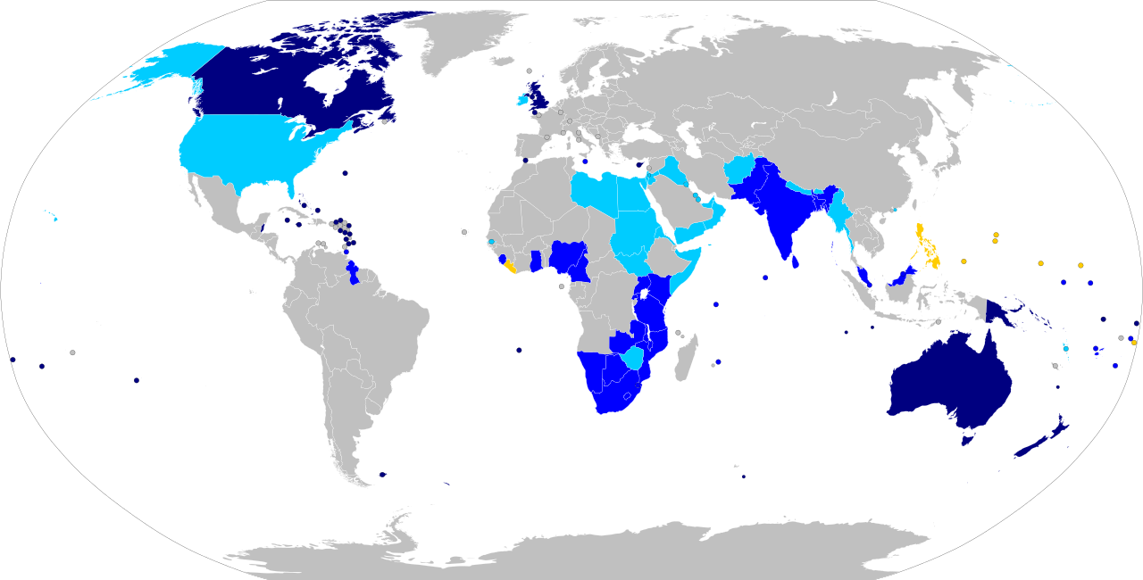
English: Map of the countries that made up the former British Empire, as well as other English-speaking countries that were not part of the British Empire.[clarification needed]
Commonwealth realms where Elizabeth II remains head of state Commonwealth of Nations members (all except Rwanda and Mozambique formerly parts of the British Empire) Countries that were formerly part of the British Empire but currently not a member of the Commonwealth Countries formerly under United States rule or influence that have adopted English as one of their main languages |
| Date | |
| Source | Own work |
| Author | Bearsmalaysia |
Licensing
[edit]
I, the copyright holder of this work, hereby publish it under the following license:
This file is licensed under the Creative Commons Attribution-Share Alike 3.0 Unported license.
- You are free:
- to share – to copy, distribute and transmit the work
- to remix – to adapt the work
- Under the following conditions:
- attribution – You must give appropriate credit, provide a link to the license, and indicate if changes were made. You may do so in any reasonable manner, but not in any way that suggests the licensor endorses you or your use.
- share alike – If you remix, transform, or build upon the material, you must distribute your contributions under the same or compatible license as the original.
| Annotations | This image is annotated: View the annotations at Commons |
Any autoconfirmed user can overwrite this file from the same source. Please ensure that overwrites comply with the guideline.
File history
Click on a date/time to view the file as it appeared at that time.
| Date/Time | Thumbnail | Dimensions | User | Comment | |
|---|---|---|---|---|---|
| current | 04:13, 7 December 2021 | | 2,754 × 1,398 (1.05 MB) | Getsnoopy (talk | contribs) | Removed the responsive flag so that it matches BlankMap.svg. |
| 04:10, 7 December 2021 |  | 512 × 260 (1.05 MB) | Getsnoopy (talk | contribs) | Updated to use the latest BlankMap.svg. | |
| 11:43, 5 June 2021 |  | 512 × 263 (788 KB) | Wjkim1008 (talk | contribs) | Addition of some countries. References were made to each country's historical relationship with the United Kingdom (File:Commonwealth of Nations prospective members (simple).png). | |
| 23:28, 26 December 2017 |  | 863 × 443 (1.59 MB) | Renamed user OCfxJKu7j2 (talk | contribs) | Added Commonwealth Realms distinction | |
| 16:11, 26 December 2013 |  | 863 × 443 (1.59 MB) | Derkommander0916 (talk | contribs) | Changed colour for Gambia. Gambia left the Commonwealth in October 2013. | |
| 14:30, 24 July 2013 |  | 863 × 443 (1.59 MB) | Bearsmalaysia (talk | contribs) | User created page with UploadWizard |
You cannot overwrite this file.
File usage on Commons
The following 3 pages use this file:
File usage on other wikis
The following other wikis use this file:
- Usage on el.wikipedia.org
- Usage on es.wikipedia.org
- Usage on it.wikipedia.org
- Usage on nl.wikipedia.org
- Usage on sr.wikipedia.org
- Usage on tr.wikipedia.org