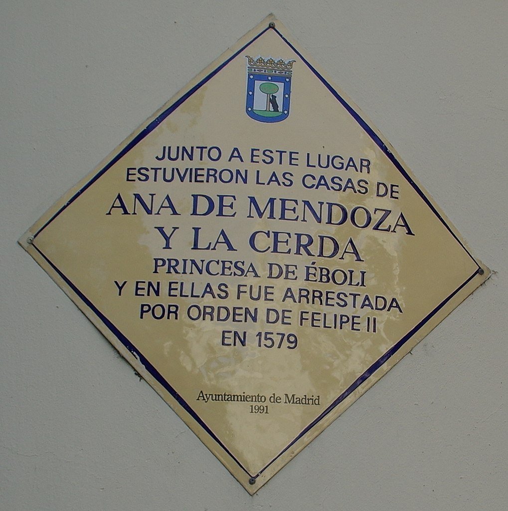
File:Commemorative plaque to Ana de Mendoza de la Cerda.jpg
From Wikimedia Commons, the free media repository
Jump to navigation
Jump to search
Size of this preview: 597 × 600 pixels. Other resolutions: 239 × 240 pixels | 478 × 480 pixels | 764 × 768 pixels | 1,019 × 1,024 pixels | 1,303 × 1,309 pixels.
Original file (1,303 × 1,309 pixels, file size: 1.02 MB, MIME type: image/jpeg)
File information
Structured data
Captions
Summary
[edit]DescriptionCommemorative plaque to Ana de Mendoza de la Cerda.jpg | VIEW : ®'s / DiDi / RM / Ð 6K / ┼ : MADRID CALLE MAYOR_EDIFICIOS | |||
Date | Taken on 9 May 2015 | |||
Source | https://www.panoramio.com/photo/119478553 | |||
Author | Concepcion AMAT ORTA… | |||
Permission (Reusing this file) |
This file is licensed under the Creative Commons Attribution 3.0 Unported license. Attribution: Concepcion AMAT ORTA…
|
|||
Other versions |
|
|||
Panoramio Tags InfoField | Madrid , 2015 , Calle Mayor , Comunidad de Madrid , Edificio , Edificio Singular , Instituto Italiano de Cultura , Madrid , Spain |
Camera location | 40° 24′ 55.45″ N, 3° 42′ 48.56″ W | View this and other nearby images on: OpenStreetMap | 40.415403; -3.713490 |
---|
File history
Click on a date/time to view the file as it appeared at that time.
Date/Time | Thumbnail | Dimensions | User | Comment | |
---|---|---|---|---|---|
current | 15:05, 28 February 2018 | 1,303 × 1,309 (1.02 MB) | Triplecaña (talk | contribs) | File:VIEW , ®'s - DiDi - RM - Ð 6K - ┼ , MADRID CALLE MAYOR EDIFICIOS - panoramio (49).jpg cropped 78 % horizontally and 67 % vertically using CropTool with lossless mode. |
You cannot overwrite this file.
File usage on Commons
The following 2 pages use this file:
File usage on other wikis
The following other wikis use this file:
- Usage on ca.wikipedia.org
- Usage on es.wikipedia.org
- Usage on gl.wikipedia.org
- Usage on www.wikidata.org
Metadata
This file contains additional information such as Exif metadata which may have been added by the digital camera, scanner, or software program used to create or digitize it. If the file has been modified from its original state, some details such as the timestamp may not fully reflect those of the original file. The timestamp is only as accurate as the clock in the camera, and it may be completely wrong.
Camera manufacturer | RICOH IMAGING COMPANY, LTD. |
---|---|
Camera model | PENTAX K-3 |
Exposure time | 1/250 sec (0.004) |
F-number | f/7.1 |
ISO speed rating | 200 |
Date and time of data generation | 08:51, 9 May 2015 |
Lens focal length | 18 mm |
Latitude | 40° 24′ 55.45″ N |
Longitude | 3° 42′ 48.56″ W |
Altitude | 529.1 meters above sea level |
Orientation | Normal |
Horizontal resolution | 300 dpi |
Vertical resolution | 300 dpi |
Software used | PENTAX K-3 Ver. 1.00 |
File change date and time | 08:51, 9 May 2015 |
Y and C positioning | Co-sited |
Exposure Program | Normal program |
Exif version | 2.3 |
Date and time of digitizing | 08:51, 9 May 2015 |
Meaning of each component |
|
APEX exposure bias | 0 |
Metering mode | Pattern |
Flash | Flash did not fire, compulsory flash suppression |
Supported Flashpix version | 1 |
Color space | sRGB |
Sensing method | One-chip color area sensor |
File source | Digital still camera |
Scene type | A directly photographed image |
Custom image processing | Normal process |
Exposure mode | Auto exposure |
White balance | Auto white balance |
Focal length in 35 mm film | 27 mm |
Scene capture type | Standard |
Contrast | Hard |
Saturation | Normal |
Sharpness | Hard |
Subject distance range | Close view |
GPS time (atomic clock) | 08:51 |
Satellites used for measurement | 08 |
Receiver status | Measurement in progress |
Measurement mode | 3-dimensional measurement |
Speed unit | Kilometers per hour |
Speed of GPS receiver | 1.17 |
Reference for direction of movement | True direction |
Direction of movement | 305.63 |
Reference for direction of image | True direction |
Direction of image | 173.67 |
Geodetic survey data used | WGS-84 |
GPS date | 9 May 2015 |
GPS tag version | 0.0.3.2 |