File:Colz a San Linert dovia.jpg
Original file (6,644 × 4,912 pixels, file size: 16.09 MB, MIME type: image/jpeg)
Captions
Summary
[edit]DescriptionColz a San Linert dovia.jpg |
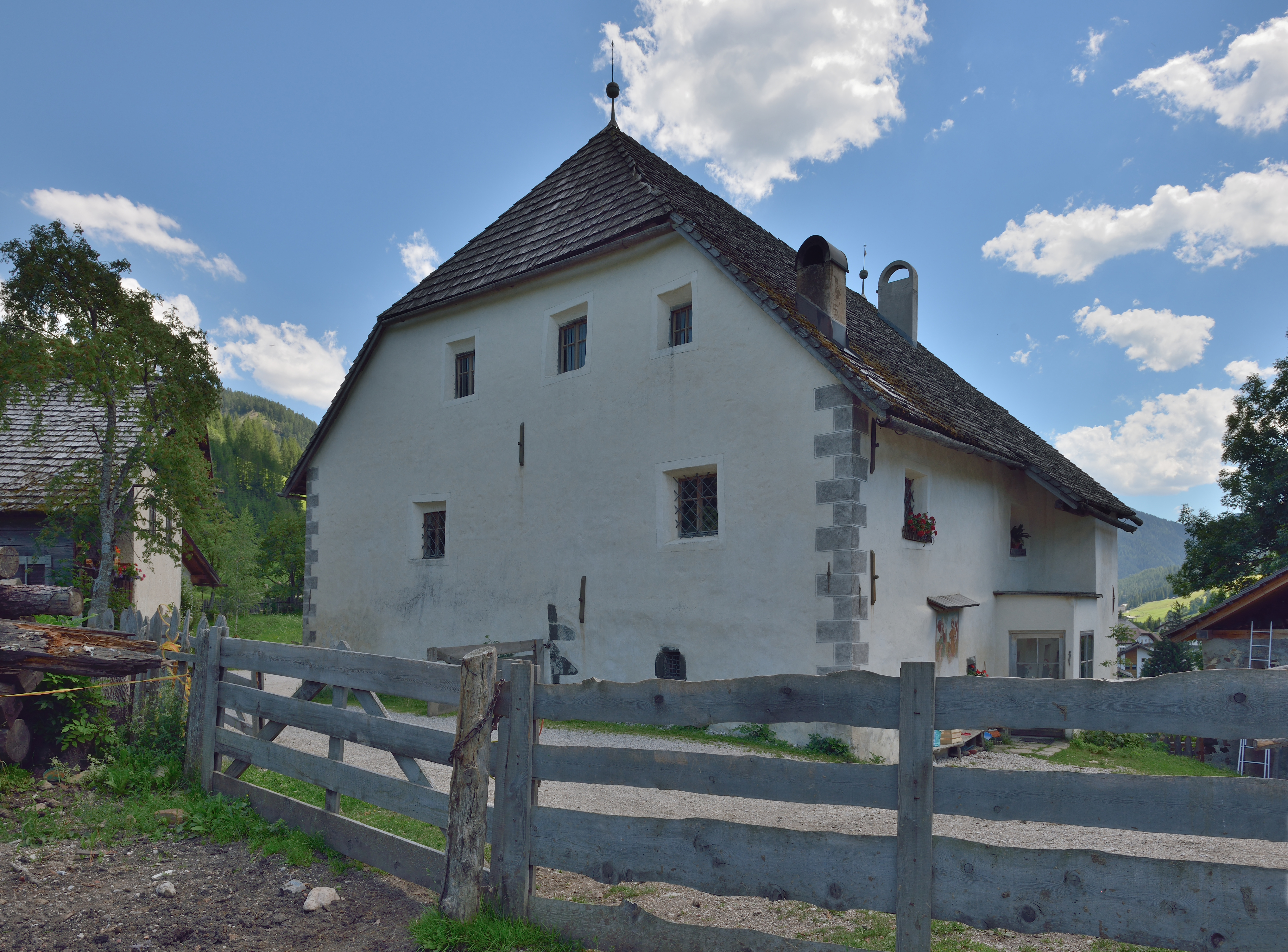
English: Manor "Colz" in San Linert
Deutsch: Der Ansitz "Colz" in Sankt Leonhard - Ehemals adeliger Ansitz. Krüppelwalmdach, tonnengewölbte Gänge mit Stichkappen und Putzgraten (Werkzeichen H. W. 1604), Spitzbogentüren. Fassadenfresko (St. Christoph, Florian), 17. Jh. Im Inneren Malereien an einer Bretterwand (Erschaffung Evas, Sündenfall) und in den Schildbögen (Kreuzigung, Eherne Schlange), 1612. |
||||||
Date | |||||||
Source | Own work | ||||||
Author |
|
Object location | 46° 36′ 50.8″ N, 11° 54′ 00.26″ E | View this and other nearby images on: OpenStreetMap | 46.614110; 11.900071 |
---|
Licensing
[edit]- You are free:
- to share – to copy, distribute and transmit the work
- to remix – to adapt the work
- Under the following conditions:
- attribution – You must give appropriate credit, provide a link to the license, and indicate if changes were made. You may do so in any reasonable manner, but not in any way that suggests the licensor endorses you or your use.
- share alike – If you remix, transform, or build upon the material, you must distribute your contributions under the same or compatible license as the original.
Permission is granted to copy, distribute and/or modify this document under the terms of the GNU Free Documentation License, Version 1.2 or any later version published by the Free Software Foundation; with no Invariant Sections, no Front-Cover Texts, and no Back-Cover Texts. A copy of the license is included in the section entitled GNU Free Documentation License.http://www.gnu.org/copyleft/fdl.htmlGFDLGNU Free Documentation Licensetruetrue |
}
This image was uploaded as part of Wiki Loves Monuments 2013.
Afrikaans ∙ Alemannisch ∙ العربية ∙ جازايرية ∙ azərbaycanca ∙ Bikol Central ∙ беларуская ∙ беларуская (тарашкевіца) ∙ български ∙ বাংলা ∙ brezhoneg ∙ bosanski ∙ català ∙ čeština ∙ Cymraeg ∙ dansk ∙ Deutsch ∙ Zazaki ∙ Ελληνικά ∙ English ∙ Esperanto ∙ español ∙ eesti ∙ euskara ∙ فارسی ∙ suomi ∙ français ∙ Frysk ∙ Gaeilge ∙ galego ∙ עברית ∙ हिन्दी ∙ hrvatski ∙ magyar ∙ հայերեն ∙ Bahasa Indonesia ∙ Ido ∙ italiano ∙ 日本語 ∙ ქართული ∙ 한국어 ∙ кыргызча ∙ Lëtzebuergesch ∙ latviešu ∙ Malagasy ∙ македонски ∙ മലയാളം ∙ Bahasa Melayu ∙ Malti ∙ norsk bokmål ∙ नेपाली ∙ Nederlands ∙ norsk nynorsk ∙ norsk ∙ polski ∙ português ∙ português do Brasil ∙ română ∙ русский ∙ sicilianu ∙ davvisámegiella ∙ slovenčina ∙ slovenščina ∙ shqip ∙ српски / srpski ∙ svenska ∙ ไทย ∙ Tagalog ∙ Türkçe ∙ українська ∙ اردو ∙ oʻzbekcha / ўзбекча ∙ Yorùbá ∙ 中文 ∙ 中文(中国大陆) ∙ 中文(简体) ∙ 中文(繁體) ∙ 中文(香港) ∙ 中文(臺灣) ∙ +/− |
{{ImageNote|id=1|x=3524|y=66
Annotations InfoField | This image is annotated: View the annotations at Commons |
dust spot
dust spot
This image has been assessed using the Quality image guidelines and is considered a Quality image.
العربية ∙ جازايرية ∙ беларуская ∙ беларуская (тарашкевіца) ∙ български ∙ বাংলা ∙ català ∙ čeština ∙ Cymraeg ∙ Deutsch ∙ Schweizer Hochdeutsch ∙ Zazaki ∙ Ελληνικά ∙ English ∙ Esperanto ∙ español ∙ eesti ∙ euskara ∙ فارسی ∙ suomi ∙ français ∙ galego ∙ עברית ∙ हिन्दी ∙ hrvatski ∙ magyar ∙ հայերեն ∙ Bahasa Indonesia ∙ italiano ∙ 日本語 ∙ Jawa ∙ ქართული ∙ 한국어 ∙ kurdî ∙ Lëtzebuergesch ∙ lietuvių ∙ македонски ∙ മലയാളം ∙ मराठी ∙ Bahasa Melayu ∙ Nederlands ∙ Norfuk / Pitkern ∙ polski ∙ português ∙ português do Brasil ∙ rumantsch ∙ română ∙ русский ∙ sicilianu ∙ slovenčina ∙ slovenščina ∙ shqip ∙ српски / srpski ∙ svenska ∙ தமிழ் ∙ తెలుగు ∙ ไทย ∙ Tagalog ∙ toki pona ∙ Türkçe ∙ українська ∙ vèneto ∙ Tiếng Việt ∙ 中文 ∙ 中文(简体) ∙ 中文(繁體) ∙ +/− |
File history
Click on a date/time to view the file as it appeared at that time.
Date/Time | Thumbnail | Dimensions | User | Comment | |
---|---|---|---|---|---|
current | 09:50, 9 October 2013 | 6,644 × 4,912 (16.09 MB) | Moroder (talk | contribs) | perspective 2 DSs | |
14:13, 1 September 2013 | 7,360 × 4,912 (18.21 MB) | Moroder (talk | contribs) | == {{int:filedesc}} == {{Information |Description={{Denkmalgeschütztes Objekt Südtirol|1=13583}} {{en|1=Manor "Sompunt" in Badia}} {{de|Der Ansitz "Sompunt" in Abtei - Ehemals adeliger Ansitz. Dre... |
You cannot overwrite this file.
File usage on Commons
The following 10 pages use this file:
- User:Dschwen/qic
- User:Mai-Sachme/South Tyrol/2013 September 1-10
- User talk:Moroder/Archives 2013-4
- User talk:Moroder/Archives 2013-4A
- Commons:Quality images/Subject/Places/Man made structures/Buildings, Exterior
- Commons:Quality images candidates/Archives October 11 2013
- Commons:Quality images candidates/Archives October 15 2013
- Commons:Quality images candidates/Archives September 18 2013
- File:Ciasa Sompunt dala strada.jpg (file redirect)
- File:Colz a San Linert dovia.jpg
File usage on other wikis
The following other wikis use this file:
- Usage on lld.wikipedia.org
Metadata
This file contains additional information such as Exif metadata which may have been added by the digital camera, scanner, or software program used to create or digitize it. If the file has been modified from its original state, some details such as the timestamp may not fully reflect those of the original file. The timestamp is only as accurate as the clock in the camera, and it may be completely wrong.
Camera manufacturer | NIKON CORPORATION |
---|---|
Camera model | NIKON D800 |
Author | Wolfgang Moroder |
Copyright holder |
|
Exposure time | 1/160 sec (0.00625) |
F-number | f/11 |
ISO speed rating | 100 |
Date and time of data generation | 13:09, 2 August 2013 |
Lens focal length | 24 mm |
User comments | Wolfgang Moroder lusenberg.com |
Orientation | Normal |
Horizontal resolution | 300 dpi |
Vertical resolution | 300 dpi |
Software used | Adobe Photoshop Elements 5.0 Windows |
File change date and time | 11:30, 9 October 2013 |
Y and C positioning | Centered |
Pair of black and white reference values |
|
Exposure Program | Aperture priority |
Exif version | 2.3 |
Date and time of digitizing | 13:09, 2 August 2013 |
Meaning of each component |
|
APEX exposure bias | −1 |
Maximum land aperture | 3 APEX (f/2.83) |
Metering mode | Pattern |
Light source | Unknown |
Flash | Flash did not fire, compulsory flash suppression |
DateTime subseconds | 30 |
DateTimeOriginal subseconds | 30 |
DateTimeDigitized subseconds | 30 |
Supported Flashpix version | 1 |
Color space | sRGB |
Sensing method | One-chip color area sensor |
File source | Digital still camera |
Scene type | A directly photographed image |
Custom image processing | Normal process |
Exposure mode | Auto exposure |
White balance | Auto white balance |
Digital zoom ratio | 1 |
Focal length in 35 mm film | 24 mm |
Scene capture type | Standard |
Scene control | None |
Contrast | Normal |
Saturation | Normal |
Sharpness | Normal |
Subject distance range | Unknown |
GPS tag version | 0.0.3.2 |
Supported Flashpix version | 1 |
Image width | 6,644 px |
Image height | 4,912 px |
Date metadata was last modified | 13:30, 9 October 2013 |
IIM version | 2 |
Structured data
Items portrayed in this file
depicts
2 August 2013
46°36'50.80"N, 11°54'0.25"E
image/jpeg
b2450c365057ae78c0f57f2895d2938dc405dd48
16,869,625 byte
4,912 pixel
6,644 pixel
- Cultural heritage monuments in South Tyrol with known IDs
- Photos by Moroder for Cultural heritage monuments in South Tyrol
- Files with coordinates missing SDC location of creation
- CC-BY-SA-3.0
- License migration redundant
- GFDL
- Self-published work
- Images from Wiki Loves Monuments 2013
- Images from Wiki Loves Monuments 2013 in South Tyrol
- Images from Wiki Loves Monuments missing SDC depicts
- Images from Wiki Loves Monuments missing SDC location of creation
- Images with annotations
- Quality images
- Quality images missing SDC depicts
- Quality images of South Tyrol
- Quality images by Moroder
- Quality images from Wiki Loves Monuments South Tyrol 2013