File:Colton’s Peru and Bolivia WDL11317.png
Jump to navigation
Jump to search

Size of this preview: 685 × 600 pixels. Other resolutions: 274 × 240 pixels | 549 × 480 pixels | 878 × 768 pixels | 1,170 × 1,024 pixels.
Original file (1,170 × 1,024 pixels, file size: 2.44 MB, MIME type: image/png)
Captions
Captions
Add a one-line explanation of what this file represents
Summary
[edit]
| Title |
Русский: Перу и Боливия на карте Колтона
Français : Le Pérou et la Bolivie de Colton
English: Colton’s Peru and Bolivia
中文:科尔顿的秘鲁和玻利维亚
Português: Peru e Bolívia de Colton
العربية: خريطة كولتون لبيرو وبوليفيا
Español: Perú y Bolivia, de Colton |
| Description |
Русский: На этой карте Перу и Боливии 1855 года показаны топографические особенности, большие и малые города, крепости, реки и речные пороги. Границы государств и регионов отмечены розовым, зеленым, желтым и синим цветами. На врезке в левом нижнем углу приведена карта столицы Перу Лимы. В верхнем правом углу карты показана река Мадейра, по которой проходит часть границы между Перу и Бразилией, и река Амазонка, верховья которой в Перу получили название Мараньон, а в Бразилии - Солимоэс. Карта сопровождается примечанием относительно судоходности реки Укаяли вплоть до места, называемого Вуэльта-дель-Диабло ("Дьявольская излучина"). Атакама, спорная территория, после Второй Тихоокеанской войны 1879-1883 гг. переданная Чили, показана в составе Боливии. Впервые данная карта была опубликована в 1855 году в "Атласе мира", выпущенном издательством Колтона. Компания "J.H. Colton & Company" была основана в Нью-Йорке вероятнее всего в 1831 году Джозефом Хатчинсом Колтоном (1800-1893 гг.), уроженцем штата Массачусетс. Колтон получил лишь начальное образование и не имел практически никакой профессиональной подготовки в области географии или картографии. Он превратил свою фирму в крупное издательство, выпускающее карты и атласы, скупая авторские права на различные карты и переиздавая их. В 50-х годах XIX века, после того как Колтон привлек к участию в бизнесе своих сыновей Джорджа Вулворта Колтона (1827-1901 гг.) и Чарлза Б. Колтона (1832-1916), издательство стало носить название "G.W. & C.B. Colton & Company". Практически все карты, изданные фирмой Колтона, включая данную, обрамлены изображениями переплетенных виноградных лоз, цветов или геометрических фигур.
Français : Cette carte du Pérou et de la Bolivie, datant de 1855, montre les caractéristiques topographiques, les villes, les villages, les forts, les rapides et les fleuves des deux pays. Les frontières nationales et régionales sont dessinées en rose, en vert, en jaune et en bleu. Un carton de Lima, capitale du Pérou, apparaît en bas à gauche. Le fleuve Madeira, qui forme la frontière entre le Pérou et Brésil, et l'Amazone, dont les sections supérieures sont appelées le Marañón, au Pérou, et le Solimões, au Brésil, sont tracés dans l'angle supérieur droit. Une note indique la navigabilité du fleuve Ucayali jusqu'à la Vuelta del Diablo (courbe du diable). L'Atacama, territoire contesté qui fut rattaché au Chili après la guerre du Pacifique de 1879–1883, fait partie de la Bolivie. La carte parut à l'origine dans Atlas du monde de Colton en 1855. L'entreprise J.H. Colton and Company fut fondée à New York, très probablement en 1831, par Joseph Hutchins Colton (1800–1893), Américain originaire du Massachusetts. Colton avait seulement reçu une éducation de base, et peu, voire aucune formation officielle en géographie ou en cartographie. Mais il parvint à faire de sa société une maison d'édition majeure de cartes et d'atlas en acquérant leurs droits d'auteur et en republiant d'autres cartes. Dans les années 1850, la société devint G.W. & C.B. Colton & Company, après que Colton s'associa avec ses fils, George Woolworth Colton (1827–1901) et Charles B. Colton (1832–1916). La quasi-totalité des cartes de Colton étaient encadrées de bordures décoratives de vignes, de fleurs ou de formes géométriques entrelacées, à l'instar de celle présentée ici.
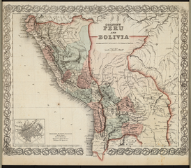
English: This 1855 map of Peru and Bolivia shows topographical features, cities, towns, forts, rapids, and rivers. National and regional boundaries are marked in pink, green, yellow, and blue. An inset map of Lima, the capital of Peru, appears in the lower-left-hand corner. In the upper right are the River Madeira, forming part of the border between Peru and Brazil, and the Amazon, the upper parts of which are known in Peru as the Marañón and in Brazil as the Solimões. A note indicates the navigability of the River Ucayali up to the Vuelta del Diablo (Devil’s Bend). Atacama, a disputed territory that was transferred to Chile after the 1879–83 War of the Pacific, is shown as part of Bolivia. The map originally appeared in Colton’s 1855 Atlas of the World. J.H. Colton & Company was founded in New York City, most likely in 1831, by Joseph Hutchins Colton (1800–93), a Massachusetts native who had only a basic education and little or no formal training in geography or cartography. Colton built the firm into a major publisher of maps and atlases by purchasing the copyrights to and republishing other maps. In the 1850s, the firm became G.W. & C.B. Colton & Company, after Colton brought his sons, George Woolworth Colton (1827–1901) and Charles B. Colton (1832–1916), into the business. As in this example, virtually all Colton maps were framed in decorative borders of intertwining vines, flowers, or geometric shapes.
中文:这幅 1855 年的秘鲁和玻利维亚地图展现了两个国家的地貌、城市、城镇、堡垒、急流和河流。国家和地区边界分别采用粉线、绿线、黄线和蓝线标注。左下角是秘鲁首都利马的插页地图,右上方是马德拉河和亚马逊河:马德拉河形成了秘鲁和巴西之间的部分边界,而亚马逊河上游部分在秘鲁被称为马拉尼翁河,在巴西则被称为索利蒙伊斯河。图中一则注解指出了乌卡亚利河到魔鬼弯 (Vuelta del Diablo) 的适航性。阿塔卡玛是一片有争议的领土,1879-83 年太平洋战争后受智利控制,在此地图中显示为玻利维亚领土。该地图最早出现在科尔顿 1855 年的《世界地图集》中。J.H. 科尔顿公司 (J.H. Colton & Company) 成立于纽约市,时间很可能是在 1831 年,创始人是约瑟夫·赫钦斯·科尔顿(Joseph Hutchins Colton,1800–93 年),他是马萨诸塞州本地人,只接受过基本的教育,几乎没有受过任何有关地理或制图方面的正式培训。科尔顿通过购买其他地图的版权并进行再版,将公司发展成了一家主要的地图和地图集出版商。19 世纪 50 年代,科尔顿将其子乔治·伍尔沃斯·科尔顿(George Woolworth Colton,1827–1901 年)和查尔斯·B·科尔顿(Charles B. Colton,1832–1916 年)带入企业中后,公司更名为 G.W. 及 C.B. 科尔顿公司 (G.W. & C.B. Colton & Company)。正如该幅地图所示,几乎所有的科尔顿地图都配有由相互交织的藤蔓、花卉或几何图案组成的装饰花边。
Português: Este mapa de 1855 do Peru e da Bolívia mostra características topográficas, cidades, vilarejos, fortes, corredeiras e rios. As fronteiras nacionais e regionais estão marcadas em rosa, verde, amarelo e azul. Um mapa inserido de Lima, a capital do Peru, aparece no canto inferior esquerdo. No canto superior direito está o Rio Madeira, formando parte da fronteira do Peru e Brasil, e o Rio Amazonas, cuja parte superior é conhecida no Peru como Marañón e, no Brasil, como Solimões. Uma nota indica a navegabilidade do Rio Ucayali até a Vuelta del Diablo (Curva do Diabo). O Atacama, território disputado transferido ao Chile após a Guerra do Pacífico de 1879 a 1883, é exibido como parte da Bolívia. O mapa surgiu originalmente no Atlas do Mundo de Colton, em 1855. A J.H. Colton & Cia. foi fundada na cidade de Nova York, provavelmente em 1831, por Joseph Hutchins Colton (1800-1893), natural de Massachusetts, que tinha apenas o ensino fundamental e pouco ou nenhum treinamento formal em geografia e cartografia. Colton transformou a empresa em uma grande editora de mapas e atlas, adquirindo os direitos autorais de outros mapas e lançando novas edições destes. Em 1850, a empresa se tornou G.W. & C.B. Colton & Company, após Colton trazer seus filhos George Woolworth Colton (1827-1901) e Charles B. Colton (1832-1916) para o negócio. Como visto neste exemplo, praticamente todos os mapas de Colton eram emoldurados por bordas decorativas de videiras entrelaçadas, flores ou formas geométricas.
العربية: تُظهِر خريطة بيرو وبوليفيا هذه، التي ترجع إلى العام 1855، الخصائص الطُبوغرافية والمدن والبلدات والحصون والشلالات والأنهار. وتتخذ الحدود الوطنية والإقليمية اللون الوردي والأخضر والأصفر والأزرق. وهناك خريطة مُلحقة لِليما، عاصمة بيرو، في الركن الأيسر السفلي. وفي الجزء الأيمن العلوي يوجد نهر ماديرا، الذي يُشَكّل جزءًا من الحدود الفاصلة بين بيرو والبرازيل، ونهر الأمازون، الذي تُعرَف الأجزاء العلوية منه بمارانيون في بيرو وسوليميوس في البرازيل. توضح إحدى الملاحظات أن نهر أوكايالي يمكن الإبحار فيه وصولًا إلى فويلتا ديل ديابلو (منحنى الشيطان). وتظهر أتاكاما، وهي منطقة متنازع عليها انتقلت ملكيتها إلى شيلي بعد حرب المحيط الهادئ التي نشبت في الفترة ما بين 1879 و1883، جزءًا من بوليفيا. ظهرت الخريطة في الأصل في أطلس العالم لكولتون الذي يرجع إلى العام 1855. أَسَّس جوزيف هاتشينز كولتون (1800–1893)، الذي وُلِد في ماساتشوسيتس وتلقى تعليمًا أساسيًا فقط وربما القليل من التدريب الرسمي في الجغرافيا ورسم الخرائط، مؤسسة ج. هـ. كولتون وشركاه في نيويورك سيتي عام 1831 على الأرجح. طوَّر كولتون الشركة حتى صارت واحدة من أكبر دور نشر الخرائط والأطالس، وذلك من خلال شراء حقوق طبع الخرائط الأخرى وإعادة نشرها. وفي خمسينيات القرن التاسع عشر، تغيّر اسم المؤسسة إلى ج. و. وَت. ب. كولتون وشركاهما، بعدما أَشْرَك كولتون أبنائه، جورج وُلْوارث كولتون (1827–1901) وتشارلز ب. كولتون (1832–1916)، في العمل. وكما هو موضح في هذا المثال، أُحيطت جميع خرائط كولتون تقريبًا بأُطُر مزخرفة من فروع الكَرمة المتشابكة أو الأزهار أو الأشكال الهندسية.
Español: En este mapa de 1855 del Perú y de Bolivia se muestran las características topográficas, las ciudades, los pueblos, los fuertes, los rápidos y los ríos. Las fronteras nacionales y regionales están marcadas en los colores rosa, verde, amarillo y azul. En la esquina inferior izquierda, hay un recuadro con un mapa de Lima, la capital del Perú. En la parte superior derecha están el río Madeira, que forma parte de la frontera entre el Perú y Brasil, y el Amazonas, cuyos tramos superiores se conocen, en el Perú, como el Marañón y, en Brasil, como el Solimões. Una nota indica la navegabilidad del río Ucayali hasta la Vuelta del Diablo. Atacama, un territorio en disputa que fue transferido a Chile después de la Guerra del Pacífico de 1879-1883, se muestra como parte de Bolivia. Originalmente, el mapa apareció en el libro de Colton de 1855, Altas mundial. J. H. Colton & Company fue fundada en la ciudad de Nueva York, muy probablemente en 1831, por Joseph Hutchins Colton (1800-1893), un nativo de Massachusetts que solo contaba con educación básica y poca o ninguna capacitación formal en geografía o cartografía. Colton convirtió la empresa en una importante editora de mapas y atlas al comprar los derechos de autor de otros mapas y volver a publicarlos. En la década de 1850, la empresa se convirtió en G. W. & C. B. Colton & Company, después de que Colton agregara al negocio a sus hijos, George Woolworth Colton (1827-1901) y Charles B. Colton (1832-1916). Como en este ejemplo, casi todos los mapas de Colton estaban enmarcados con bordes decorativos de vides, flores o formas geométricas entrelazadas. |
| Date | 1855 |
| Medium |
Русский: Карты
Français : Cartes
English: Maps
中文:地图
Português: Mapas
العربية: خرائط
Español: Mapas |
| Dimensions |
English: 2 maps on 1 sheet : facsimile, color ; 33 x 40 centimeters |
| Collection |
Русский: Мемориальная библиотека имени Колумба, Организация Американских Государств
Français : Bibliothèque Colomb, Organisation des États Américains
English: Columbus Memorial Library, Organization of American States
中文:美洲国家组织哥伦布纪念图书馆
Português: Biblioteca do Memorial de Colombo, Organização dos Estados Americanos
العربية: مكتبة كولومبوس التذكارية، منظمة الدول الأمريكية
Español: Biblioteca Colón de la Organización de los Estados Americanos |
| Place of creation |
Русский: Боливия
Français : Bolivie
English: Bolivia
中文:玻利维亚
Português: Bolívia
العربية: بوليفيا
Español: Bolivia |
| Notes |
Русский: Масштаб: примерно 1 дюйм к 7 900 000 футов
Français : Échelle : 1 pouce = 7 900 000 pieds env.
English: Scale around 1:7,900,000
中文:比例尺约为 1 英寸代表 7,900,000 英尺
Português: Escala por volta de 1 polegada para 7.900.000 pés
العربية: مقياس الرسم حوالي 1 بوصة إلى 7,900,000 قدم
Español: Escala: alrededor de 1 pulgada por 7 900 000 pies |
| Source/Photographer |
|
Licensing
[edit]
|
This is a faithful photographic reproduction of a two-dimensional, public domain work of art. The work of art itself is in the public domain for the following reason:
The official position taken by the Wikimedia Foundation is that "faithful reproductions of two-dimensional public domain works of art are public domain".
This photographic reproduction is therefore also considered to be in the public domain in the United States. In other jurisdictions, re-use of this content may be restricted; see Reuse of PD-Art photographs for details. | ||||
File history
Click on a date/time to view the file as it appeared at that time.
| Date/Time | Thumbnail | Dimensions | User | Comment | |
|---|---|---|---|---|---|
| current | 19:24, 10 March 2014 | | 1,170 × 1,024 (2.44 MB) | Fæ (talk | contribs) | =={{int:filedesc}}== {{Artwork |artist = |author = |title ={{ru|1=Перу и Боливия на карте Колтона}} {{fr|1=Le Pérou et la Bolivie de Colton}} {{en|1=Colton’s Peru and Bolivia}} {{zh|1=科尔顿的秘鲁和玻利维亚}} {{p... |
You cannot overwrite this file.
File usage on Commons
The following page uses this file: