File:Colton's Virginia. LOC lva0000093.jpg
Jump to navigation
Jump to search

Size of this preview: 711 × 599 pixels. Other resolutions: 285 × 240 pixels | 570 × 480 pixels | 911 × 768 pixels | 1,215 × 1,024 pixels | 2,430 × 2,048 pixels | 5,116 × 4,312 pixels.
Original file (5,116 × 4,312 pixels, file size: 5.45 MB, MIME type: image/jpeg)
Captions
Captions
Add a one-line explanation of what this file represents
Summary
[edit]| Description |
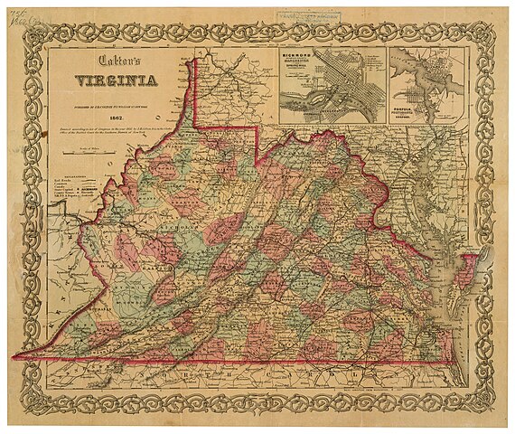
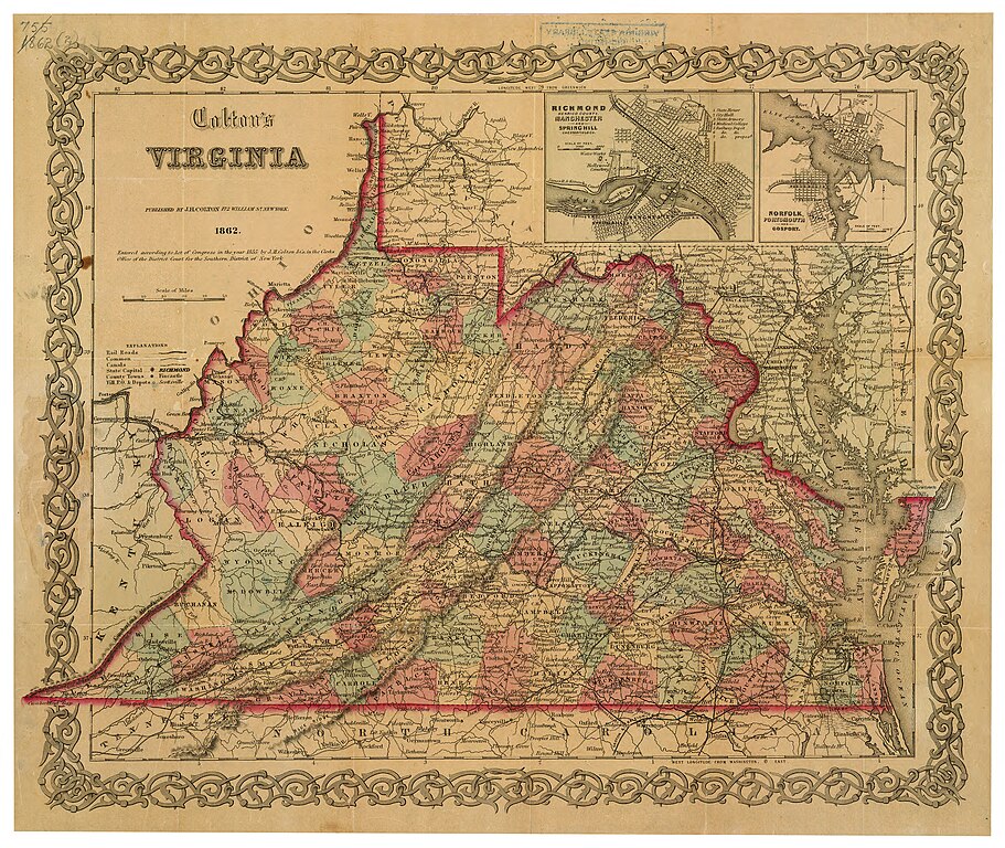
English: "Entered according to Act of Congress in the year 1855 by J.H. Colton & Co. in the Clerks Office of the District Court for the Southern District of New York." Accompanied by cover: Colton's map of Virginia / J.H. Colton. Insets: Richmond, Henrico County, Manchester and Spring Hill, Chesterfield Co. -- Norfolk, Portsmouth and Gosport. Relief shown by hachures. Shows roads, railroads, canals, and post offices. This item is in the Map Collection of the Library of Virginia; please contact the Library's Archives Research Services department for more information. Available also through the Library of Congress web site as raster image. c.1, Feb. 1926, N.F. Morrison, b; c. 2 1954 photocopy, LVA; Feb. 2003, Map Cataloging Team. C. 1, map accession no. 1932 (1926); c. 2 (negative photostat, LVA, Dec. 1954, approx. 45 x 52 cm.) Civil War project no.: lva00093. Conservation: copy 1 Etherington Conservation Center, Dec. 2002. Digital image available: 13 3/4 x 16 1/2 in. Previously filed as: 755 1862 (2). |
||
| Title | Colton's Virginia. | ||
| Shelf ID | https://www.loc.gov/item/lva0000093/ | ||
| Date | |||
| Source | https://www.loc.gov/item/lva0000093/ | ||
| Author | Colton, J. H. (Joseph Hutchins) | ||
| Permission (Reusing this file) |
|
||
| Other versions |
|
||
| Location | United States · Virginia · West Virginia | ||
| Part of | Military Battles And Campaigns · American Memory · Civil War Maps · Geography And Map Division | ||
| Subject | Virginia · Civil War · United States · Maps · West Virginia · History |


Licensing
[edit]
|
This is a faithful photographic reproduction of a two-dimensional, public domain work of art. The work of art itself is in the public domain for the following reason:
The official position taken by the Wikimedia Foundation is that "faithful reproductions of two-dimensional public domain works of art are public domain".
This photographic reproduction is therefore also considered to be in the public domain in the United States. In other jurisdictions, re-use of this content may be restricted; see Reuse of PD-Art photographs for details. | ||||
File history
Click on a date/time to view the file as it appeared at that time.
| Date/Time | Thumbnail | Dimensions | User | Comment | |
|---|---|---|---|---|---|
| current | 05:47, 16 May 2018 | | 5,116 × 4,312 (5.45 MB) | Fæ (talk | contribs) | LOC Maps https://www.loc.gov/item/lva0000093/ #881 |
You cannot overwrite this file.
File usage on Commons
The following page uses this file: