File:Colorado Coalfield War map.svg
Jump to navigation
Jump to search

Size of this PNG preview of this SVG file: 449 × 600 pixels. Other resolutions: 180 × 240 pixels | 359 × 480 pixels | 575 × 768 pixels | 767 × 1,024 pixels | 1,533 × 2,048 pixels | 456 × 609 pixels.
Original file (SVG file, nominally 456 × 609 pixels, file size: 628 KB)
Captions
Captions
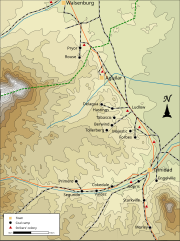
Map illustrating the main locations of striking miners' colonies and towns during the Colorado Coalfield War, 1913-14
Summary
[edit]
| Description |
English: Key locations of the Colorado Coalfield War, 1913-14, based on Map of Colorado, C S Hammond & Co. NY, 1911 and Walker, Mark (2003). "The Ludlow Massacre: Class, Warfare, and Historical Memory in Southern Colorado". Historical Archaeology. 37 (3): 67. ISSN 0440-9213 |
| Date | |
| Source | Own work |
| Author | Goldsztajn |
Licensing
[edit]
I, the copyright holder of this work, hereby publish it under the following license:
This file is licensed under the Creative Commons Attribution-Share Alike 4.0 International license.
- You are free:
- to share – to copy, distribute and transmit the work
- to remix – to adapt the work
- Under the following conditions:
- attribution – You must give appropriate credit, provide a link to the license, and indicate if changes were made. You may do so in any reasonable manner, but not in any way that suggests the licensor endorses you or your use.
- share alike – If you remix, transform, or build upon the material, you must distribute your contributions under the same or compatible license as the original.
File history
Click on a date/time to view the file as it appeared at that time.
| Date/Time | Thumbnail | Dimensions | User | Comment | |
|---|---|---|---|---|---|
| current | 13:13, 14 September 2021 | | 456 × 609 (628 KB) | Goldsztajn (talk | contribs) | Uploaded own work with UploadWizard |
You cannot overwrite this file.
File usage on Commons
There are no pages that use this file.
File usage on other wikis
The following other wikis use this file:
- Usage on avk.wikipedia.org
- Usage on en.wikipedia.org