File:Colonizationoftheamericas-blank.png
Jump to navigation
Jump to search
Size of this preview: 463 × 599 pixels. Other resolutions: 185 × 240 pixels | 470 × 608 pixels.
Original file (470 × 608 pixels, file size: 9 KB, MIME type: image/png)
Captions
Captions
Add a one-line explanation of what this file represents
Summary
[edit]
| Description |
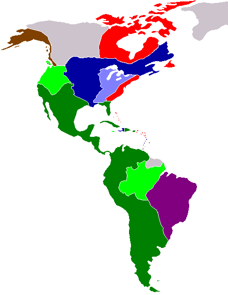
English: Blank map of European colonization of the Americas in 1750.
Spanish territory
Spanish claimed territory
Portuguese territory
French territory
French territory claimed by Britain
British territory
Russian territory Esperanto: Politika mapo de Ameriko en 1750.
Hispanaj teritorioj
Teritorioj postulitaj de Hispanio
Portugalaj teritorio
Francaj teritorioj
Britiaj teritorioj
Franca teritorioj postulitaj de Britio
Rusaj teritorioj Français : Carte muette de la colonisation des Amériques par les nations européennes en 1750.
Territoire espagnol
Territoire revendiqué par l'Espagne
Territoire portugais
Territoire français
Territoire français revendiqué par les Britanniques
Territoire britannique
Territoire Russe Italiano: La carta politica delle Americhe nel 1750.
Territori spagnoli
Territori reclamati dagli spagnoli
Territori portoghesi
Territori francesi
Territori britannici
Territori francesi reclamati dai britannici
Territori russi Português: Mapa político da América em 1750.
Territórios espanhóis
Territórios reivindicados pela Espanha
Territórios portugueses
Territórios franceses
Territórios britânicos
Territórios franceses reivindicados pelos britânicos
Territórios russos |
| Date |
2007-07-25 Original upload date : 2006-11-05 |
| Source | Based upon en:Image:Spanish colonization of the Americas.png by Satesclop. Originally from en.wikipedia; description page is/was here. |
| Author |
Sémhur (talk) Original uploader was 24630 at en.wikipedia |
| Other versions | English version : Image:Colonizationoftheamericas.png |

|
This historical map image could be re-created using vector graphics as an SVG file. This has several advantages; see Commons:Media for cleanup for more information. If an SVG form of this image is available, please upload it and afterwards replace this template with
{{vector version available|new image name}}.
It is recommended to name the SVG file “Colonizationoftheamericas-blank.svg”—then the template Vector version available (or Vva) does not need the new image name parameter. |
| Camera location | | View this and other nearby images on: OpenStreetMap |
|---|
Licensing
[edit]
| This work has been released into the public domain by its author, I, Sémhur. This applies worldwide. In some countries this may not be legally possible; if so: I, Sémhur grants anyone the right to use this work for any purpose, without any conditions, unless such conditions are required by law. |
File history
Click on a date/time to view the file as it appeared at that time.
| Date/Time | Thumbnail | Dimensions | User | Comment | |
|---|---|---|---|---|---|
| current | 14:30, 25 July 2007 | | 470 × 608 (9 KB) | Sémhur (talk | contribs) | {{Information |Description= {{en|Blank map of European colonization of the Americas in 1750.}} {{fr|Carte muette de la colonisation des Amériques par les nations européennes en 1750.}} {{en|Key:}} {{legend|#008000|Spanish territory}} {{legend|#00FF00|S |
You cannot overwrite this file.
File usage on Commons
There are no pages that use this file.
File usage on other wikis
The following other wikis use this file:
- Usage on cs.wikipedia.org
- Usage on fr.wikipedia.org
- Usage on fur.wikipedia.org
- Usage on gcr.wikipedia.org
- Usage on he.wikipedia.org
- Usage on it.wikipedia.org
- Usage on mwl.wikipedia.org
- Usage on pt.wikipedia.org
- Colonização espanhola da América
- Cronologia da colonização da América
- História da descolonização da América
- Colonização europeia da América
- Colonização portuguesa da América
- Predefinição:Colonização europeia da América
- Colonização francesa da América
- Descobrimento da América
- Colonização britânica da América
- Colonização viquingue da América
- Colonização alemã da América
- Colonização curlandesa da América
- Colonização neerlandesa da América
- Colonização russa da América
- Colonização dinamarquesa da América
- Colonização hospitalária da América
- Primeira onda da colonização europeia
- Colonização sueca da América
- Colonização escocesa da América
- Usage on sk.wikipedia.org