File:Collection of maps relating to publication of "New Hampshire, a guide to the Granite State" by Federal Writers' Project of the Works Progress Administration for the State of New Hampshire LOC 2008624019-13.jpg
Jump to navigation
Jump to search

Size of this preview: 800 × 595 pixels. Other resolutions: 320 × 238 pixels | 640 × 476 pixels | 1,024 × 761 pixels | 1,280 × 951 pixels | 2,560 × 1,903 pixels | 6,042 × 4,491 pixels.
Original file (6,042 × 4,491 pixels, file size: 1.9 MB, MIME type: image/jpeg)
Captions
Captions
Add a one-line explanation of what this file represents
Summary
[edit]| Description |
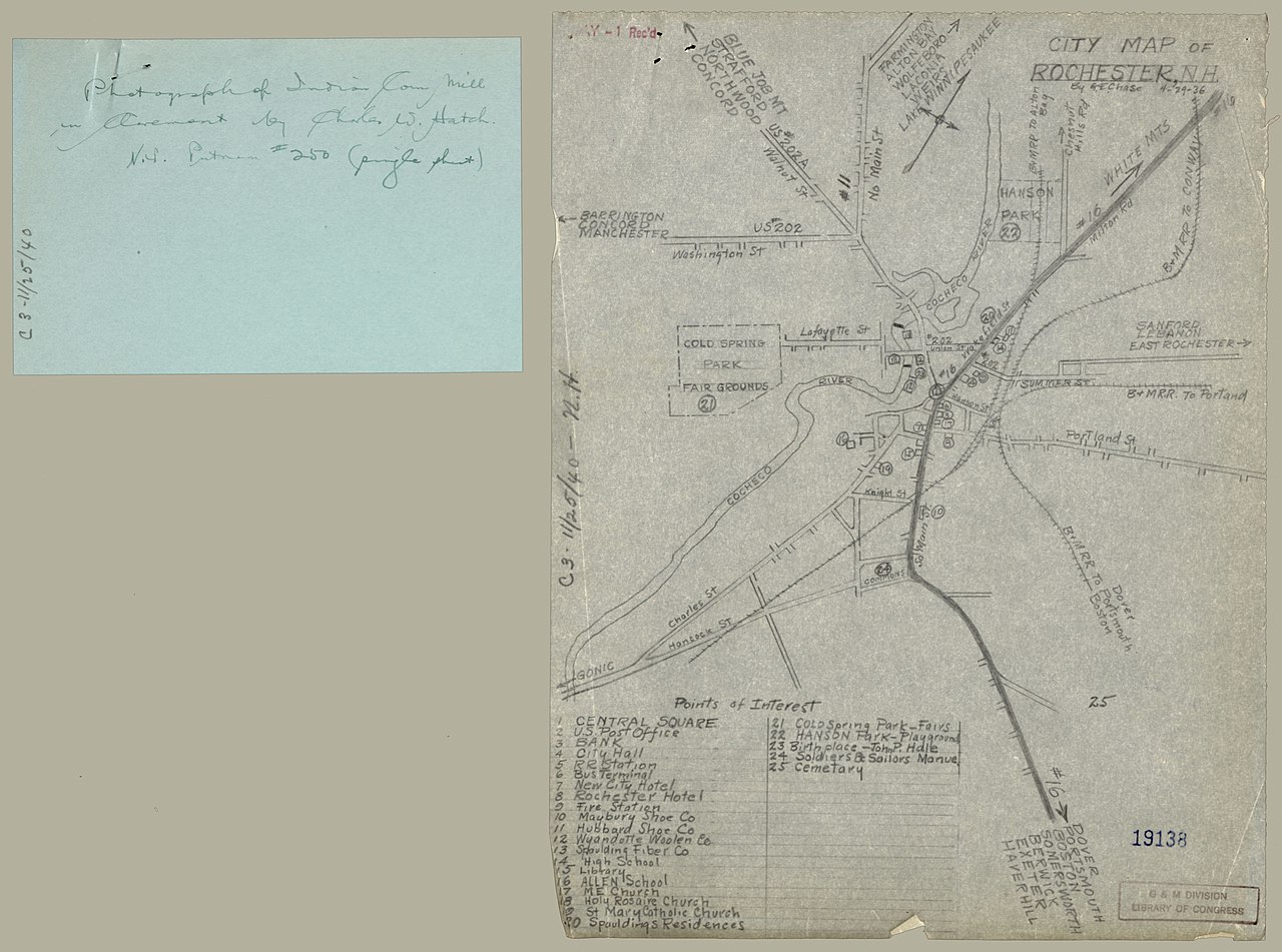
English: Consists of state maps showing tour routes, administrative divisions, geology, and forest reserves; maps of cities of Dover, Portsmouth, and Rochester; map of village of Durham; and map of Connecticut River watershed in New Hampshire that "shows progress of the crest of the flood, Nov. 3-6, 1927." Accompanied by 2 sheets of text and sheet with geological graphs. Some maps indexed. Some sheets annotated in pencil along edge or on verso: C. 3--11/25/40--N.H. Available also through the Library of Congress Web site as a raster image. Acquisitions control no.: 1999-117 |
||
| Title | [Collection of maps relating to publication of "New Hampshire, a guide to the Granite State" by Federal Writers' Project of the Works Progress Administration for the State of New Hampshire]. | ||
| Shelf ID | G3741.E635 coll .C6 | ||
| Parent | https://www.loc.gov/resource/g3741em.gct00123/ | ||
| Sheet title | City map of Rochester, N.H. | ||
| Date | |||
| Source | https://www.loc.gov/item/2008624019/ | ||
| Author | Federal Writers' Project Of The Works Progress Administration For The State Of New Hampshire | ||
| Permission (Reusing this file) |
|
||
| Other versions |
|
||
| Location | Portsmouth · Rochester · Connecticut River Watershed · United States · Durham · New Hampshire · Dover | ||
| Part of | American Memory · General Maps · Catalog · Geography And Map Division | ||
| Subject | Forest Reserves · Portsmouth · Rochester · Geology · Rochester (N.H.) · Floods · Connecticut River Watershed · United States · Maps · Durham · Tours · Dover (N.H.) · Administrative And Political Divisions · New Hampshire · Dover · Durham (N.H.) · Manuscript Maps · Portsmouth (N.H.) |


Licensing
[edit]
This work is in the public domain in the United States because it is a work prepared by an officer or employee of the United States Government as part of that person’s official duties under the terms of Title 17, Chapter 1, Section 105 of the US Code.
Note: This only applies to original works of the Federal Government and not to the work of any individual U.S. state, territory, commonwealth, county, municipality, or any other subdivision. This template also does not apply to postage stamp designs published by the United States Postal Service since 1978. (See § 313.6(C)(1) of Compendium of U.S. Copyright Office Practices). It also does not apply to certain US coins; see The US Mint Terms of Use.
|
 | |
| This file has been identified as being free of known restrictions under copyright law, including all related and neighboring rights. | ||
File history
Click on a date/time to view the file as it appeared at that time.
| Date/Time | Thumbnail | Dimensions | User | Comment | |
|---|---|---|---|---|---|
| current | 18:40, 23 August 2018 | | 6,042 × 4,491 (1.9 MB) | Fæ (talk | contribs) | LOC Maps multisheet https://www.loc.gov/item/2008624019/ sheet 13 of 15 #15491 |
You cannot overwrite this file.
File usage on Commons
The following page uses this file: