File:Colias meadii P1230950a.jpg
From Wikimedia Commons, the free media repository
Jump to navigation
Jump to search
Size of this preview: 706 × 599 pixels. Other resolutions: 283 × 240 pixels | 566 × 480 pixels | 905 × 768 pixels | 1,206 × 1,024 pixels | 2,413 × 2,048 pixels | 2,581 × 2,191 pixels.
Original file (2,581 × 2,191 pixels, file size: 1.35 MB, MIME type: image/jpeg)
File information
Structured data
Captions
Summary
[edit]Author | |
Description |
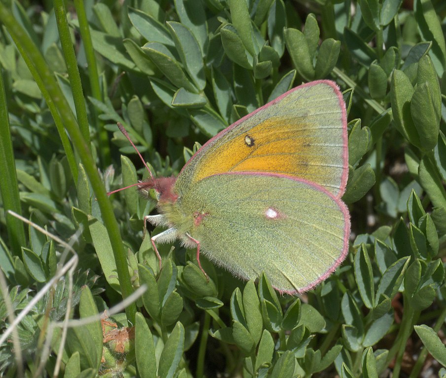
Colias meadii, Mead's sulphur, ID Confidence: 87 |
Depicted place | Pitkin County, CO, 39°6.366'N 106°59.684'W, Elevation: 12537 |
Date | 4 August 2011 |
Credit line | Robert Webster / xpda.com / CC-BY-SA-4.0 |
References | Pictures from Earth, Colias meadii |
Source | Own work |
Licensing
[edit]I, the copyright holder of this work, hereby publish it under the following license:
This file is licensed under the Creative Commons Attribution-Share Alike 4.0 International license.
- You are free:
- to share – to copy, distribute and transmit the work
- to remix – to adapt the work
- Under the following conditions:
- attribution – You must give appropriate credit, provide a link to the license, and indicate if changes were made. You may do so in any reasonable manner, but not in any way that suggests the licensor endorses you or your use.
- share alike – If you remix, transform, or build upon the material, you must distribute your contributions under the same or compatible license as the original.
File history
Click on a date/time to view the file as it appeared at that time.
Date/Time | Thumbnail | Dimensions | User | Comment | |
---|---|---|---|---|---|
current | 01:29, 27 March 2018 | 2,581 × 2,191 (1.35 MB) | Xpda (talk | contribs) |
You cannot overwrite this file.
File usage on Commons
The following 2 pages use this file:
File usage on other wikis
The following other wikis use this file:
- Usage on en.wikipedia.org
- Usage on fr.wikipedia.org
- Usage on nl.wikipedia.org
- Usage on pt.wikipedia.org
- Usage on ru.wikipedia.org
- Usage on www.wikidata.org
Metadata
This file contains additional information such as Exif metadata which may have been added by the digital camera, scanner, or software program used to create or digitize it. If the file has been modified from its original state, some details such as the timestamp may not fully reflect those of the original file. The timestamp is only as accurate as the clock in the camera, and it may be completely wrong.
Image title | Mead's Sulphur (Colias meadii) |
---|---|
Camera manufacturer | Panasonic |
Camera model | DMC-GF1 |
Exposure time | 1/100 sec (0.01) |
F-number | f/14 |
ISO speed rating | 100 |
Date and time of data generation | 17:39, 4 August 2011 |
Lens focal length | 45 mm |
Latitude | 39° 6′ 21.96″ N |
Longitude | 106° 59′ 41.04″ W |
Altitude | 3,821.464 meters above sea level |
Orientation | Normal |
Horizontal resolution | 300 dpi |
Vertical resolution | 300 dpi |
Software used | Photo Mud 4 |
File change date and time | 17:39, 4 August 2011 |
Y and C positioning | Co-sited |
Pair of black and white reference values |
|
Exposure Program | Aperture priority |
Exif version | 2.21 |
Date and time of digitizing | 17:39, 4 August 2011 |
Meaning of each component |
|
APEX exposure bias | 0 |
Maximum land aperture | 3 APEX (f/2.83) |
Metering mode | Center weighted average |
Light source | Unknown |
Flash | Flash did not fire, compulsory flash suppression |
Supported Flashpix version | 1 |
Color space | sRGB |
Sensing method | One-chip color area sensor |
File source | Digital still camera |
Scene type | A directly photographed image |
Custom image processing | Normal process |
Exposure mode | Auto exposure |
White balance | Auto white balance |
Digital zoom ratio | 0 |
Focal length in 35 mm film | 90 mm |
Scene capture type | Standard |
Scene control | None |
Contrast | Soft |
Saturation | Low saturation |
Sharpness | Normal |
GPS time (atomic clock) | 17:39 |
Speed unit | Miles per hour |
Speed of GPS receiver | 0 |
Reference for direction of movement | True direction |
Direction of movement | 0 |
Geodetic survey data used | WGS-84 |
GPS date | 4 August 2011 |
GPS tag version | 0.0.2.2 |
Structured data
Items portrayed in this file
depicts
4 August 2011
image/jpeg
318fc3614d93baabef3c222d950995650d879c39
1,413,571 byte
2,191 pixel
2,581 pixel
Hidden categories: