File:Coldspring Head Lighthouse.jpg

Original file (4,288 × 2,848 pixels, file size: 10.65 MB, MIME type: image/jpeg)
Captions
Captions
Summary
[edit]| Description |
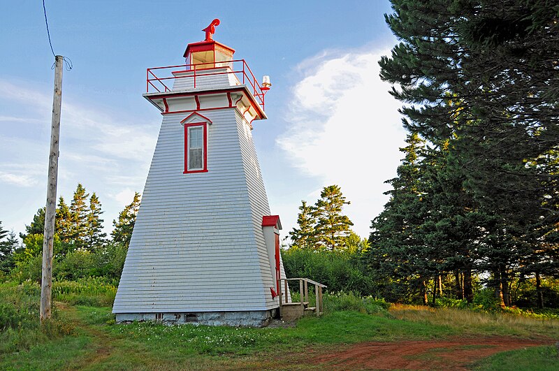
English: Coldspring Head Lighthouse.
The tower was built at a cost of $894 under contract to J. Harvey Brownell, who also began serving as the first keeper of the light on April 12, 1890. After just thirteen months at the post, Harvey resigned, and was replaced by his relative Alfred Brownell. At the time the Coldspring Head Lighthouse was under construction work was well underway on the Chignecto Ship Railway, which was designed to haul ships on a railroad between Fort Lawrence on the Bay of Fundy and Tidnish on the Northumberland Strait. This seventeen-mile-long shortcut was designed to reduce the journey between the St. Lawrence and New England by several hundred miles, as vessels would not need to sail around the Atlantic Ocean side of Nova Scotia. Work on the railroad began in October of 1888, but was never completed due to the 1890 collapse of Baring Brothers and Company, the London bank backing the project. When work halted, three-quarters of the project was complete, including the docks at Fort Lawrence and Tidnish, and thirteen of the seventeen miles of track. The failure to finish the project certainly diminished the amount of marine traffic that would otherwise have used Baie Verte. Location: 100 feet from shore, north side of head Standing: This light is still standing. Operating: This light is operational Automated: All operating lights in Nova Scotia are automated. Date Automated: Automated by 1980 Began: 1890 Year Lit: 1890 Structure Type: Tapered Square wood tower, white, red lantern Light Characteristic: Flashing White (1992) Tower Height: 036ft feet high. Light Height: 060ft feet above water level. Information from: www.nslps.com/index.aspx www.lighthousefriends.com/pull-lights.asp.webloc |
||||||||||||||
| Date | Taken on 6 August 2011, 07:01 | ||||||||||||||
| Source |
DGJ_3964 - Coldspring Head Lighthouse
|
||||||||||||||
| Author |
|
||||||||||||||
.jpg)
| Camera location | | View this and other nearby images on: OpenStreetMap |
|---|
Licensing
[edit]
- You are free:
- to share – to copy, distribute and transmit the work
- to remix – to adapt the work
- Under the following conditions:
- attribution – You must give appropriate credit, provide a link to the license, and indicate if changes were made. You may do so in any reasonable manner, but not in any way that suggests the licensor endorses you or your use.
- share alike – If you remix, transform, or build upon the material, you must distribute your contributions under the same or compatible license as the original.
| This image, originally posted to Flickr, was reviewed on March 9, 2012 by the administrator or reviewer File Upload Bot (Magnus Manske), who confirmed that it was available on Flickr under the stated license on that date. |
File history
Click on a date/time to view the file as it appeared at that time.
| Date/Time | Thumbnail | Dimensions | User | Comment | |
|---|---|---|---|---|---|
| current | 01:01, 9 March 2012 | | 4,288 × 2,848 (10.65 MB) | File Upload Bot (Magnus Manske) (talk | contribs) | {{Information |Description=PLEASE, no multi invitations, glitters or self promotion in your comments. My photos are FREE for anyone to use, just give me credit and it would be nice if you let me know, thanks - NONE OF MY PICTURES ARE HDR. The tower w... |
You cannot overwrite this file.
File usage on Commons
The following 2 pages use this file:
.jpg&redirect=no)