File:Col de la Bonnette South.jpg
Jump to navigation
Jump to search

Size of this preview: 799 × 198 pixels. Other resolutions: 320 × 79 pixels | 640 × 159 pixels | 1,024 × 254 pixels | 1,280 × 317 pixels | 7,252 × 1,798 pixels.
Original file (7,252 × 1,798 pixels, file size: 10.93 MB, MIME type: image/jpeg)
Captions
Captions
Add a one-line explanation of what this file represents
Summary
[edit]
| Description |
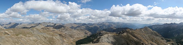
English: View from Cime de la Bonnette southwards into the Tinée valley |
| Date | 10.09.2009 |
| Source | Own work |
| Author | Ingo Mehling |
| Camera location | | View this and other nearby images on: OpenStreetMap |
|---|
Licensing
[edit]
I, the copyright holder of this work, hereby publish it under the following licenses:
This file is licensed under the Creative Commons Attribution-Share Alike 3.0 Unported license.
- You are free:
- to share – to copy, distribute and transmit the work
- to remix – to adapt the work
- Under the following conditions:
- attribution – You must give appropriate credit, provide a link to the license, and indicate if changes were made. You may do so in any reasonable manner, but not in any way that suggests the licensor endorses you or your use.
- share alike – If you remix, transform, or build upon the material, you must distribute your contributions under the same or compatible license as the original.

|
Permission is granted to copy, distribute and/or modify this document under the terms of the GNU Free Documentation License, Version 1.2 or any later version published by the Free Software Foundation; with no Invariant Sections, no Front-Cover Texts, and no Back-Cover Texts. A copy of the license is included in the section entitled GNU Free Documentation License. |
You may select the license of your choice.
This image has been assessed using the Quality image guidelines and is considered a Quality image.
|
File history
Click on a date/time to view the file as it appeared at that time.
| Date/Time | Thumbnail | Dimensions | User | Comment | |
|---|---|---|---|---|---|
| current | 17:28, 22 January 2015 | 7,252 × 1,798 (10.93 MB) | Imehling (talk | contribs) | New stitching, less ca | |
| 10:26, 6 December 2009 | 5,610 × 1,518 (4.87 MB) | Imehling (talk | contribs) | {{Information |Description={{en|1=View from Cime de la Bonnette southwards into the Tinée valley}} |Source={{own}} |Author=Ingo Mehling |Date=10.09.2009 |Permission= |other_versions= }} Category:Col de la Bonette |
You cannot overwrite this file.
File usage on Commons
The following 2 pages use this file:
File usage on other wikis
The following other wikis use this file:
- Usage on de.wikipedia.org
- Usage on fr.wikipedia.org