File:Map of Cocos from Pacific Islands, vol. 2 (Geographical Handbook Series, 1943).jpg
Map_of_Cocos_from_Pacific_Islands,_vol._2_(Geographical_Handbook_Series,_1943).jpg (646 × 555 pixels, file size: 77 KB, MIME type: image/jpeg)
Captions
Captions
Summary
[edit]| DescriptionMap of Cocos from Pacific Islands, vol. 2 (Geographical Handbook Series, 1943).jpg |
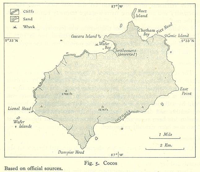
English: A map of Cocos Island (Isla del Coco), Costa Rica. The caption of the map is: "Fig. 5. Cocos / Based on official sources." |
| Date | |
| Source | Map Collection of the Perry-Castañeda Library, University of Texas. Originally from (1943) Pacific Islands: 2, Eastern Pacific, Nov. 1943 [Geographical handbook series; B.R. 519a], London: Naval Intelligence Division OCLC: 310446759. [1] |
| Author | Naval Intelligence Division, Admiralty (UK). |
Licensing
[edit]| Public domainPublic domainfalsefalse |
This work created by the United Kingdom Government is in the public domain.
This is because it is one of the following:
HMSO has declared that the expiry of Crown Copyrights applies worldwide (ref: HMSO Email Reply) Deutsch ∙ English ∙ Español ∙ français ∙ italiano ∙ Nederlands ∙ polski ∙ português ∙ sicilianu ∙ slovenščina ∙ suomi ∙ Türkçe ∙ македонски ∙ русский ∙ українська ∙ മലയാളം ∙ 한국어 ∙ 日本語 ∙ 简体中文 ∙ 繁體中文 ∙ العربية ∙ +/− |
 |
File history
Click on a date/time to view the file as it appeared at that time.
| Date/Time | Thumbnail | Dimensions | User | Comment | |
|---|---|---|---|---|---|
| current | 20:13, 12 October 2006 |  | 646 × 555 (77 KB) | Ratzer (talk | contribs) | http://www.lib.utexas.edu/maps/historical/pacific_islands_1943_1945/cocos.jpg http://www.lib.utexas.edu/usage_statement.html?maps=yes: "Most of the maps scanned by the University of Texas Libraries and served from this web site are in the public domain. |
| 20:12, 12 October 2006 |  | 646 × 555 (77 KB) | Ratzer (talk | contribs) | ||
| 20:09, 12 October 2006 |  | 646 × 555 (77 KB) | Ratzer (talk | contribs) | http://www.lib.utexas.edu/maps/historical/pacific_islands_1943_1945/cocos.jpg http://www.lib.utexas.edu/usage_statement.html?maps=yes: "Most of the maps scanned by the University of Texas Libraries and served from this web site are in the public domain. |
You cannot overwrite this file.
File usage on Commons
The following 2 pages use this file:
- Isla del Coco
- File:Cocos.jpg (file redirect)
File usage on other wikis
The following other wikis use this file:
- Usage on az.wikipedia.org
- Usage on bg.wikipedia.org
- Usage on ca.wikipedia.org
- Usage on cs.wikipedia.org
- Usage on de.wikipedia.org
- Usage on el.wikipedia.org
- Usage on en.wikipedia.org
- Usage on en.wikivoyage.org
- Usage on eo.wikipedia.org
- Usage on es.wikipedia.org
- Usage on frr.wikipedia.org
- Usage on fr.wikipedia.org
- Usage on gl.wikipedia.org
- Usage on he.wikipedia.org
- Usage on hr.wikipedia.org
- Usage on ja.wikipedia.org
- Usage on nn.wikipedia.org
- Usage on no.wikipedia.org
- Usage on pl.wikipedia.org
- Usage on ru.wikipedia.org
- Usage on sh.wikipedia.org
- Usage on uk.wikipedia.org
- Usage on vi.wikipedia.org
Metadata
This file contains additional information such as Exif metadata which may have been added by the digital camera, scanner, or software program used to create or digitize it. If the file has been modified from its original state, some details such as the timestamp may not fully reflect those of the original file. The timestamp is only as accurate as the clock in the camera, and it may be completely wrong.
| Orientation | Normal |
|---|---|
| Horizontal resolution | 150 dpi |
| Vertical resolution | 150 dpi |
| Software used | Adobe Photoshop 7.0 |
| File change date and time | 15:00, 25 March 2005 |
| Color space | Uncalibrated |
