File:Coal Mine Canyon (32937653597).jpg

Original file (7,191 × 4,815 pixels, file size: 27.84 MB, MIME type: image/jpeg)
Captions
Captions
Summary
[edit].jpg&action=edit§ion=1)
| Description |
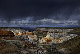
I cold have returned home from Kingman (no more traffic lights). But I had the thought that it would be nice to see Coal Mine Canyon, which was only a bit out of the way. So I turned north from Flagstaff and stopped at the Navajo Parks and Recreation Center in Cameron and paid $12.00 for a hiking and camping permit. A few miles past Tuba City, I saw the windmill on the hill and turned off the highway onto a dirt road. About half a mile later I stopped at the picnic area, which is near the rim of the canyon. There was another car parked nearby. A woman was walking around with a camera, but she soon left. I spent an hour walking along the rim and shooting down into the sunlit canyon. An occasional cloud would pass over, providing some variety to the light. Eventually the sky darkened in the northwest and serious rain squalls began to pass by. I got in the truck and drove to a location at the end of the canyon, which gave a great vantage point to watch the unfolding drama. I sat in the truck as patches of heavy rain passed through and jumped out to photograph the varying light playing down in the canyon between squalls. The ground quickly became slippery mud. But it was worth it. Eventually I drove over into the adjacent canyon, which is on Hopi land. The Hopis don’t allow photography anywhere on their reservation without the physical presence of a guide from the tribe. So you won’t see any photos from this beautiful canyon. I drove back to Coal Mine Canyon for the night. The next morning, I drove through the Hopi Reservation and picked up I-40 in Gallup. I arrived home late in the afternoon of Day 6 of my trip. |
| Date | |
| Source | Coal Mine Canyon |
| Author | John Fowler from Placitas, NM, USA |
| Camera location | | View this and other nearby images on: OpenStreetMap |
|---|
.jpg¶ms=036.010342_N_-111.046864_E_globe:Earth_type:camera_source:Flickr_&language=en)
Licensing
[edit].jpg&action=edit§ion=2)
- You are free:
- to share – to copy, distribute and transmit the work
- to remix – to adapt the work
- Under the following conditions:
- attribution – You must give appropriate credit, provide a link to the license, and indicate if changes were made. You may do so in any reasonable manner, but not in any way that suggests the licensor endorses you or your use.
| This image was originally posted to Flickr by snowpeak at https://flickr.com/photos/53986933@N00/32937653597 (archive). It was reviewed on 19 November 2019 by FlickreviewR 2 and was confirmed to be licensed under the terms of the cc-by-2.0. |
File history
Click on a date/time to view the file as it appeared at that time.
| Date/Time | Thumbnail | Dimensions | User | Comment | |
|---|---|---|---|---|---|
| current | 00:54, 19 November 2019 | | 7,191 × 4,815 (27.84 MB) | Noahedits (talk | contribs) | Transferred from Flickr via #flickr2commons |
You cannot overwrite this file.
File usage on Commons
The following page uses this file:
- File:Coal Mine Canyon, Tuba City, Arizona, U.S.A.jpg (file redirect)
.jpg&oldid=862661365)