File:CoalDNLBF.png
Jump to navigation
Jump to search
Size of this preview: 568 × 600 pixels. Other resolutions: 227 × 240 pixels | 454 × 480 pixels | 727 × 768 pixels | 1,263 × 1,334 pixels.
Original file (1,263 × 1,334 pixels, file size: 844 KB, MIME type: image/png)
Captions
Captions
Add a one-line explanation of what this file represents
Summary
[edit]
| Description |
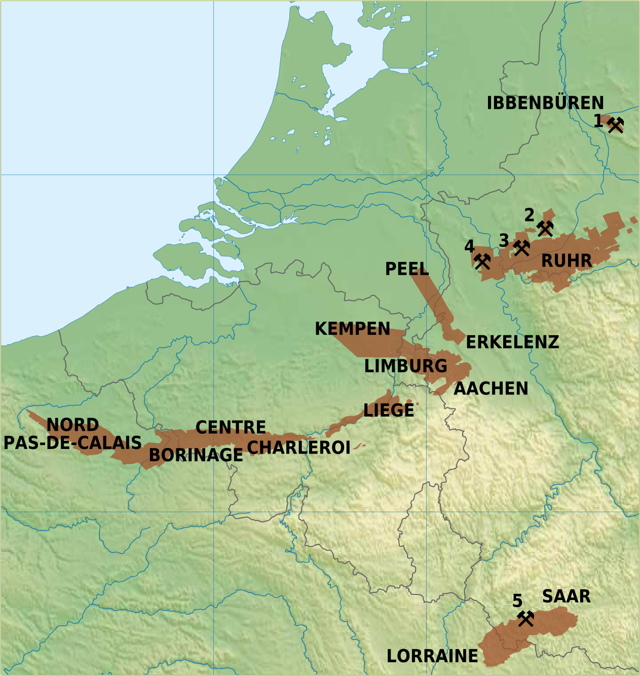
English: Overview map of coal mining areas in Belgium, Netherlands, Germany and Northern France
Nederlands: Overzicht van steenkoolmijngebieden in Belgie, Nederland, Duitsland en Noord-Frankrijk
Deutsch: Uebersichtskarte von Steinkohlrevieren in Belgien, Niederlande, Deutschland und Nord Frankreich
Français : Carte des zones de mines de charbon en Belgique, Pays-Bas, l'Allemagne et Nord de la France |
| Date | |
| Source | Own work |
| Author | Hans Erren |
Sources:
Germany: Ruhrkohle AG; Geologisches Landesamt Nordrhein-Westfalen, Krefeld; G Fettweis, 1953;  Ramana Rao Nunna, 1960
Netherlands: Rijks Geologische Dienst
Belgium: Kempense Steenkoolmijnen Zolder; Ministere de la Region Wallonne
France: Charbonnages de France

Active Coal Mines in 2012:
1: Bergwerk Ibbenbüren, Ibbenbüren (last coal 17 august 2018, closed 21 december 2018)
2: Zeche Auguste Viktoria, Marl (closed 18 december 2015)
3: Bergwerk Prosper-Haniel, Bottrop (closed 21 december 2018)
4: Bergwerk West, Kamp Lintfort (closed december 2012)
5: Bergwerk Saar, Saarlouis (closed june 2012)
I, the copyright holder of this work, hereby publish it under the following licenses:
| This file is licensed under the Creative Commons Attribution-Share Alike 3.0 Unported license. | ||
| ||
| This licensing tag was added to this file as part of the GFDL licensing update. |
The map has been created with the Generic Mapping Tools: https://www.generic-mapping-tools.org/ using one or more of these public-domain datasets for the relief:
|

|
Permission is granted to copy, distribute and/or modify this document under the terms of the GNU Free Documentation License, Version 1.2 or any later version published by the Free Software Foundation; with no Invariant Sections, no Front-Cover Texts, and no Back-Cover Texts. A copy of the license is included in the section entitled GNU Free Documentation License. |
You may select the license of your choice.
Licensing
[edit]
I, the copyright holder of this work, hereby publish it under the following licenses:
This file is licensed under the Creative Commons Attribution-Share Alike 3.0 Unported license.
- You are free:
- to share – to copy, distribute and transmit the work
- to remix – to adapt the work
- Under the following conditions:
- attribution – You must give appropriate credit, provide a link to the license, and indicate if changes were made. You may do so in any reasonable manner, but not in any way that suggests the licensor endorses you or your use.
- share alike – If you remix, transform, or build upon the material, you must distribute your contributions under the same or compatible license as the original.
|
|
Permission is granted to copy, distribute and/or modify this document under the terms of the GNU Free Documentation License, Version 1.2 or any later version published by the Free Software Foundation; with no Invariant Sections, no Front-Cover Texts, and no Back-Cover Texts. A copy of the license is included in the section entitled GNU Free Documentation License. |
You may select the license of your choice.
File history
Click on a date/time to view the file as it appeared at that time.
| Date/Time | Thumbnail | Dimensions | User | Comment | |
|---|---|---|---|---|---|
| current | 22:27, 2 January 2011 | | 1,263 × 1,334 (844 KB) | Hans Erren (talk | contribs) | border cropped |
| 21:52, 2 January 2011 |  | 1,291 × 1,363 (852 KB) | Hans Erren (talk | contribs) | {{Information |Description={{en|1=Overview map of coal mining areas in Belgium, Netherlands, Germany and Northern France}} {{nl|1=Overzicht van steenkoolmijngebieden in Belgie, Nederland, Duitsland en Noord-Frankrijk}} {{de|1=Uebersichtskarte von Steinkoh |
You cannot overwrite this file.
File usage on Commons
There are no pages that use this file.
File usage on other wikis
The following other wikis use this file:
- Usage on ar.wikipedia.org
- Usage on da.wikipedia.org
- Usage on de.wikipedia.org
- Usage on en.wikipedia.org
- Usage on fr.wikipedia.org
- Usage on li.wikipedia.org
- Usage on nl.wikipedia.org
- Usage on sr.wikipedia.org
- Usage on trv.wikipedia.org
- Usage on zh.wikipedia.org