File:Cloud Streets over the Great Lakes (MODIS 2022-01-13).jpg

Original file (5,709 × 4,292 pixels, file size: 3.64 MB, MIME type: image/jpeg)
Captions
Captions
Summary
[edit].jpg&action=edit§ion=1)
| Description |
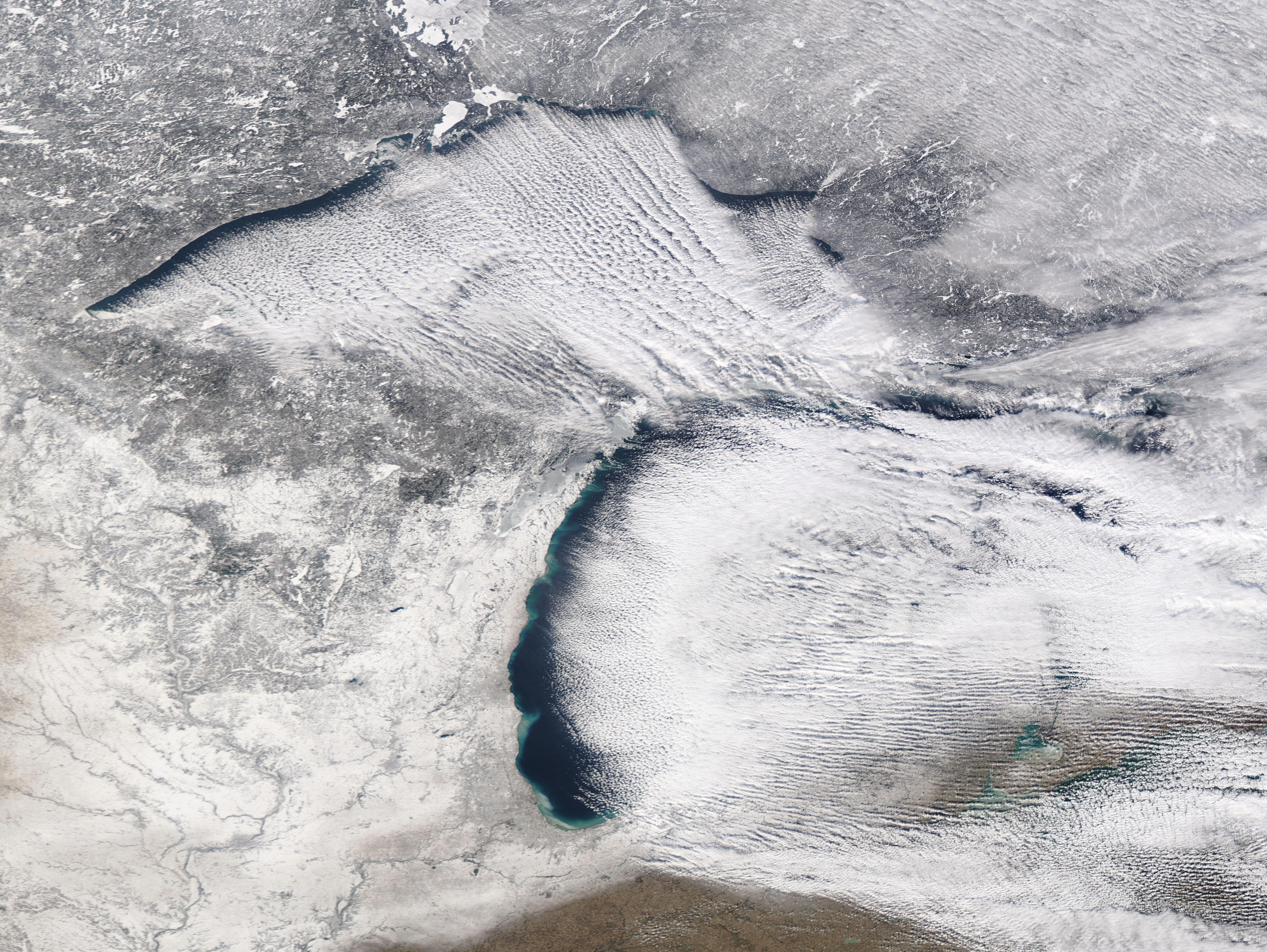
English: Frigid weather and strong winds collaborated to created spectacular cloud formations over two of the Great Lakes in early January 2022. The Moderate Resolution Imaging Spectroradiometer (MODIS) on board NASA’s Aqua satellite acquired a true-color image of the clouds over Lakes Superior and Michigan on January 10. The long rows of parallel white clouds—called “cloud streets”—are most clearly defined and dramatic over Lake Superior (north), but some also exist over Lake Michigan.
Clouds streets form when frigid, dry air blows across a relatively warmer body of water, such as the Great Lakes. As an air mass blows over cold land, it becomes cold and very dry. As this cold and dry air mass moves over the moist and warmer water of the lakes, it picks up water vapor to form clouds. When the air rises upward in columns (thermals), it carries heat away from the lake surface and becomes chilled as it rises. When this now-moist and chilled air meets a warmer air layer (a temperature inversion), the warmer layer acts like a lid and stops any more upward motion. The inversion causes the rising thermals to roll over on themselves, forming parallel cylinders of rotating air. On the upward side of the cylinders (rising air), water vapor condenses to form clouds. Along the downward side (descending air), skies remain clear. On January 9-10, a mass of frigid Arctic air blasted across the Great Lakes Region, causing temperatures to drop dramatically. The high temperature on January 10 in Thunder Bay, Ontario, Canada registered only -7˚F (-21˚C), while the low hit -21˚F (-29.4˚C). Thunder Bay sits on the northwestern shore of Lake Superior. On that same day Green Bay, on the western shore of Lake Michigan registered a warmer (but still frigid) high of 5˚F (-15˚C). |
||
| Date | Taken on 20 January 2022 | ||
| Source |
Cloud Streets over the Great Lakes (direct link)
|
||
| Author | MODIS Land Rapid Response Team, NASA GSFC |
| This media is a product of the Aqua mission Credit and attribution belongs to the mission team, if not already specified in the "author" row |
Licensing
[edit].jpg&action=edit§ion=2)
| This file is in the public domain in the United States because it was solely created by NASA. NASA copyright policy states that "NASA material is not protected by copyright unless noted". (See Template:PD-USGov, NASA copyright policy page or JPL Image Use Policy.) | ||
 |
Warnings:
|
File history
Click on a date/time to view the file as it appeared at that time.
| Date/Time | Thumbnail | Dimensions | User | Comment | |
|---|---|---|---|---|---|
| current | 22:22, 9 January 2024 | | 5,709 × 4,292 (3.64 MB) | OptimusPrimeBot (talk | contribs) | #Spacemedia - Upload of http://modis.gsfc.nasa.gov/gallery/images/image01132022_250m.jpg via Commons:Spacemedia |
You cannot overwrite this file.
File usage on Commons
There are no pages that use this file.
.jpg&oldid=909384958)