File:Clisson (Loire-Atlantique) (23853859220).jpg

Original file (4,928 × 3,264 pixels, file size: 7.51 MB, MIME type: image/jpeg)
Captions
Captions
Summary
[edit]_(23853859220).jpg&action=edit§ion=1)
| Description |
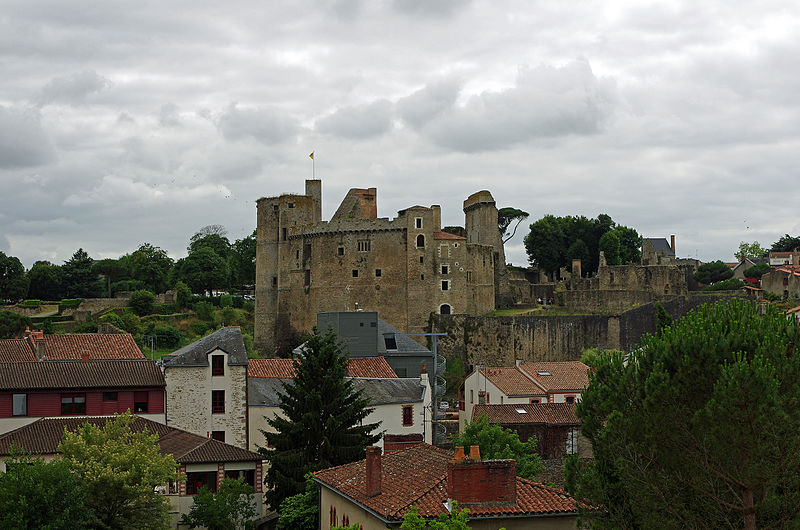
Clisson (Loire-Atlantique) Le château vu de l'Est. A gauche, les deux tours donjons accolées. Ensuite, logis, cuisine et oratoire. Plus à droite, les deux tours carrées des XIVe et XVIIème siècle. Enfin, à gauche, la porte principale nord avec le bastion terrassé nord. Le donjon est constitué de deux tours accolée à l'enceinte. La tour principale comprenait 5 étages et était résidentielle. La tour secondaire assurait les servitudes : aisance, stockage, etc. Avant l'incendie de 1793, les tours avaient des toits coniques. Les tours rectangulaires de la façade est datent du XIVe siècle pour la plus haute et du XVIIe pour la plus petite. La tour du XIVe est accolée au logis. La toiture des deux tours serait refaite par Lemot en 1809. La porte principale nord est située dans l'extension voulue par François II*, duc de Bretagne. Les toitures des maisons de Clisson sont clairement d'influence italienne. Au début du XIX ème siècle à l'arrivée des frères Pierre et François Cacault* (nantais d'origine) partent d'Irtalie et rentrent en France. Ils décident de s'installer à Clisson en 1798. Fortement marqués par la culture et l'architecture italienne, ils entreprennent une reconstruction de la ville, en ruines suite aux guerres de Vendée, sur le modèle toscan. Tuiles canal, briques minces, baies en arc en plein cintre. Un ami de François Cacault, le sculpteur François-Frédéric Lemot*, achète la garenne du château (ancienne réserve de chasse des Seigneurs de Clisson) en 1805 puis le château en 1807. Il y construit sa villa romaine, y aménage un parc.
|
| Date | |
| Source | Clisson (Loire-Atlantique) |
| Author | Daniel Jolivet |
| Camera location | | View this and other nearby images on: OpenStreetMap |
|---|
_(23853859220).jpg¶ms=047.087408_N_-001.276962_E_globe:Earth_type:camera_source:Flickr_&language=en)
Licensing
[edit]_(23853859220).jpg&action=edit§ion=2)
- You are free:
- to share – to copy, distribute and transmit the work
- to remix – to adapt the work
- Under the following conditions:
- attribution – You must give appropriate credit, provide a link to the license, and indicate if changes were made. You may do so in any reasonable manner, but not in any way that suggests the licensor endorses you or your use.
| This image was originally posted to Flickr by sybarite48 at https://flickr.com/photos/26082117@N07/23853859220. It was reviewed on 1 March 2016 by FlickreviewR and was confirmed to be licensed under the terms of the cc-by-2.0. |
File history
Click on a date/time to view the file as it appeared at that time.
| Date/Time | Thumbnail | Dimensions | User | Comment | |
|---|---|---|---|---|---|
| current | 13:43, 1 March 2016 | | 4,928 × 3,264 (7.51 MB) | 1Veertje (talk | contribs) | Transferred from Flickr via Flickr2Commons |
You cannot overwrite this file.
File usage on Commons
There are no pages that use this file.
_(23853859220).jpg&oldid=862218573)