File:Clegyr Boia, view east - geograph.org.uk - 738802.jpg
Jump to navigation
Jump to search
No higher resolution available.
Clegyr_Boia,_view_east_-_geograph.org.uk_-_738802.jpg (640 × 480 pixels, file size: 128 KB, MIME type: image/jpeg)
Captions
Captions
Add a one-line explanation of what this file represents
Summary
[edit]
| Description |
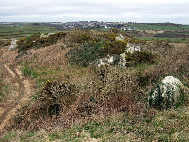
English: Clegyr Boia, view east The eastern end of the hillfort/rock mound looking over to the city of St David's clustered around the cathedral at its core, the lowest point.
The legend is that Boia, the local chieftain in St David's time, using this outcrop as his vantage point "with invidious malignity overlooked the anchorite's calm retirement" (Richard Fenton, 1811)until he was himself slain by a rival. The word Clegyr means cairn or stony place. |
| Date | |
| Source | From geograph.org.uk |
| Author | ceridwen |
| Attribution (required by the license) | ceridwen / Clegyr Boia, view east / |
| Camera location | | View this and other nearby images on: OpenStreetMap |
|---|
_heading:90.00&language=en)
| Object location | | View this and other nearby images on: OpenStreetMap |
|---|
_heading:90.00&language=en)
Licensing
[edit]

|
This image was taken from the Geograph project collection. See this photograph's page on the Geograph website for the photographer's contact details. The copyright on this image is owned by ceridwen and is licensed for reuse under the Creative Commons Attribution-ShareAlike 2.0 license.
|
This file is licensed under the Creative Commons Attribution-Share Alike 2.0 Generic license.
Attribution: ceridwen
- You are free:
- to share – to copy, distribute and transmit the work
- to remix – to adapt the work
- Under the following conditions:
- attribution – You must give appropriate credit, provide a link to the license, and indicate if changes were made. You may do so in any reasonable manner, but not in any way that suggests the licensor endorses you or your use.
- share alike – If you remix, transform, or build upon the material, you must distribute your contributions under the same or compatible license as the original.
File history
Click on a date/time to view the file as it appeared at that time.
| Date/Time | Thumbnail | Dimensions | User | Comment | |
|---|---|---|---|---|---|
| current | 07:34, 19 February 2011 | | 640 × 480 (128 KB) | GeographBot (talk | contribs) | == {{int:filedesc}} == {{Information |description={{en|1=Clegyr Boia, view east The eastern end of the hillfort/rock mound looking over to the city of St David's clustered around the cathedral at its core, the lowest point. The legend is that Boia, the l |
You cannot overwrite this file.
File usage on Commons
There are no pages that use this file.
File usage on other wikis
The following other wikis use this file:
- Usage on cy.wikipedia.org
- Usage on en.wikipedia.org
- Usage on www.wikidata.org