File:Claudette 2015 track.png
Jump to navigation
Jump to search
Size of this preview: 800 × 495 pixels. Other resolutions: 320 × 198 pixels | 640 × 396 pixels | 1,024 × 633 pixels | 1,280 × 791 pixels | 2,700 × 1,669 pixels.
Original file (2,700 × 1,669 pixels, file size: 2.74 MB, MIME type: image/png)
Captions
Captions
Add a one-line explanation of what this file represents
Summary
| Description |
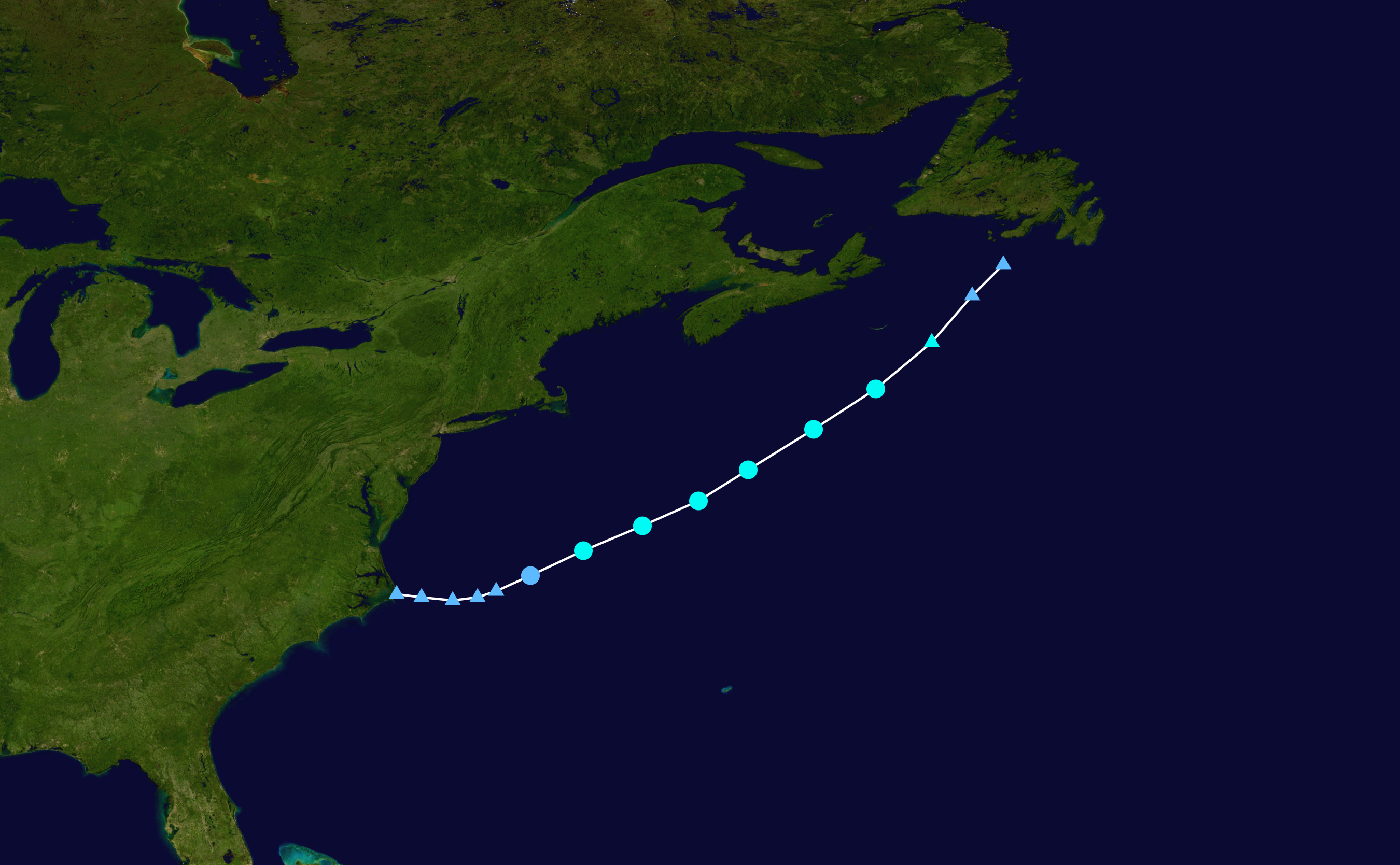
English: Track map of Tropical Storm Claudette of the 2015 Atlantic hurricane season. The points show the location of the storm at 6-hour intervals. The colour represents the storm's maximum sustained wind speeds as classified in the (see below), and the shape of the data points represent the nature of the storm, according to the legend below. Tropical depression (≤38 mph, ≤62 km/h)
Tropical storm (39–73 mph, 63–118 km/h)
Category 1 (74–95 mph, 119–153 km/h)
Category 2 (96–110 mph, 154–177 km/h)
Category 3 (111–129 mph, 178–208 km/h)
Category 4 (130–156 mph, 209–251 km/h)
Category 5 (≥157 mph, ≥252 km/h)
Unknown
Storm type |
||
| Date | 2015-07-12–2015-07-14 | ||
| Source | Created by Cyclonebiskit using Wikipedia:WikiProject Tropical cyclones/Tracks. The background image is from NASA. Tracking data is from the National Hurricane Center[1]. | ||
| Author | Cyclonebiskit | ||
| Source code | Track map data table, if present below, is in HURDAT2 or ATCF format. See format details in [2] and [3], respectively.
|
Licensing
[edit]| This work has been released into the public domain by its author, Cyclonebiskit. This applies worldwide. In some countries this may not be legally possible; if so: Cyclonebiskit grants anyone the right to use this work for any purpose, without any conditions, unless such conditions are required by law. |
File history
Click on a date/time to view the file as it appeared at that time.
| Date/Time | Thumbnail | Dimensions | User | Comment | |
|---|---|---|---|---|---|
| current | 19:57, 18 August 2015 | | 2,700 × 1,669 (2.74 MB) | Supportstorm (talk | contribs) | Added missing point |
| 17:08, 17 August 2015 |  | 2,700 × 1,669 (2.69 MB) | Supportstorm (talk | contribs) | Best track | |
| 05:08, 21 July 2015 |  | 2,000 × 1,236 (2.03 MB) | Cyclonebiskit (talk | contribs) | It's the same issue as Ana, the OPC will follow systems as lows even if they're not closed (NHC discontinues tracks when lows open up). This is to avoid misleading information when there are uncertainties. | |
| 22:01, 20 July 2015 |  | 2,700 × 1,764 (3.38 MB) | Supportstorm (talk | contribs) | rv:OPC is the WMO metarea for this area and has higher jurisdiction over the CHC. OPC explicitly stated this low was EX-Claudette. | |
| 06:52, 20 July 2015 |  | 2,000 × 1,236 (2.03 MB) | Cyclonebiskit (talk | contribs) | Canadian Hurricane Center is very clear about the center all but dissipating...I don't feel comfortable using OPC points (which do include non-closed lows) when accounting for the CHC's analysis. | |
| 21:31, 19 July 2015 |  | 2,700 × 1,764 (3.38 MB) | Supportstorm (talk | contribs) | Final operational update | |
| 16:37, 18 July 2015 |  | 2,700 × 1,764 (3.38 MB) | Supportstorm (talk | contribs) | 07/18 12Z update | |
| 22:06, 16 July 2015 |  | 2,700 × 1,669 (2.96 MB) | Supportstorm (talk | contribs) | 07/16 18Z OPC data | |
| 23:25, 15 July 2015 |  | 2,000 × 1,236 (2.03 MB) | Cyclonebiskit (talk | contribs) | Final position from the CHC | |
| 03:13, 15 July 2015 |  | 2,000 × 1,236 (1.98 MB) | Cyclonebiskit (talk | contribs) | {{WPTC track map | author = Cyclonebiskit | name = Tropical Storm Claudette | article = Tropical Storm Claudette (2015) | season = 2015 Atlantic hurricane season | start = 2015-07-11 | end = 2015-07-15 | othersource=[ftp://ftp.emc.ncep.noaa.gov/... |
You cannot overwrite this file.
File usage on Commons
There are no pages that use this file.
File usage on other wikis
The following other wikis use this file:
- Usage on de.wikipedia.org
- Usage on es.wikipedia.org
- Usage on fr.wikipedia.org
- Usage on ko.wikipedia.org
- Usage on pt.wikipedia.org
- Usage on th.wikipedia.org
- Usage on zh.wikipedia.org