File:Citylinkmap2.svg
Jump to navigation
Jump to search

Size of this PNG preview of this SVG file: 752 × 496 pixels. Other resolutions: 320 × 211 pixels | 640 × 422 pixels | 1,024 × 675 pixels | 1,280 × 844 pixels | 2,560 × 1,689 pixels.
Original file (SVG file, nominally 752 × 496 pixels, file size: 30 KB)
Captions
Captions
Add a one-line explanation of what this file represents
Summary
[edit]
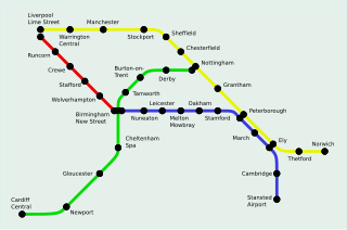
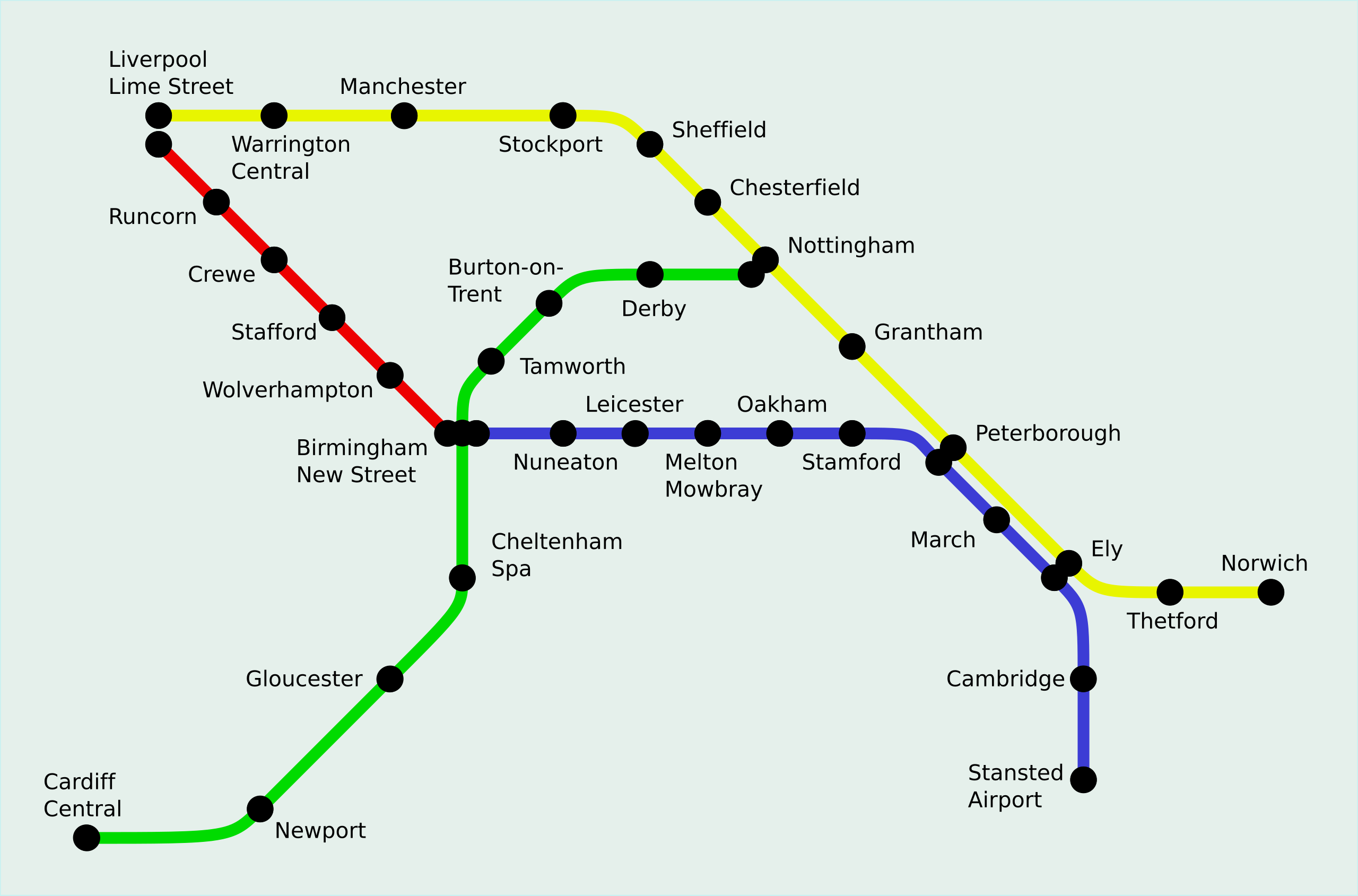
| Description | Diagram of the 30 English stations and 2 Welsh stations served by Central Trains' backbone of licensed routes: Citylink. At six stations its red, blue, yellow and green routes intersect, three of which (Peterborough, March and Ely) are uniquely where two routes overlap (yellow and blue). |
| Date | |
| Source | self-made, from information found on the Citylink website |
| Author | Time3000 |
| Other versions | Image:Citylinkmap3.svg |
Licensing
[edit]
| This work has been released into the public domain by its author, I, Time3000. This applies worldwide. In some countries this may not be legally possible; if so: I, Time3000 grants anyone the right to use this work for any purpose, without any conditions, unless such conditions are required by law. |
File history
Click on a date/time to view the file as it appeared at that time.
| Date/Time | Thumbnail | Dimensions | User | Comment | |
|---|---|---|---|---|---|
| current | 22:00, 4 September 2015 | | 752 × 496 (30 KB) | Delta 51 (talk | contribs) | final try |
| 20:45, 4 September 2015 |  | 752 × 496 (30 KB) | Delta 51 (talk | contribs) | another attempt | |
| 20:41, 4 September 2015 |  | 752 × 496 (30 KB) | Delta 51 (talk | contribs) | and another... | |
| 20:29, 4 September 2015 |  | 752 × 496 (35 KB) | Delta 51 (talk | contribs) | another attempt | |
| 20:28, 4 September 2015 |  | 752 × 496 (37 KB) | Delta 51 (talk | contribs) | Reverted to version as of 18:59, 21 July 2007 | |
| 20:28, 4 September 2015 |  | 752 × 496 (34 KB) | Delta 51 (talk | contribs) | improved colours and, hopefully, fixed PNG rendering bug | |
| 18:59, 21 July 2007 |  | 752 × 496 (37 KB) | Cronholm144 (talk | contribs) | dots | |
| 02:17, 21 July 2007 |  | 752 × 496 (13 KB) | CountingPine (talk | contribs) | Fix dots? | |
| 02:12, 21 July 2007 |  | 752 × 496 (13 KB) | CountingPine (talk | contribs) | New version, more closely following the geography | |
| 15:34, 10 July 2007 |  | 1,300 × 630 (7 KB) | Time3000~commonswiki (talk | contribs) |
You cannot overwrite this file.
File usage on Commons
The following 3 pages use this file:
File usage on other wikis
The following other wikis use this file:
- Usage on en.wikipedia.org
- Usage on pl.wikipedia.org