File:City of London map 01.jpg
Jump to navigation
Jump to search
Size of this preview: 773 × 600 pixels. Other resolutions: 309 × 240 pixels | 619 × 480 pixels | 990 × 768 pixels | 1,280 × 993 pixels | 2,560 × 1,987 pixels | 4,778 × 3,708 pixels.
Original file (4,778 × 3,708 pixels, file size: 815 KB, MIME type: image/jpeg)
Captions
Captions
Add a one-line explanation of what this file represents
Summary
[edit]

|
File:City of London map 01.svg is a vector version of this file. It should be used in place of this JPG file when not inferior.
File:City of London map 01.jpg → File:City of London map 01.svg
For more information, see Help:SVG. |
 |
| Description |
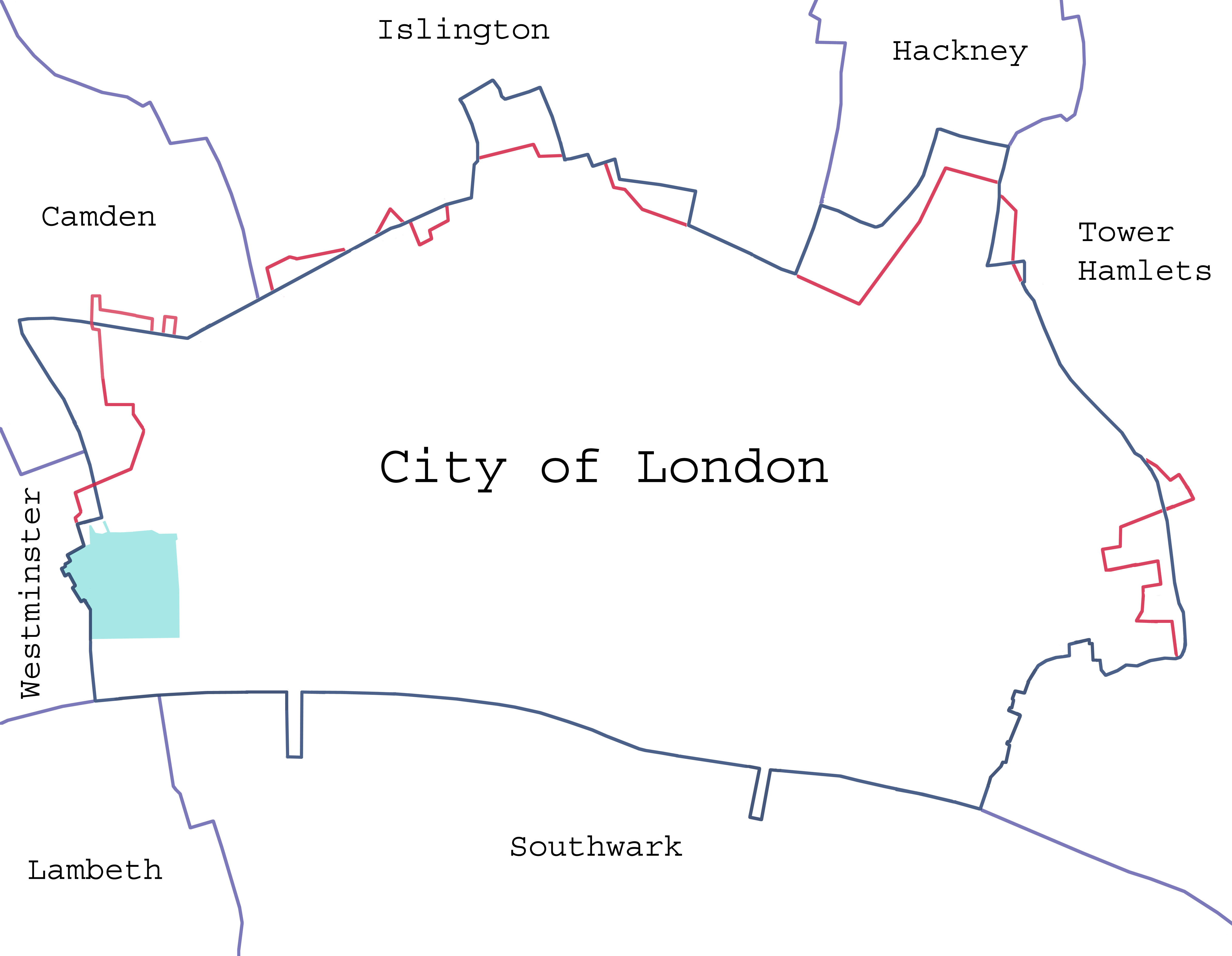
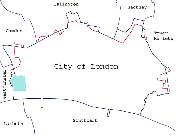
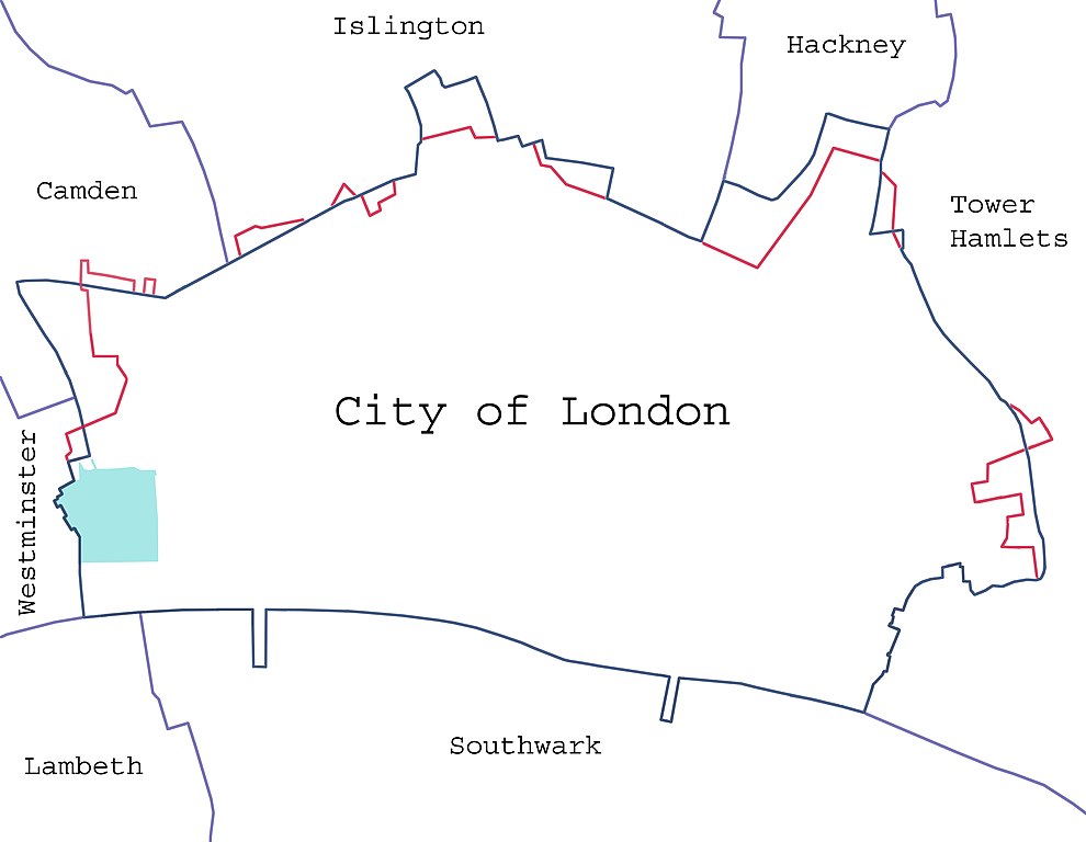
Català: Límits de la Ciutat de Londres en blau i els límits anteriors al 1993 en vermell.
Deutsch: Ausdehnung der City of London; die Grenze vor 1993 ist rot markiert, der Inner Temple und der Middle Temple grün.
English: Borders of the City of London, showing surrounding London boroughs and the pre-1994 boundary (where changed). The area covered by the Inner and Middle Temple is marked.
Español: Límites de la City.
Magyar: A City jelenlegi és 1993. előtti határai, szomszédos kerületei. Az Inner és Middle Temple által elfoglalt területeket is jelzi a térkép. English: Map of the en:City of London, showing surrounding London Boroughs and the pre-1993 boundary (where changed) in red. The area covered by the Inner and Middle Temples is shown in light green. |
| Date |
23 January 2008 (original upload date) |
| Source | Own work (Original text: self-made) |
| Author |
Dpaajones at English Wikipedia |
| Permission (Reusing this file) |
Yes; note that the map has been created with data from en:Ordnance Survey. |
Licensing
[edit]
Dpaajones at English Wikipedia, the copyright holder of this work, hereby publishes it under the following licenses:

|
Permission is granted to copy, distribute and/or modify this document under the terms of the GNU Free Documentation License, Version 1.2 or any later version published by the Free Software Foundation; with no Invariant Sections, no Front-Cover Texts, and no Back-Cover Texts. A copy of the license is included in the section entitled GNU Free Documentation License. |
This file is licensed under the Creative Commons Attribution-Share Alike 3.0 Unported, 2.5 Generic, 2.0 Generic and 1.0 Generic license.
Attribution: Dpaajones at English Wikipedia
- You are free:
- to share – to copy, distribute and transmit the work
- to remix – to adapt the work
- Under the following conditions:
- attribution – You must give appropriate credit, provide a link to the license, and indicate if changes were made. You may do so in any reasonable manner, but not in any way that suggests the licensor endorses you or your use.
- share alike – If you remix, transform, or build upon the material, you must distribute your contributions under the same or compatible license as the original.
You may select the license of your choice.
Original upload log
[edit]
The original description page was here. All following user names refer to en.wikipedia.
- 2008-01-24 14:20 Dpaajones 4778×3708×8 (834539 bytes) {{Information |Description=Map of the [[City of London]], showing surrounding London Boroughs and the pre-1993 boundary (where changed) in red. The area coverd by the Inner and Middle Temples is shown in light green. |Source=self-made |Date=January 2008 |
- 2008-01-24 14:16 Dpaajones 4778×3708×8 (834539 bytes) {{Information |Description=Map of the [[City of London]], showing surrounding London Boroughs and the pre-1993 boundary (where changed) in red. The area coverd by the Inner and Middle Temples is shown in light green. |Source=self-made |Date=January 2008 |
- 2008-01-23 22:38 Dpaajones 4778×3708×8 (828891 bytes) {{Information |Description=Map of the [[City of London]], showing surrounding London Boroughs and the pre-1993 boundary (where changed) |Source=self-made |Date=January 2008 |Location=City of London, London |Author=Mr David Philip Jones |Permission=yes |ot
File history
Click on a date/time to view the file as it appeared at that time.
| Date/Time | Thumbnail | Dimensions | User | Comment | |
|---|---|---|---|---|---|
| current | 22:44, 6 February 2008 | | 4,778 × 3,708 (815 KB) | Pacoperez6 (talk | contribs) | {{Information |Description={{en|Map of the en:City of London, showing surrounding London Boroughs and the pre-1993 boundary (where changed) in red. The area covered by the Inner and Middle Temples is shown in light green.}} |Source=Transferred from [ |
You cannot overwrite this file.
File usage on Commons
There are no pages that use this file.
File usage on other wikis
The following other wikis use this file:
- Usage on ca.wikipedia.org
- Usage on es.wikipedia.org
- Usage on hu.wikipedia.org