File:City map stavanger.png
Jump to navigation
Jump to search

Size of this preview: 424 × 599 pixels. Other resolutions: 170 × 240 pixels | 340 × 480 pixels | 544 × 768 pixels | 725 × 1,024 pixels | 2,124 × 3,000 pixels.
Original file (2,124 × 3,000 pixels, file size: 1.92 MB, MIME type: image/png)
Captions
Captions
Add a one-line explanation of what this file represents
Summary
[edit]
| Description |
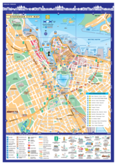
English: City Map Stavanger Norway |
| Date | |
| Source | Own work |
| Author | Kevinpaulscarrott |
| Permission (Reusing this file) |
| Camera location | | View this and other nearby images on: OpenStreetMap |
|---|
WGS84: 58° 57 48 N, 5° 43 8 E (58.963333, 5.718889)
Licensing
[edit]
I, the copyright holder of this work, hereby publish it under the following license:
This file is licensed under the Creative Commons Attribution-Share Alike 4.0 International license.
- You are free:
- to share – to copy, distribute and transmit the work
- to remix – to adapt the work
- Under the following conditions:
- attribution – You must give appropriate credit, provide a link to the license, and indicate if changes were made. You may do so in any reasonable manner, but not in any way that suggests the licensor endorses you or your use.
- share alike – If you remix, transform, or build upon the material, you must distribute your contributions under the same or compatible license as the original.
File history
Click on a date/time to view the file as it appeared at that time.
| Date/Time | Thumbnail | Dimensions | User | Comment | |
|---|---|---|---|---|---|
| current | 09:59, 13 May 2022 | | 2,124 × 3,000 (1.92 MB) | Kevinpaulscarrott (talk | contribs) | Update: Latest version 12 05 2022 Accommodation & Transport |
| 16:37, 6 April 2019 |  | 2,102 × 3,008 (2.46 MB) | Kevinpaulscarrott (talk | contribs) | Update: Consulates in Stavanger 2019 | |
| 14:03, 1 April 2019 |  | 3,009 × 4,305 (3.81 MB) | Kevinpaulscarrott (talk | contribs) | UPDATE: FARGEGATEN (Street of Colour) ØVRE HOLMEGATE | |
| 12:07, 13 March 2019 |  | 2,101 × 3,006 (2.46 MB) | Kevinpaulscarrott (talk | contribs) | 2019 Version. 3008 pixelː Wikivoyage Mapmaking Expedition | |
| 21:53, 16 January 2018 |  | 2,101 × 3,006 (2.49 MB) | Kevinpaulscarrott (talk | contribs) | 3008 pixelː Wikivoyage Mapmaking Expedition | |
| 21:47, 15 January 2018 |  | 1,250 × 1,789 (1.29 MB) | Kevinpaulscarrott (talk | contribs) | Updateː removed QR-code | |
| 16:29, 15 January 2018 |  | 1,250 × 1,789 (1.3 MB) | Kevinpaulscarrott (talk | contribs) | 2018 version | |
| 19:47, 2 January 2017 |  | 1,250 × 1,789 (1.24 MB) | Kevinpaulscarrott (talk | contribs) | 2017 version | |
| 11:34, 2 October 2016 |  | 1,250 × 1,789 (1.24 MB) | Kevinpaulscarrott (talk | contribs) | Tourist Information Office has moved from Domkirkeplassen to STRANDKAIEN (cruise ship Pier) | |
| 13:19, 2 March 2016 |  | 1,250 × 1,789 (1.24 MB) | Kevinpaulscarrott (talk | contribs) | 2016 Version |
You cannot overwrite this file.
File usage on Commons
The following 3 pages use this file:
File usage on other wikis
The following other wikis use this file:
- Usage on el.wikipedia.org
- Usage on en.wikipedia.org