File:City Lights 2012 - Flat map crop.jpg
Jump to navigation
Jump to search

Size of this preview: 800 × 428 pixels. Other resolutions: 320 × 171 pixels | 640 × 342 pixels | 1,024 × 548 pixels | 1,280 × 685 pixels | 2,560 × 1,369 pixels | 11,358 × 6,075 pixels.
Original file (11,358 × 6,075 pixels, file size: 5.11 MB, MIME type: image/jpeg)
Captions
Captions
Add a one-line explanation of what this file represents
Summary
[edit]
| Warning | The original file is very high-resolution. It might not load properly or could cause your browser to freeze when opened at full size. |
|---|
Summary
[edit]
| Description |
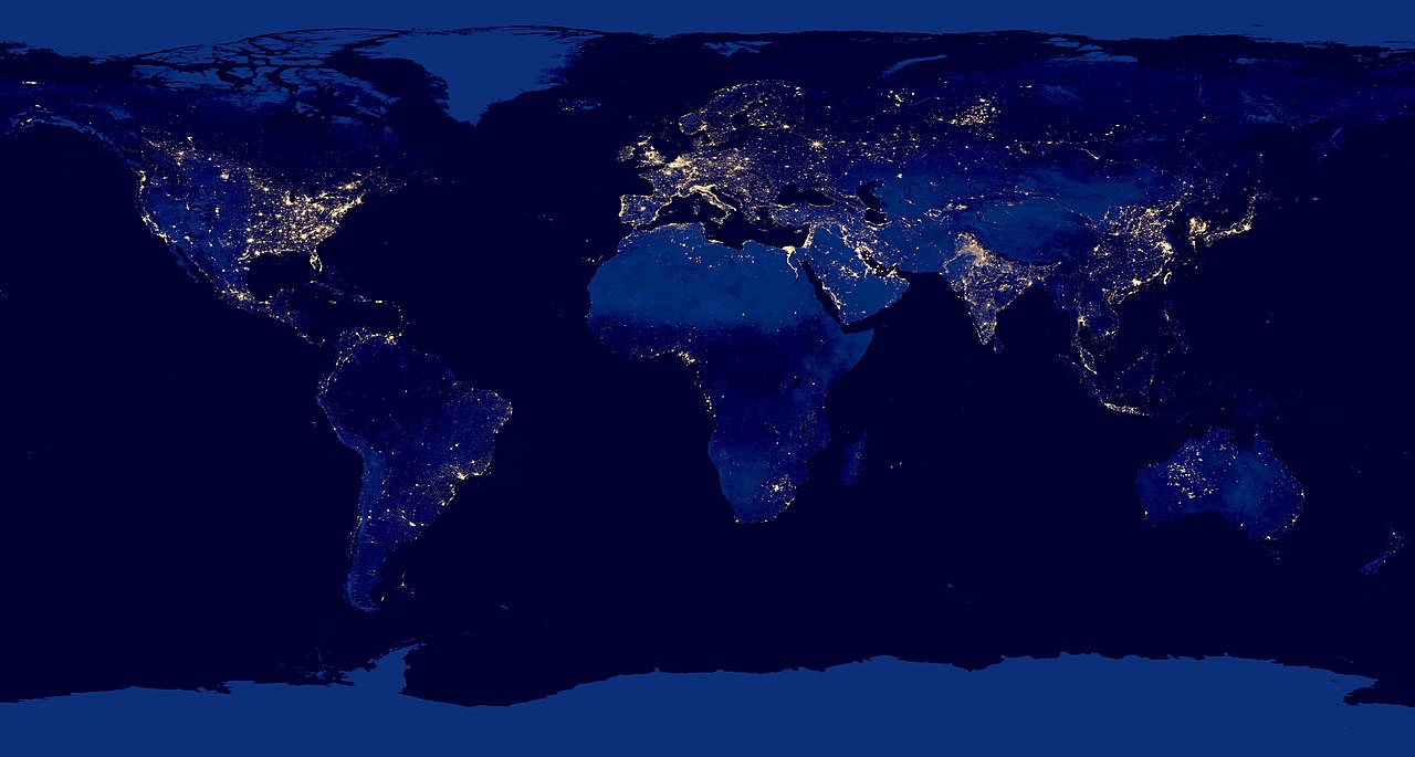
English: Composite view of Earth at night from the Suomi NPP satellite in polar orbit 512 miles above the surface, from April 18, over nine days and for 13 days ending October 23, 2012. |
| Date | |
| Source | http://www.nasa.gov/mission_pages/NPP/news/earth-at-night.html |
| Author | NASA Earth Observatory |
| Other versions | File:City Lights 2012 - Flat map.jpg |
Licensing
[edit]
| This file is in the public domain in the United States because it was solely created by NASA. NASA copyright policy states that "NASA material is not protected by copyright unless noted". (See Template:PD-USGov, NASA copyright policy page or JPL Image Use Policy.) | ||
 |
Warnings:
|
File history
Click on a date/time to view the file as it appeared at that time.
| Date/Time | Thumbnail | Dimensions | User | Comment | |
|---|---|---|---|---|---|
| current | 23:51, 20 March 2019 | | 11,358 × 6,075 (5.11 MB) | Materialscientist (talk | contribs) | {{LargeImage}} =={{int:filedesc}}== {{Information |description={{en|1=Composite view of Earth at night from the Suomi NPP satellite in polar orbit 512 miles above the surface, from April 18, over nine days and for 13 days ending October 23, 2012.}} |date=2012-12-06 |source=http://www.nasa.gov/mission_pages/NPP/news/earth-at-night.html |author=NASA Earth Observatory |permission= |other_versions=File:City Lights 2012 - Flat map.jpg |other_fields= }} =={{int:license-header}}== {{PD-USGov-... |
You cannot overwrite this file.
File usage on Commons
The following page uses this file:
File usage on other wikis
The following other wikis use this file:
- Usage on ar.wikipedia.org
- Usage on bg.wikipedia.org
- Usage on en.wikipedia.org
- Usage on fa.wikipedia.org
- Usage on pt.wikipedia.org