File:Circuito Melilla (Montevideo, Uruguay).png
Circuito_Melilla_(Montevideo,_Uruguay).png (593 × 580 pixels, file size: 202 KB, MIME type: image/png)
Captions
Captions
Summary
[edit]| DescriptionCircuito Melilla (Montevideo, Uruguay).png |
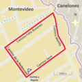
Español: Circuito en caminos de Melilla, en el noroeste de Montevideo, Uruguay. Es utilizado para competencias de ciclismo. Trazado de 11 kilómetros de extensión delimitado por el Camino Seré, el Camino de la Redención, el Camino Félix Buxareo y el Camino Melilla. Partida y llegada frente a la sede del Club Juventud Melilla, en Camino Seré 2049.
Imagen original: https://tools.wmflabs.org Modificaciones a cargo de Hυgo.
English: Circuit paths Melilla, in the northwest of Montevideo, Uruguay. It is used for cycling competitions. Plotting of 11 kilometers bounded by the Sere, the Path of Redemption Way, the Way Felix Buxareo and Melilla Way. Departure and outside the headquarters of the Youth Club Melilla, Camino Seré 2049.
Original image: https://tools.wmflabs.org/ Modifications by Hυgo.
Português: Caminhos do circuito Melilla, no noroeste de Montevidéu, Uruguai. Ele é usado para competições de ciclismo. Trama de 11 km delimitadas pelo Sere, o Caminho da Redenção caminho, o caminho Felix Buxareo e Melilla Way. Partida e em frente à sede do Juventude Clube Melilla, Camino Seré 2049.
Imagem original: https://tools.wmflabs.org/ Modificações por Hυgo
Français : Chemins de circuits Melilla, dans le nord-ouest de Montevideo, Uruguay. Il est utilisé pour des compétitions cyclistes. Tracé des 11 km délimitée par les Sere, le Chemin de la rédemption Way, la Voie Felix Buxareo et Melilla Way. Départ et devant le siège du Club Jeunesse Melilla, Camino Seré 2049.
Image d'origine: https://tools.wmflabs.org/ Modifications par Hυgo.
Italiano: Percorsi circuito Melilla, nel nord-ovest di Montevideo, in Uruguay. E 'utilizzato per le competizioni ciclistiche. Rappresentazione grafica di 11 km delimitate dal Sere, il Sentiero della Redenzione Way, la Via Felix Buxareo e Melilla Way. Partenza e davanti alla sede della Gioventù Club Melilla, Camino'll Seré 2.049.
Immagine originale: https://tools.wmflabs.org/ Modifiche di Hυgo
Nederlands: Circuitpaden Melilla, in het noordwesten van Montevideo, Uruguay. Het wordt gebruikt voor wielerwedstrijden. Plotten van 11 kilometer begrensd door de Sere, het Pad van Verlossing weg, de weg Felix Buxareo en Melilla Way. Vertrek en buiten het hoofdkwartier van de Youth Club Melilla, Camino'll Seré 2049.
Oorspronkelijke afbeelding: https://tools.wmflabs.org/ Wijzigingen door Hυgo
Deutsch: Leiterbahnen Melilla, im Nordwesten von Montevideo, Uruguay. Es ist für den Radsport-Wettbewerbe verwendet. Plotten von 11 Kilometer von der Sere, dem Pfad der Erlösung Weg, den Weg Felix Buxareo und Melilla Way begrenzt. Abfahrt und vor dem Sitz der Youth Club Melilla, Camino'll 2049 sein.
Originalbild: https://tools.wmflabs.org/ Änderungen durch Hυgo
Polski: Ścieżki obwodu Melilla, w północno-zachodniej Montevideo, Urugwaj. Stosuje się go do udziału w zawodach rowerowych. Wykreślanie z 11 km ograniczonych przez Sère, Ścieżki Wykup drogę, drogę Felix Buxareo i Melilla Way. Wyjazdu i poza siedzibą Młodzieżowego Klubu Melilli, Camino'll być 2049.
Modyfikacje by Hυgo
Русский: Автоматические пути Мелилья на северо-западе Монтевидео, Уругвай. Он используется для езды на велосипеде соревнований. Нанесение 11 километров, ограниченных Сере, путь искупления, так, как Феликс Buxareo и Мелилья пути. Выезд и за ее пределами штаб-квартиры молодежного клуба Мелилья, Camino'll быть 2049.
Изменения по Hυgo
日本語: 回路経路メリリャ、モンテビデオ、ウルグアイの北西で。これは、サイクリング競技のために使用される。セレで囲まれた11キロ、償還ウェイの道、道フェリックスBuxareoとメリリャウェイのプロット。出発地と青少年クラブメリリャの本部の外に、2049年もCamino'll。
元の画像:https://tools.wmflabs.org/ 改変によって Hυgo
العربية: مسارات الدائرة مليلية، في شمال غرب مونتيفيديو، أوروغواي. فهو يستخدم لمسابقات ركوب الدراجات. بالتآمر من 11 كيلو مترا يحدها من قبل سيري، طريق الخلاص الطريق والطريق فيليكس Buxareo ومليلية الطريق. رحيل وخارج مقر نادي مليلية الشباب، Cami
https://tools.wmflabs.org/ :الصورة الأصلية Hυgo تعديلات من قبل |
| Date | |
| Source | https://tools.wmflabs.org |
| Author | © Colaboradores de OpenStreetMap. Modificaciones a cargo de Hυgo. |
Licensing
[edit]
|
This work contains information from OpenStreetMap, which is made available under the Open Database License (ODbL).
The ODbL does not require any particular license for maps produced from ODbL data. Prior to 1 August 2020, map tiles produced by the OpenStreetMap Foundation were licensed under the CC-BY-SA-2.0 license. Maps produced by other people may be subject to other licences.Open Database LicenseODbLhttp://opendatacommons.org/licenses/odbl/1.0/true |
- You are free:
- to share – to copy, distribute and transmit the work
- to remix – to adapt the work
- Under the following conditions:
- attribution – You must give appropriate credit, provide a link to the license, and indicate if changes were made. You may do so in any reasonable manner, but not in any way that suggests the licensor endorses you or your use.
- share alike – If you remix, transform, or build upon the material, you must distribute your contributions under the same or compatible license as the original.
File history
Click on a date/time to view the file as it appeared at that time.
| Date/Time | Thumbnail | Dimensions | User | Comment | |
|---|---|---|---|---|---|
| current | 22:06, 29 March 2016 |  | 593 × 580 (202 KB) | Hυgo (talk | contribs) | Mejoras / Improvements |
| 00:27, 21 April 2015 |  | 1,114 × 1,114 (1.12 MB) | Hυgo (talk | contribs) | User created page with UploadWizard |
You cannot overwrite this file.
File usage on Commons
The following 4 pages use this file:
File usage on other wikis
The following other wikis use this file:
- Usage on es.wikipedia.org
Metadata
This file contains additional information such as Exif metadata which may have been added by the digital camera, scanner, or software program used to create or digitize it. If the file has been modified from its original state, some details such as the timestamp may not fully reflect those of the original file. The timestamp is only as accurate as the clock in the camera, and it may be completely wrong.
| Horizontal resolution | 35.43 dpc |
|---|---|
| Vertical resolution | 35.43 dpc |
| Software used |
