File:Circo y cima de Peñalara1.JPG
Jump to navigation
Jump to search
Size of this preview: 800 × 600 pixels. Other resolutions: 320 × 240 pixels | 640 × 480 pixels | 1,024 × 768 pixels | 1,280 × 960 pixels.
Original file (1,280 × 960 pixels, file size: 348 KB, MIME type: image/jpeg)
Captions
Captions
Add a one-line explanation of what this file represents
Summary
[edit]
| Description |
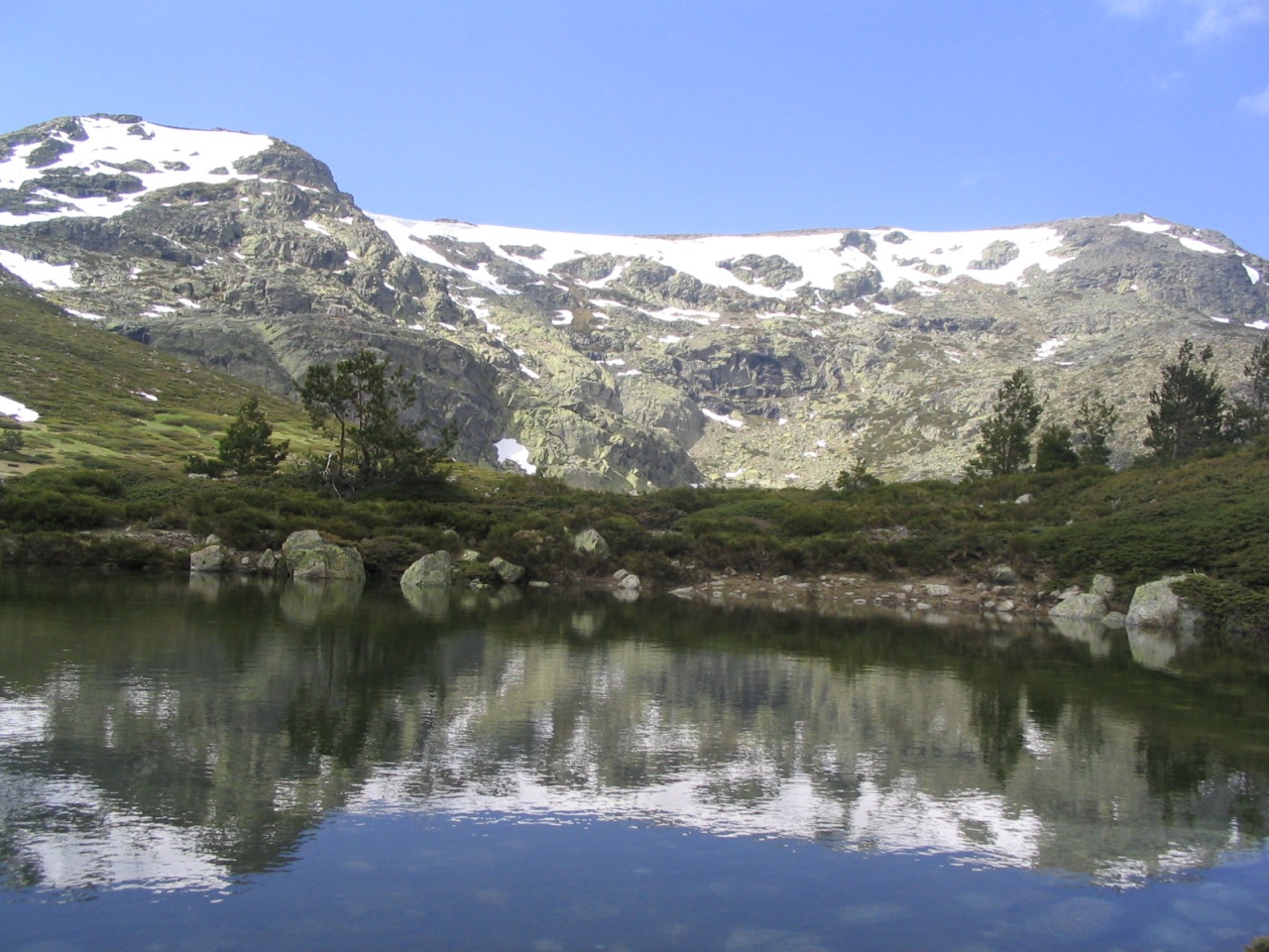
Español: Vista del circo de Peñalara y su reflejo en una pequeña laguna (2.005 m). Tanto este circo como la laguna son de origen glaciar, al igual que las más de veinte pequeñas lagunas que salpican el Parque Natural de Peñalara. Este circo glaciar es una de las formaciones glaciares más importantes de la Sierra de Guadarrama y del Sistema Central (cordillera a la que pertenece la Sierra de Guadarrama). En el extremo superior derecho de la imagen aparece la cumbre de Peñalara, la montaña más alta de la Sierra de Guadarrama con sus 2.430 metros de altitud. Esta sierra está en el centro de España.
English: View of the circus of Peñalara and its reflection in the Small Lake (2,005 ms). As much this circus as the lake is of origin glacier, like more than twenty small lakes that sprinkle the Natural Reserve of Peñalara. This circus glacier is one of the formation more important glaciers of the Sierra de Guadarrama and the Central System (mountain range to which the Mountain range of Guadarrama belongs). In the superior end straight of the image it appears the summit of Peñalara, the highest mountain of the Mountain range of Guadarrama with his 2,430 meters of altitude. This mountain range is in the center of Spain.
Deutsch: Ansicht des Kar-Tales von Peñalara und seines Spiegelbildes in einem kleinen See (2.005 m). Sowohl das Kar als auch der See wurden von Gletschern geformt, genauso wie mehr als zwanzig weitere kleine Seen, die im Naturpark Peñalara liegen. Dieses Kar ist eine der wichtigsten von Gletschern geformten Formationen der Sierra de Guadarrama und des Iberischen Scheidgebirges (das Gebirgssystem zu der die Sierra de Guadarrama gehört). Rechts oben im Bild ist der Gipfel des Peñalara, des höchsten Berges der Sierra Guadarrama mit einer Höhe von 2.430 Metern. Dieses Gebirge liegt in Zentralspanien.
Français : Vue du cirque de Peñalara et de sa réflexion dans le petit lac (2.005 m). Autant ce cirque que le lac est de glacier d'origine, comme plus de vingt petits lacs qui arrosent la réservation normale de Peñalara. Ce glacier de cirque est l'un des glaciers plus importants de formation de la sierra de Guadarrama et du système central (la gamme de montagne à laquelle la chaîne de montagne de Guadarrama appartient). Dans la fin supérieure directement de l'image il apparaît le sommet de Peñalara, la plus haute montagne de la chaîne de montagne de Guadarrama avec ses 2.430 mètres d'altitude. Cette gamme de montagne est au centre de l'Espagne.
Italiano: Vista del circus di Peñalara e della relativa riflessione nel piccolo lago (2.005 m). Tan questo circus quanto il lago è del ghiacciaio di origine, come più di venti piccoli laghi che spruzzano la riserva naturale di Peñalara. Questo ghiacciaio del circus è uno dei ghiacciai più importanti di formazione della sierra de Guadarrama e del sistema centrale (gamma della montagna a cui la gamma della montagna di Guadarrama appartiene). Nella conclusione superiore diritto dell'immagine compare la sommità di Peñalara, l'più alta montagna della gamma della montagna di Guadarrama con i suoi 2.430 tester di altezza. Questa gamma della montagna è nel centro della Spagna. |
| Date | |
| Source | Own work |
| Author | Miguel303xm |
| Permission (Reusing this file) |
Creative Commons Attribution ShareAlike 2.5 |
Licensing
[edit]
I, the copyright holder of this work, hereby publish it under the following license:
This file is licensed under the Creative Commons Attribution-Share Alike 2.5 Generic license.
- You are free:
- to share – to copy, distribute and transmit the work
- to remix – to adapt the work
- Under the following conditions:
- attribution – You must give appropriate credit, provide a link to the license, and indicate if changes were made. You may do so in any reasonable manner, but not in any way that suggests the licensor endorses you or your use.
- share alike – If you remix, transform, or build upon the material, you must distribute your contributions under the same or compatible license as the original.
File history
Click on a date/time to view the file as it appeared at that time.
| Date/Time | Thumbnail | Dimensions | User | Comment | |
|---|---|---|---|---|---|
| current | 08:29, 1 May 2006 | | 1,280 × 960 (348 KB) | Miguel303xm~commonswiki (talk | contribs) | es: Circo y cima de Peñalara, y su reflejo en una laguna Category:Guadarrama, Sierra de |
You cannot overwrite this file.
File usage on Commons
The following 4 pages use this file:
File usage on other wikis
The following other wikis use this file:
- Usage on ar.wikipedia.org
- Usage on arz.wikipedia.org
- Usage on ast.wikipedia.org
- Usage on azb.wikipedia.org
- Usage on ban.wikipedia.org
- Usage on br.wikipedia.org
- Usage on ca.wikipedia.org
- Usage on ceb.wikipedia.org
- Usage on da.wikipedia.org
- Usage on de.wikipedia.org
- Usage on en.wikipedia.org
- Usage on en.wikivoyage.org
- Usage on eo.wikipedia.org
- Usage on es.wikipedia.org
- Clima de España
- Clima de montaña
- Parque nacional de la Sierra de Guadarrama
- Parque natural de la Cumbre, el Circo y las Lagunas de Peñalara
- Rascafría
- Circo de Peñalara
- Usuario:Miguel303xm/Paisajes de mayo
- Anexo:Sitios Ramsar en España
- Portal:Sierra de Guadarrama/Reservas
- Portal:Sierra de Guadarrama/Imagen del mes/Febrero de 2007
- Portal:Sabías que/14 de febrero de 2007
- Portal:Sabías que/18 de febrero de 2007
- Portal:Sabías que/10 de marzo de 2007
View more global usage of this file.