File:Cincinnati Reds radio affiliates.png
Jump to navigation
Jump to search
Size of this preview: 800 × 466 pixels. Other resolutions: 320 × 186 pixels | 640 × 373 pixels | 1,024 × 597 pixels | 1,280 × 746 pixels | 2,560 × 1,492 pixels | 3,540 × 2,063 pixels.
Original file (3,540 × 2,063 pixels, file size: 1.13 MB, MIME type: image/png)
Captions
Captions
Add a one-line explanation of what this file represents
Summary
[edit]
| Description |
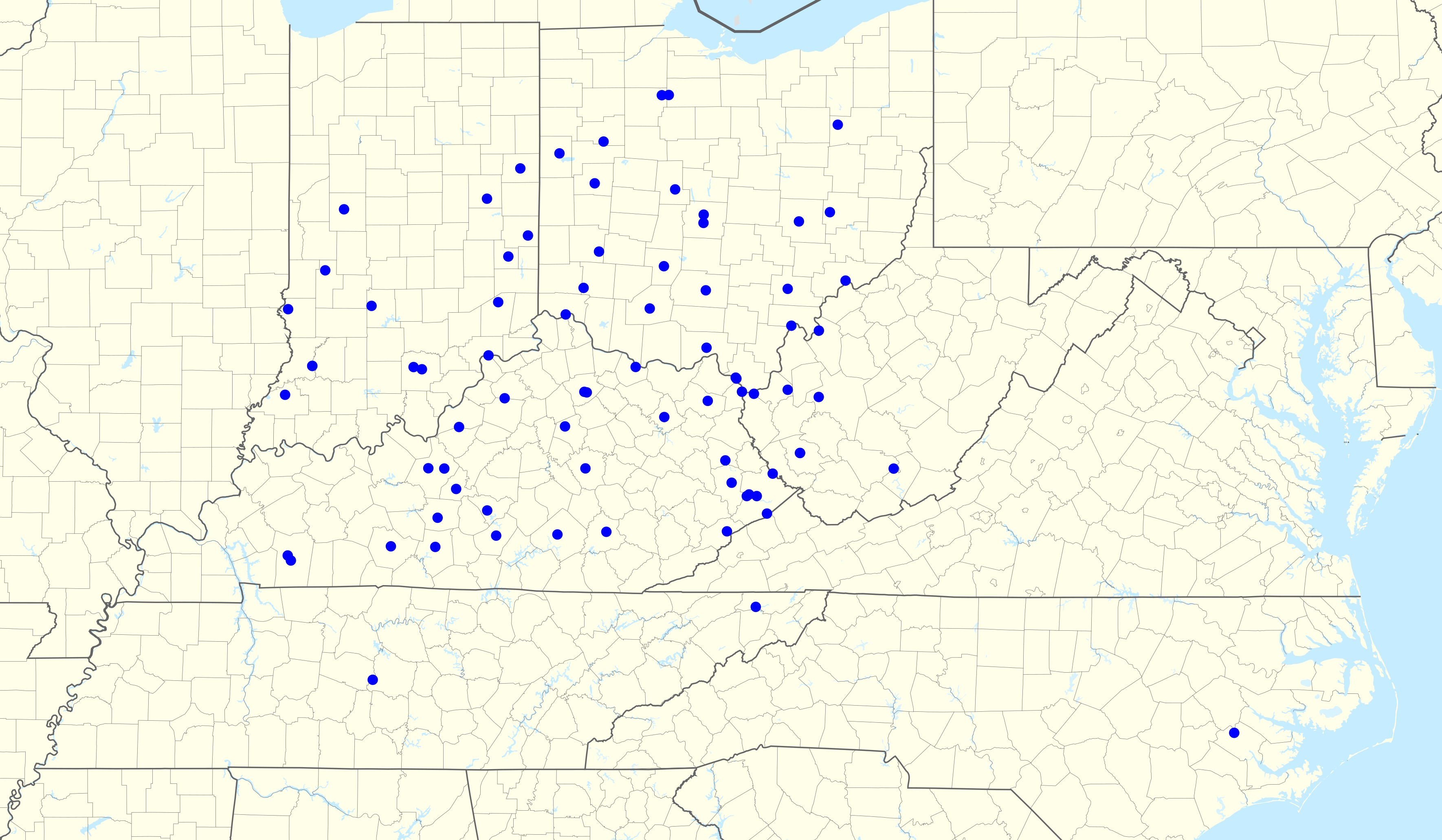
English: Cincinnati Reds Radio Network: map of radio affiliates. |
| Date | |
| Source |
AM-WATH => 39.344444444444, -82.105833333333
AM-WILE => 40.039444444444, -81.646666666667
AM-WTIG => 40.8325, -81.560833333333
AM-WBEX => 39.331111111111, -82.996944444444
AM-WLW => 39.353055555556, -84.326944444444
AM-WYTS => 39.941944444444, -83.022222222222
AM-WING => 39.682222222222, -84.159166666667
AM-WFOB => 41.101666666667, -83.399722222222
AM-WSRW => 39.166111111111, -83.606944444444
AM-WIRO => 38.539444444444, -82.671388888889
AM-WIMA => 40.679722222222, -84.109444444444
AM-WMOA => 39.419166666667, -81.476388888889
AM-WQTT => 40.246111111111, -83.330555555556
AM-WMPO => 39.010277777778, -82.066111111111
AM-WNXT => 38.810555555556, -82.989166666667
AM-WCHO => 39.549722222222, -83.452777777778
AM-WHIZ => 39.955555555556, -81.983611111111
AM-WGCL => 39.19, -86.634444444444
AM-WFNF => 39.512222222222, -87.138333333333
AM-WLPK => 39.6375, -85.145833333333
AM-WCVL => 40.065555555556, -86.933611111111
AM-WXGO => 38.741111111111, -85.361388888889
AM-WXFN => 40.161666666667, -85.378055555556
AM-WPGW => 40.436111111111, -85.015555555556
AM-WKBV => 39.828055555556, -84.9325
AM-WSLM => 38.615277777778, -86.086111111111
AM-WAMW => 38.645833333333, -87.279444444444
AM-WVHU => 38.393055555556, -82.473333333333
AM-WWKU => 37.010277777778, -86.423888888889
AM-WTCO => 37.335277777778, -85.375833333333
AM-WAIN => 37.107222222222, -85.278333333333
AM-WCYN => 38.405555555556, -84.292222222222
AM-WIEL => 37.715277777778, -85.842777777778
AM-WEKB => 37.306944444444, -82.331388888889
AM-WCDS => 37.004722222222, -85.940833333333
AM-WGOH => 38.328888888889, -82.975833333333
AM-WXAM => 37.530277777778, -85.713611111111
AM-WHOP => 36.881666666667, -87.512222222222
AM-WLXG => 38.097222222222, -84.529166666667
AM-WFTG => 37.141666666667, -84.079166666667
AM-WHBE => 38.091944444444, -85.682222222222
AM-WFTM => 38.636111111111, -83.760555555556
AM-WLOC => 37.269166666667, -85.915555555556
AM-WKYH => 37.789166666667, -82.784444444444
AM-WLSI => 37.465833333333, -82.551111111111
AM-WPKE => 37.480555555556, -82.526388888889
AM-WEKY => 37.716666666667, -84.306944444444
AM-WSFC => 37.1175, -84.611666666667
AM-WTCW => 37.146111111111, -82.766944444444
AM-WPWT => 36.461111111111, -82.453333333333
AM-WCHS => 38.364166666667, -81.768055555556
AM-WTCR => 38.411666666667, -82.603611111111
AM-WVOW => 37.856111111111, -81.971944444444
AM-WZZW => 38.429444444444, -82.105833333333
AM-WMOV => 38.965555555556, -81.766388888889
AM-WBTH => 37.669166666667, -82.269166666667
AM-WNOS => 35.319166666667, -77.247083333333
FM-WKKI => 40.5725, -84.589444444444
FM-WKFS => 39.112321428571, -84.521587301587
FM-WZCB => 40.017166666667, -83.019805555556
FM-WBVI => 41.1, -83.475555555556
FM-WLRX => 38.530938069217, -82.663902550091
FM-WMVR => 40.301111111111, -84.205833333333
FM-WRBI => 39.223611111111, -85.256111111111
FM-WSJD => 38.383888888889, -87.575208333333
FM-WSLM => 38.635277777778, -86.176944444444
FM-WNDI => 39.16, -87.542222222222
FM-WAMW => 38.646027777778, -87.27925
FM-WCYN => 38.410833333333, -84.318611111111
FM-WVKB => 37.718055555556, -86.016388888889
FM-WHBE => 38.3525, -85.185833333333
FM-WMDJ => 37.586666666667, -82.715833333333
FM-WMOR => 38.182222222222, -83.448888888889
FM-WPKE => 37.465670498084, -82.4425
FM-WHOP => 36.927092082486, -87.546495290445
FM-WBUZ => 35.800277777778, -86.621388888889
FM-WMTD => 37.714722222222, -80.9525
FM-WVOW => 37.856666666667, -81.971666666667
|
| Author |
|
| Point Maps
══▻ FAQ ◅══ ══▻ Create your own ◅══ |
Licensing
[edit]
I, the copyright holder of this work, hereby publish it under the following licenses:

|
Permission is granted to copy, distribute and/or modify this document under the terms of the GNU Free Documentation License, Version 1.2 or any later version published by the Free Software Foundation; with no Invariant Sections, no Front-Cover Texts, and no Back-Cover Texts. A copy of the license is included in the section entitled GNU Free Documentation License. |
This file is licensed under the Creative Commons Attribution 3.0 Unported license.
- You are free:
- to share – to copy, distribute and transmit the work
- to remix – to adapt the work
- Under the following conditions:
- attribution – You must give appropriate credit, provide a link to the license, and indicate if changes were made. You may do so in any reasonable manner, but not in any way that suggests the licensor endorses you or your use.
You may select the license of your choice.
File history
Click on a date/time to view the file as it appeared at that time.
| Date/Time | Thumbnail | Dimensions | User | Comment | |
|---|---|---|---|---|---|
| current | 01:13, 7 May 2017 | | 3,540 × 2,063 (1.13 MB) | Magog the Ogre (talk | contribs) | == {{int:filedesc}} == {{Information |Description={{en|Cincinnati Reds Radio Network: map of radio affiliates.}} |Source=;Data *http://cincinnati.reds.mlb.com/cin/schedule/redsradio_affiliates.jsp <pre> AM-WATH => 39.344444444444, -82.105833333333 AM-W... |
You cannot overwrite this file.
File usage on Commons
There are no pages that use this file.