File:Church at Welsh Bicknor.jpg
Jump to navigation
Jump to search
No higher resolution available.
Church_at_Welsh_Bicknor.jpg (640 × 452 pixels, file size: 431 KB, MIME type: image/jpeg)
Captions
Captions
Add a one-line explanation of what this file represents
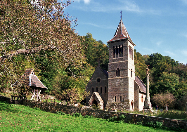
This is a photo of listed building number 1301949. |
Summary
[edit]
| Description |
English: St Margaret's parish church, Welsh Bicknor, Herefordshire, seen from the west. To the right of the tower is the 19th-century churchyard cross. |
| Date | |
| Source | From geograph.org.uk |
| Author | Richard Baker |
| Permission (Reusing this file) |
Creative Commons Attribution Share-alike license 2.0 |
| Camera location | | View this and other nearby images on: OpenStreetMap |
|---|
Licensing
[edit]

|
This image was taken from the Geograph project collection. See this photograph's page on the Geograph website for the photographer's contact details. The copyright on this image is owned by Richard Baker and is licensed for reuse under the Creative Commons Attribution-ShareAlike 2.0 license.
|
This file is licensed under the Creative Commons Attribution-Share Alike 2.0 Generic license.
Attribution: Richard Baker
- You are free:
- to share – to copy, distribute and transmit the work
- to remix – to adapt the work
- Under the following conditions:
- attribution – You must give appropriate credit, provide a link to the license, and indicate if changes were made. You may do so in any reasonable manner, but not in any way that suggests the licensor endorses you or your use.
- share alike – If you remix, transform, or build upon the material, you must distribute your contributions under the same or compatible license as the original.
File history
Click on a date/time to view the file as it appeared at that time.
| Date/Time | Thumbnail | Dimensions | User | Comment | |
|---|---|---|---|---|---|
| current | 23:27, 19 July 2008 | | 640 × 452 (431 KB) | Iain99 (talk | contribs) | {{Information |Description=The isolated church at Welsh Bicknor in the Wye Valley |Source=From [http://www.geograph.org.uk/photo/22709 geograph.org.uk] |Date=2004-10 |Author=[http://www.geograph.org.uk/profile/844 Rich |
You cannot overwrite this file.
File usage on Commons
The following 2 pages use this file:
File usage on other wikis
The following other wikis use this file:
- Usage on ceb.wikipedia.org
- Usage on cy.wikipedia.org
- Usage on dag.wikipedia.org
- Usage on en.wikipedia.org
- Usage on fa.wikipedia.org
- Usage on fr.wikipedia.org
- Usage on nl.wikipedia.org
- Usage on no.wikipedia.org
- Usage on pl.wikipedia.org
- Usage on www.wikidata.org
Categories:
- 1850s church towers in England
- Broach spires in Herefordshire
- Church spires in Herefordshire
- Church towers in Herefordshire
- Churchyard crosses in Herefordshire
- Churchyards in Herefordshire
- Forests in Herefordshire
- Gablet roofs in England
- Grade II listed buildings in Herefordshire
- Lychgates in Herefordshire
- St Margaret's church, Welsh Bicknor
- Stone crosses in Herefordshire
- Stone walls in Herefordshire