File:Christian Kruik van Adrichem. Ierusalem, et suburbia eius. 1584.jpg
Jump to navigation
Jump to search

Size of this preview: 414 × 600 pixels. Other resolutions: 166 × 240 pixels | 331 × 480 pixels | 530 × 768 pixels | 707 × 1,024 pixels | 1,414 × 2,048 pixels | 7,272 × 10,534 pixels.
Original file (7,272 × 10,534 pixels, file size: 21.74 MB, MIME type: image/jpeg)
Captions
Captions
Add a one-line explanation of what this file represents
Summary
[edit]
| Latina: Ierusalem, et suburbia eius | |
|---|---|
| Artist |
Christian Kruik van Adrichem (1533—1585)) |
| Author |
|
| Publisher | Braun, Georg and F. Hogenberg |
| Title |
Latina: Ierusalem, et suburbia eius |
| Description |
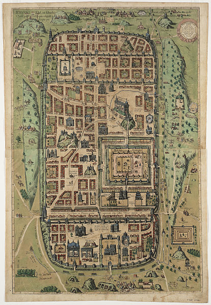
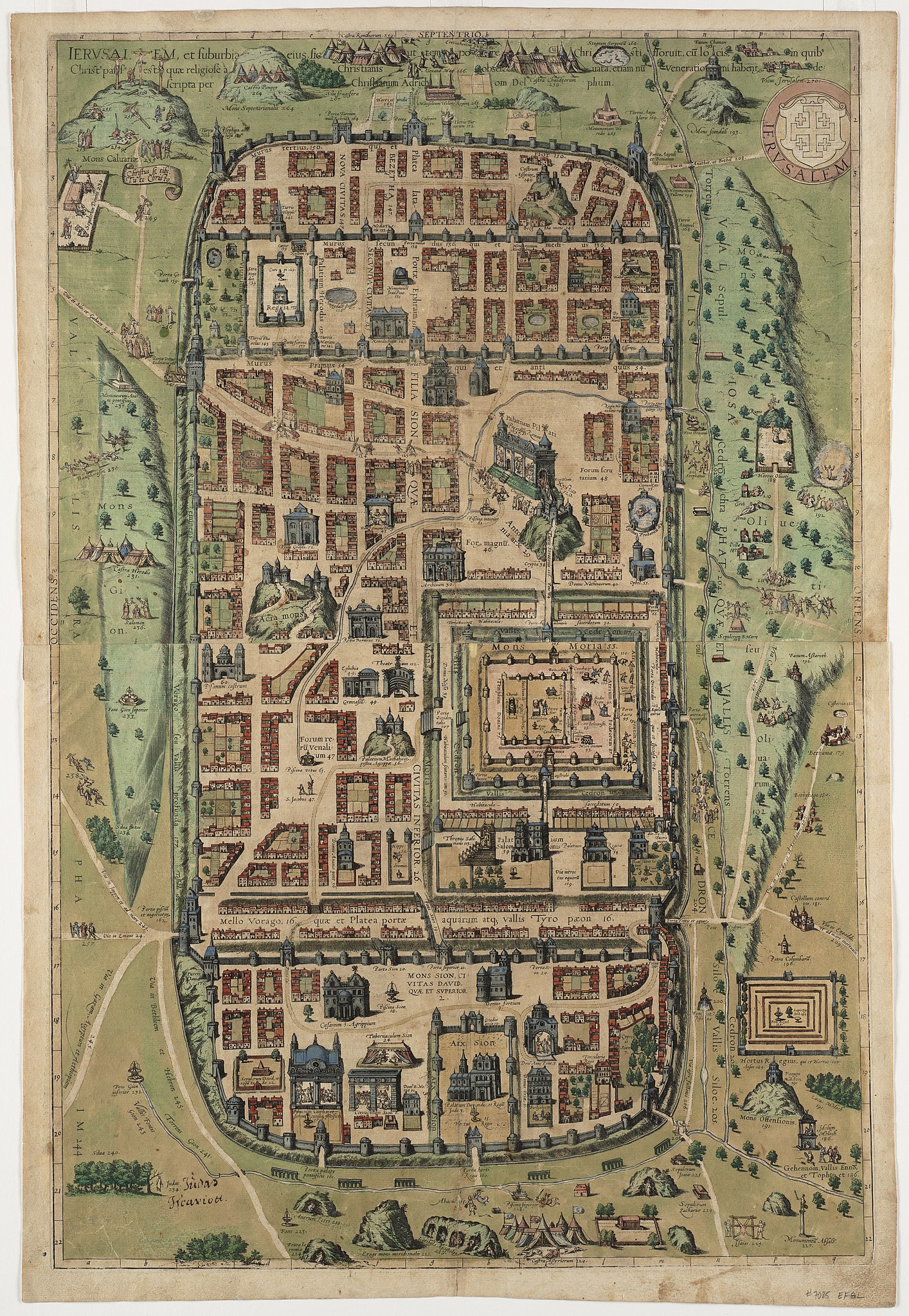
English: The final image of Jerusalem in Civitates Orbis Terrarum is the most dramatic. It appeared in the fourth volume on two pages, which are displayed here as a single sheet. Rather than a birds eye view, this depiction is more of a pictorial map, showing the facades of buildings placed adjacent to the streets and not drawn in perspective. As the extended title indicates, the map was compiled by Adrichem, a Dutch theologian and cartographer, to depict Jerusalem at the time of Christ. Adrichems map was originally published in 1584, but Braun and Hogenberg republished it with little change, except for the orientation. The original map, with a horizontal format, was oriented with west at top. In the Civitates, the map was rotated to a vertical format, placing north at the top. The map presents an imaginary conception of the city, with many buildings depicted as 16th century European structures. In addition there are 270 numbered and captioned scenes, showing sites or events mentioned in the Bible and other historical sources. Some date back to Kings David and Solomon, but many record events surrounding the life and crucifixion of Jesus. Published 1584 or 1588.
עברית: מפת ירושלים, כריסטיאן קראוק ואן אדריכם, 1584 |
| Date | 1584 |
| Dimensions | height: 72 cm (28.3 in); width: 48 cm (18.8 in) |
| Source/Photographer | maps.bpl.org |
| Other versions |
 |
Licensing
[edit]
|
This is a faithful photographic reproduction of a two-dimensional, public domain work of art. The work of art itself is in the public domain for the following reason:
The official position taken by the Wikimedia Foundation is that "faithful reproductions of two-dimensional public domain works of art are public domain".
This photographic reproduction is therefore also considered to be in the public domain in the United States. In other jurisdictions, re-use of this content may be restricted; see Reuse of PD-Art photographs for details. | ||||
File history
Click on a date/time to view the file as it appeared at that time.
| Date/Time | Thumbnail | Dimensions | User | Comment | |
|---|---|---|---|---|---|
| current | 21:11, 4 September 2015 | | 7,272 × 10,534 (21.74 MB) | Geagea (talk | contribs) | Transferred from http://maps.bpl.org/download?image=06_01_000903&full=1 |
You cannot overwrite this file.
File usage on Commons
The following 4 pages use this file:
File usage on other wikis
The following other wikis use this file:
- Usage on de.wikipedia.org
- Usage on ru.wikipedia.org