File:Chojnice (gmina wiejska) location map.png
Jump to navigation
Jump to search

Size of this preview: 375 × 600 pixels. Other resolutions: 150 × 240 pixels | 561 × 897 pixels.
Original file (561 × 897 pixels, file size: 125 KB, MIME type: image/png)
Captions
Captions
Add a one-line explanation of what this file represents
| Description |
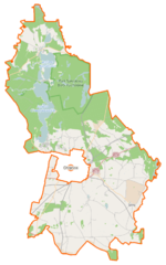
Polski: Mapa gminy Chojnice, Polska
English: Map of Gmina Chojnice, Poland |
|||||||||
| Date | ||||||||||
| Source | You may find a page on the OpenStreetMap wiki page for Chojnice (gmina wiejska) | |||||||||
| Creator |
OpenStreetMap contributors OpenStreetMap contributors |
|||||||||
| Permission (Reusing this file) |
OpenStreetMap data is available under the Open Database License (details). Map tiles are licensed under the Creative Commons Attribution-ShareAlike 2.0 license (CC-BY-SA 2.0).
This file is licensed under the Creative Commons Attribution-Share Alike 2.0 Generic license.
|
|||||||||
| Geotemporal data | ||||||||||
| Bounding box |
|
|||||||||
| Georeferencing | If inappropriate please set warp_status = skip to hide. | |||||||||
File history
Click on a date/time to view the file as it appeared at that time.
| Date/Time | Thumbnail | Dimensions | User | Comment | |
|---|---|---|---|---|---|
| current | 19:20, 14 January 2015 | | 561 × 897 (125 KB) | VanWiel (talk | contribs) | {{OpenStreetMap | name = Chojnice (gmina wiejska) | location = Chojnice (gmina wiejska) | description = {{pl|Mapa gminy Chojnice, Polska}} {{en|Map of Gmina Chojnice, Poland}} | top = 53.9286 | bottom... |
You cannot overwrite this file.
File usage on Commons
The following page uses this file:
File usage on other wikis
The following other wikis use this file:
- Usage on be.wikipedia.org
- Usage on de.wikipedia.org
- Usage on fr.wikipedia.org
- Angowice
- Babilon (Poméranie)
- Bachorze
- Białe Błota (Poméranie)
- Borne (Chojnice)
- Charzykowy
- Chociński Młyn
- Chojnaty
- Chojniczki
- Chojniczki-Wybudowanie
- Ciechocin (Poméranie)
- Cołdanki
- Czartołomie
- Doręgowice
- Drzewicz
- Funka
- Gockowice
- Granowo (Poméranie)
- Grzampki
- Jabłonka (Poméranie)
- Jakubowo (Chojnice)
- Jarcewo
- Jasnowo
- Kulki (Poméranie)
- Krojanty
- Kruszka (Poméranie)
- Kłodawa (Chojnice)
- Kopernica (Pologne)
- Kamionka (Chojnice)
- Kamionka nad jeziorem Zamarte
- Karolewo (Chojnice)
- Klawkowo
- Jeziorki (Poméranie)
- Józefowo (Poméranie)
- Melanówek
- Melanowo (Poméranie)
- Małe Swornegacie
- Małe Zanie
- Lotyń (Poméranie)
- Łukomie (Poméranie)
- Lichnowy (Chojnice)
- Lipienice (Poméranie)
- Kokoszka (Poméranie)
- Klucza
- Klosnowo
- Kłodawka (Poméranie)
- Płęsno
- Pomoc (Poméranie)
View more global usage of this file.
_location_map.png)
_location_map.png&oldid=857576773)