File:Chlorite-sericite schist (Neoarchean; Soudan Mine, Soudan, Minnesota, USA) 1 (21851519754).jpg

Original file (3,766 × 1,828 pixels, file size: 4.58 MB, MIME type: image/jpeg)
Captions
Captions
Summary
[edit]_1_(21851519754).jpg&action=edit§ion=1)
| Description |
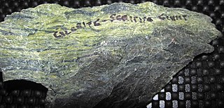
Chlorite-sericite schist from the Precambrian of Minnesota, USA. (public display, Soudan Underground Mine State Park visitor center, Soudan, Minnesota, USA) This is a chlorite-sericite schist from a shear zone in the deep subsurface of Minnesota's Soudan Mine. The mine targeted high-grade iron ores (specularites) from the Neoarchean-aged Soudan Iron-Formation (see: <a href="https://www.flickr.com/photos/jsjgeology/albums/72157652553006284">www.flickr.com/photos/jsjgeology/albums/72157652553006284</a>). The site is now a state park and underground tours are offered to the mine's 27th Level. Mapping of the Soudan Mine's 27th Level (see Vallowe et al., 2010) shows that iron-formation is "interbedded" with various schists that occur along old shear zones (fault zones). These shear zone schists are Neoarchean in age and may be related to (just predating or coeval with) the development of the ~2.68 billion year old Murray Shear Zone. Vallowe et al. (2010) provides this description of the sheared zone rocks and chlorite-sericite schist in particular: ". . . curvilinear bands of schistose rocks found along discrete ductile to brittle-ductile structures. Sheared rock units typically have anastomosing fabric composed of discrete foliation and shear banding (C-S structures)." and "Chlorite-Sericite Schist - Yellowish-green, fine-grained, highly foliated chlorite sericite schist. A very distinctive map unit underground recognized by its color and high degree of deformation." Locality: 27th Level of the Soudan Mine, Soudan Underground Mine State Park, Soudan, northeastern Minnesota, USA Site-specific geologic info. synthesized from: Vallowe et al. (2010) - Surface and subsurface geologic maps of the Soudan Underground Mine State Park, St. Louis County, northeastern Minnesota. Precambrian Research Center Map Series Map-2010-01. |
| Date | |
| Source | Chlorite-sericite schist (Neoarchean; Soudan Mine, Soudan, Minnesota, USA) 1 |
| Author | James St. John |
Licensing
[edit]_1_(21851519754).jpg&action=edit§ion=2)
- You are free:
- to share – to copy, distribute and transmit the work
- to remix – to adapt the work
- Under the following conditions:
- attribution – You must give appropriate credit, provide a link to the license, and indicate if changes were made. You may do so in any reasonable manner, but not in any way that suggests the licensor endorses you or your use.
| This image was originally posted to Flickr by James St. John at https://flickr.com/photos/47445767@N05/21851519754 (archive). It was reviewed on 5 December 2019 by FlickreviewR 2 and was confirmed to be licensed under the terms of the cc-by-2.0. |
File history
Click on a date/time to view the file as it appeared at that time.
| Date/Time | Thumbnail | Dimensions | User | Comment | |
|---|---|---|---|---|---|
| current | 05:51, 5 December 2019 | | 3,766 × 1,828 (4.58 MB) | Ser Amantio di Nicolao (talk | contribs) | Transferred from Flickr via #flickr2commons |
You cannot overwrite this file.
File usage on Commons
There are no pages that use this file.
_1_(21851519754).jpg&oldid=856890013)