File:Chinon (Indre-et-Loire) (22507323031).jpg

Original file (4,928 × 3,264 pixels, file size: 8.21 MB, MIME type: image/jpeg)
Captions
Captions
Summary
[edit]_(22507323031).jpg&action=edit§ion=1)
| Description |
Chinon (Indre-et-Loire)
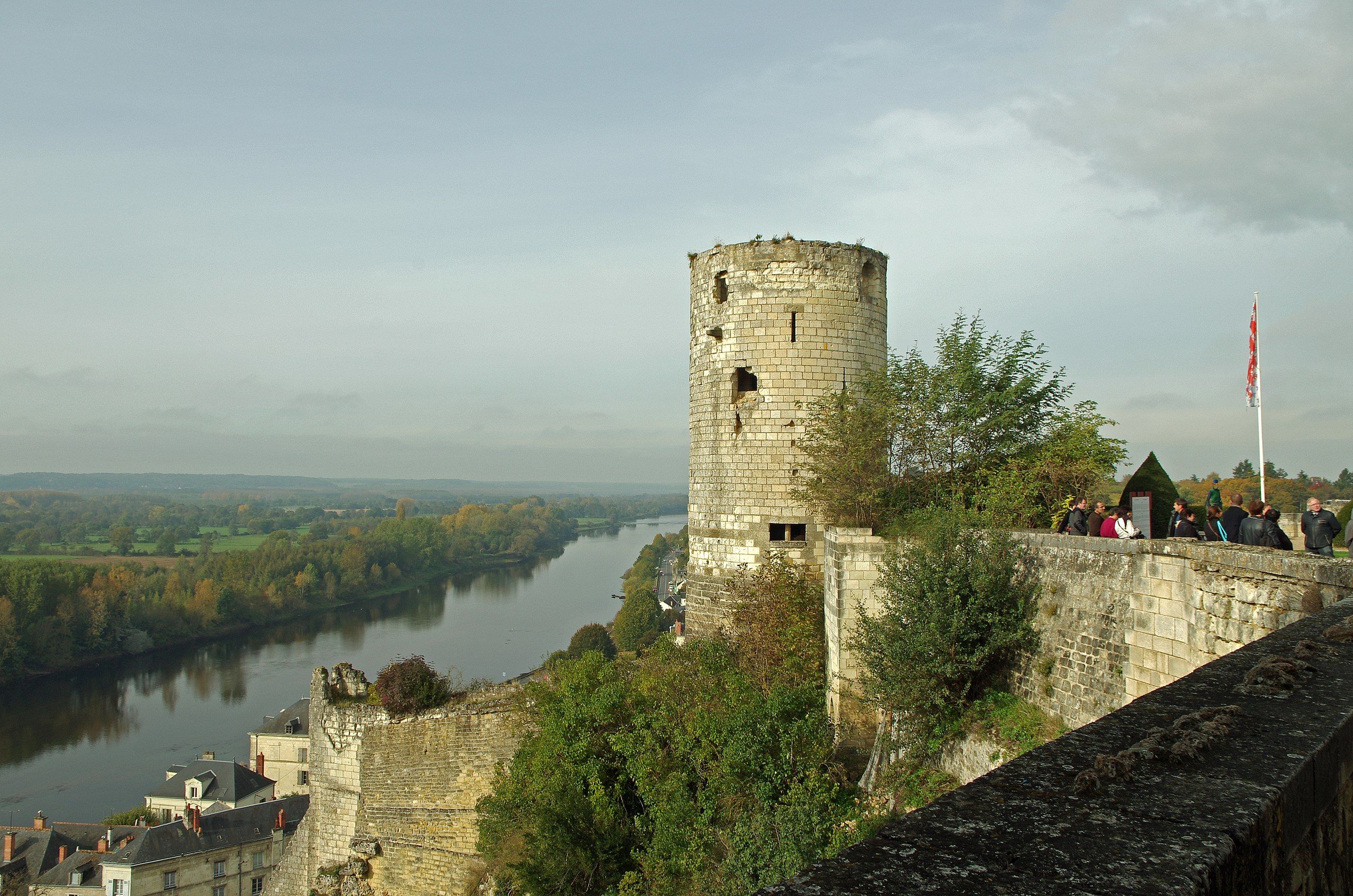
La tour du Moulin. La forteresse royale est divisée en trois châteaux: Le château du Milieu, le fort du Coudray et le fort Saint Georges (actuellement détruit). La tour du Moulin fait partie du fort du Coudray construit au XIIe siècle. La tour du moulin doit son nom à un moulin à vent perché à son sommet à une époque récente. Elle date à priori de Richard Cœur de Lion*. La tour du Moulin était protégée par une chemise, mur périphérique qui l'entourait pour la protéger. Il semble bien que la tour du Moulin enjambe une muraille antique. Le premier étage est accessible seulement par le chemin de ronde, il n'y a pas de communication avec le rez-de-chaussée. L'étage supérieure est accessible à partir du premier étage par un escalier qui permet également l'accès à la terrasse.
The tower of the Moulin. The royal fortress is divided into three castles: Castle Middle, Fort du Coudray and Fort St. George (now destroyed). The tower is part of the Fort du Coudray built in the twelfth century. The tower of the Mill is named after a windmill perched at the top in recent times. It dates a priori of Richard the Lionheart *. The tower of the mill was protected by a jacket, peripheral wall which surrounded it to protect it. It seems that the tower of the Moulin straddles an ancient wall. The first floor is accessible only by the covered way, there is no communication with the ground floor. The upper floor is accessible from the first floor by a staircase that allows access to the terrace.
|
| Date | Taken on 21 October 2015, 10:51 |
| Source | Chinon (Indre-et-Loire) |
| Author | Daniel Jolivet |
| Camera location | | View this and other nearby images on: OpenStreetMap |
|---|
_(22507323031).jpg¶ms=047.167930_N_0000.234886_E_globe:Earth_type:camera_source:Flickr_&language=en)
Licensing
[edit]_(22507323031).jpg&action=edit§ion=2)
- You are free:
- to share – to copy, distribute and transmit the work
- to remix – to adapt the work
- Under the following conditions:
- attribution – You must give appropriate credit, provide a link to the license, and indicate if changes were made. You may do so in any reasonable manner, but not in any way that suggests the licensor endorses you or your use.
| This image was originally posted to Flickr by sybarite48 at https://flickr.com/photos/26082117@N07/22507323031 (archive). It was reviewed on 17 November 2017 by FlickreviewR 2 and was confirmed to be licensed under the terms of the cc-by-2.0. |
File history
Click on a date/time to view the file as it appeared at that time.
| Date/Time | Thumbnail | Dimensions | User | Comment | |
|---|---|---|---|---|---|
| current | 16:27, 17 November 2017 | | 4,928 × 3,264 (8.21 MB) | Thesupermat2 (talk | contribs) | Transferred from Flickr via Flickr2Commons |
You cannot overwrite this file.
File usage on Commons
There are no pages that use this file.
_(22507323031).jpg&oldid=856750108)